
Vypin
9°58′26″N76°14′38″E/ 9.974°N 76.244°E
Vypin | |
|---|---|
Island | |
 Sunset at LNG Terminal in Vypin | |
| Country | |
| State | Kerala |
| Government | |
| • Body | Vypin Block Panchayat |
| Languages | |
| • Official | Malayalam,English |
| Time zone | UTC+5:30(IST) |
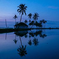
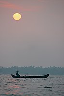
Vypin(IPA:[ʋɐi̯pːin],Cochin Portuguese:Isla Santa) is one of the group of islands that form part of the city ofKochi(Cochin), in the Indian state ofKerala.Vypin forms abarrier islandwhich lies between theArabian Seain the west and theCochin backwatersformed by the variousdistributariesofPeriyarriver, in the east. The northernmost end of the island lies on the estuary of the Periyar river in Muziris (Kodungallur), and the southernmost end in the mouth of the Cochin Backwaters in Kalamukku near Fort Vypin.

The island is about 27 kilometres (17 mi) long and is connected to mainland Kochi by a series of bridges known as theGoshree bridges,which start at Kalamukku in Vypin, touch other two islands and then finish atMarine Drivecovering a total distance of around three km (1.9 mi). Vypin is 58th most densely populated islands in the world.Njarakkalis one of the most densely populated locations within Vypin.
Development
[edit]At far the northern tip of Vypin, is home to the Munambam Fishing Harbour, the largest fishing harbour in Kochi. Puthuvype has become the major industrial hub in Kerala and the fastest growing city suburb due to the SPM project run byKochi Refineries,an offshore pumping station of Kochi Port, thePuthuvypLNGTerminal, the IOC Bottling Plant and the proposed Oceanarium.
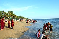
There are ten lighthouses inKerala,one of which is situatedat Puthuvype Beachand is the tallest in Kerala
India's first international container trans-shipment terminal (ICTT) in the Special Economic Zone at Vallarpadam Island, designed to handle the largest container ships, was opened by then Prime Minister Manmohan Singh on February 11, 2011.
There are regular boat services fromFort Kochito Vypin Island. In 2004 a bridge was built by theGoshree Islands Development Authority(GIDA) to connect Vypin to the mainland. TheGoshree bridgesalso connect the islandsMulavukadandVallarpadam.
Vypin is now a fast-developing suburb of Kochi City. Today, all the basic infrastructure of modern living is available in Vypin. Travellers from North Kerala can use the Vypin–Munambam state highway to reach Ernakulam.
History
[edit]The island was formed in 1341 following a heavy flood.
Villages of Vypin
[edit]- Cherai
- Edavanakkad
- Elamkunnapuzha
- Fort Vypin
- Kuzhuppilly
- Malippuram
- Munambam
- Murikumpadam
- Nayarambalam
- Nedungad
- Njarackal
- Ochanthuruth
- Pallippuram
- Perumpilly
- Puthuvype
-
 Nedungad
 -
 Cricket at Puthyvypin Beach
 -
 Vembanad Kayal
 -
 Cherai Beach
 -
 Pallipuram Fort
 -
 Sunrise at Veeranpuzha


See also
[edit]External links
[edit]Areas of Kochi | |
|---|---|