Wankaner State
| Wankaner State | |||||||
|---|---|---|---|---|---|---|---|
| Princely State | |||||||
| 1620–15 August 1947 | |||||||
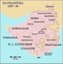
 Location of Wankaner State in Saurashtra | |||||||
| Capital | Wankaner | ||||||
| Area | |||||||
• 1931 | 1,075 km2(415 sq mi) | ||||||
| Population | |||||||
• 1931 | 44,259 | ||||||
| History | |||||||
• Established | 1620 | ||||||
• British seizuranity ended | 15 August 1947 | ||||||
| |||||||

Wankaner Statewas one of theprincely statesofIndiain the historicalHalarregion ofKathiawarduring the period of theBritish Raj.It was an eleven gunsalute statebelonging to theKathiawar Agencyof theBombay Presidency. Its capital was inWankaner,located inRajkot district,Gujaratstate. Most of the territory of the state wasmountainous.[citation needed]
History
[edit]Wankaner State was founded in 1620 by Raj Sartanji, son of Prathirajji, eldest son of Raj Chandrasinghji ofHalvad(1584–1628).[citation needed]
In 1807 Wankaner State became aBritish protectoratewhen Maharana Raj Sahib Chandrasinhji II Kesarisinhji signed a treaty with the British. In 1862 the ruler of the state received asanadgiving the monarch authorization to adopt an heir. The ruler acceded to theIndian Unionon 15 February 1948.[citation needed]


