
Wenum-Wiesel
Wenum-Wiesel | |
|---|---|
Twinvillage | |
 Estate "De Ploeg" | |
 Wenum-Wiesel Location in the province ofGelderland  Wenum-Wiesel Wenum-Wiesel (Netherlands) | |
| Coordinates:52°15′13″N5°57′15″E/ 52.2537°N 5.9542°E | |
| Country | Netherlands |
| Province | Gelderland |
| Municipality | Apeldoorn |
| Area | |
| • Total | 30.65 km2(11.83 sq mi) |
| Elevation | 16 m (52 ft) |
| Population (2021)[1] | |
| • Total | 2,170 |
| • Density | 71/km2(180/sq mi) |
| Time zone | UTC+1(CET) |
| • Summer (DST) | UTC+2(CEST) |
| Postal code | 7345[1] |
| Dialing code | 055 |
Wenum-Wieselis a twin village in the municipality ofApeldoorn,in the province ofGelderlandin theNetherlands.In 1978, the hamlets of Wenum and Wiesel merged into a village.
History
[edit]Wenum was first attested in 1335 as "in der Merck to Wenen",[3]however thewatermillwas already mentioned in 1313.[4]The etymology of the name is unclear.[3]Wiesel was first attested in 1337 as Wiessel, and means pasture near a forest.[5]
In 1684,William III of Orangebought approximately 100 square kilometres (39 sq mi) of forest and heath in the area as acrown land.The land included the village of Wiesel. He intended to build his palace inHoog Soeren,but changed his mind and boughtHet Loo Palacein Apeldoorn.[6][7]In 1840, Wenum was home to 256 people, and Wiesel to 243 people.[8]
In 1876, theAmsterdam–Zutphen railwaywas completed, andWilliam III of the Netherlandswanted a side track to his palace. In 1887, theApeldoorn–Zwolle railwayline was completed and partially used the side track. A railway stop was constructed at Wenum. The station closed in 1938.[9][10]In 1840, thegristmillGrondzeiler Wenumwas built in Wenum. The current windmill dates from 1913.[11]
In 1978, the hamlets of Wenum and Wiesel merged into the twin village Wenum-Wiesel. The hamlets are still somewhat separated. The place name signs are chaotic and sometimes use the combined name, or the individual hamlet. The village has a combined school, and village council.[8]
Gallery
[edit]-
![Windmill Grondzeiler Wenum [nl]](https://upload.wikimedia.org/wikipedia/commons/thumb/d/dc/Wenum_Wenumermolen_05.JPG/90px-Wenum_Wenumermolen_05.JPG) WindmillGrondzeiler Wenum
WindmillGrondzeiler Wenum -
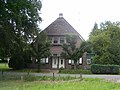
 Klein Cannenburgh
 -
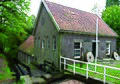 Watermill of Wenum
 -
 Farm in Wenum
![Windmill Grondzeiler Wenum [nl]](/translate/en.wikipedia.org?u=https%3A%2F%2Fen.wikipedia.org%2Fwiki%2FFile%3AWenum_Wenumermolen_05.JPG&t=hv)


References
[edit]- ^abc"Kerncijfers wijken en buurten 2021".Central Bureau of Statistics.Retrieved19 March2022.
The hamletBeemte-Broekland(1,035 inhabitants - 12.79 km2) has been subtracted from the total
- ^"Postcodetool for 7345AA".Actueel Hoogtebestand Nederland(in Dutch). Het Waterschapshuis.Retrieved19 March2022.
- ^ab"Wenum - (geografische naam)".Etymologiebank(in Dutch).Retrieved19 March2022.
- ^Ronald Stenvert & Sabine Broekhoven (2000)."Apeldoorn"(in Dutch). Zwolle: Waanders. p. 78.ISBN90 400 9406 3.Retrieved19 March2022.
- ^"Wiesel - (geografische naam)".Etymologiebank(in Dutch).Retrieved19 March2022.
- ^"Hoog Soeren - (geografische naam)".Etymologiebank(in Dutch).Retrieved19 March2022.
- ^"Wieselsche bosch (Kroondomein)"(PDF).IVN Apeldoorn(in Dutch).Retrieved19 March2022.
- ^ab"Wenum-Wiesel".Plaatsengids(in Dutch).Retrieved19 March2022.
- ^"Trein".Gelderland Binnenste Buiten(in Dutch). Archived fromthe originalon 7 April 2014.Retrieved19 March2022.
- ^"Station Wenum".Stationsweb(in Dutch).Retrieved19 March2022.
- ^"Wenum, Gelderland".Molendatabase(in Dutch).Retrieved19 March2022.