Wikipedia talk:WikiProject U.S. states/mockups
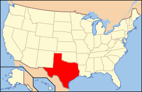
The following is a mockup created to test out the images of the USA highlighting the state, and the state's close-up image with scalebar and capital. Created byWapcaplet.Comments welcome.
| |||
Statenickname:Lone Star State | |||
|
Other U.S. states | |||
| Capital | Austin | ||
| Area - Total - Land - Water - % water |
Ranked 2nd | ||
| Population
-Density |
Ranked 2nd
30/km² | ||
| Admittance into Union
- Date | 28th | ||
| Time zone |
Central:UTC-6/-5 | ||
|
Latitude |
25°50'N to 36°30'N | ||
|
Width |
1,065 km | ||
| ISO 3166-2: | US-TX | ||
Texas(oldSpanishTejas) is astateof theUnited States of America.
The state name derives from aCaddoword meaningfriendsorallies,and was mistakenly applied to the people and their location by Spanish explorers.
The state flower is thebluebonnet(Lupinus texensis); the state motto is "Friendship." The state nickname isThe Lone Star State,after the single star on the state flag. The state tree is thepecanand the state bird is themockingbird.
Texas (area690,000km2) is the second largest state in size afterAlaskaand has historically been portrayed as larger than life, especially incowboy filmsandoilwells.
Location[edit]
Texas is bordered to the west byNew Mexico,to the north byOklahoma(across theRed River), and to the east byLouisiana(across theSabine River) andArkansas.To the south west Texas bordersMexico(across theRio Grande), the states ofChihuahua,Coahuila,Nuevo Leon,andTamaulipas.To the south east Texas has a shore of theGulf of Mexico.
Texas is located in the south center of the United States. Depending on who you talk to (and which part of Texas they are from), Texas is part of theUS Southor theUS Southwest.Texas shares some cultural elements with both regions, with more similarites to the South in the east of the state, and more similarities to the Southwest in the west.
History[edit]
Texas was part of theSpanishcolony ofNew Spain;seeSpanish Texasfor details.
AfterMexicanindependence in1821Texas was a part of Mexico. SeeMexican Texas.
Also seeTexas Revolution.
TheRepublic of Texas(1836-1845)[edit]
Texas was the first sovereign nation (other than aboriginal nations) to be annexed by the United States. (The other was the Kingdom ofHawaii.) The area now known as Texas was calledThe Republic of Texasfrom1836to1845.
Important dates:[edit]
- 1519.Alonso Alvarez de Pineda,aSpanishexplorer, was probably the firstEuropeanto map the Texas coast.
- 1528-1534.Álvar Nuñez Cabeça de Vaca,another Spanish explorer, spent six years visiting Texas for trade.
- 18 February1685.Rene-Robert Cavelier,Sieur de LaSalleestablished Fort St. Louis atMatagorda Bay,thus laying claim to Texas byFrance.
- 1700-1799.Spain established Catholic missions in Texas throughout the18th century.
- 3 January1823.Stephen F. Austinbegan a colony of 300 families in theBrazos Riverregion. This group is now known as the "Old Three Hundred".
- 26 June1832.TheBattle of Velascoresulted in the first casualties of the developing Texas Revolution.
- 1832-1833.The "Conventions" of 1832 and 1833 were triggered by rising unrest at the policies of the rulingMexicangovernment. Among the policies that most irritated the Texians were the Mexican ban on slavery, the forcible disarmament of Texian settlers, and the expulsion of illegal immigrants from theUnited States of America.The example of the Centralista forces' suppression of dissidents in Zacatecas also inspired fear of the Mexican government.
- Texas RevolutionEarly in1835,Stephen F. Austinannounced that war with Mexico was necessary to secure Texian freedom.
- 2 October1835.Texians fought a Mexican Cavalry detachment at the town ofGonzales,which began the actual revolution.
- 28 October1835.At the "Battle of Concepcion",90 Texians defeated 450 Mexicans.
- 2 March1836.The "Convention of 1836" signed the Texas "Declaration of Independence", making an attempt at a clear break from Mexican rule.
- 6 March1836.Approximately 190 Texians, led byWilliam B. Travis,were besieged at theAlamoin San Antonio by the Mexican army (numbering 4,000 to 5,000). The thirteen-day siege resulted in the deaths of all of its defenders, includingDavy Crockett,Jim Bowieand Travis.
- 27 March1836.By the order of Santa Anna, the Mexicans executed James Fannin and nearly 400 Texians in the Massacre at Goliad.
- 21 April1836.General Santa Anna, having defeated the Texas rebellion, while conducting mopping up operations advanced toSan Jacintoin pursuit of the fleeing rebels. Led bySam Houston,independence was won in one of the most decisive battles in history when Texians defeated Mexican forces of Santa Anna at the "Battle of San Jacinto". The entire Mexican force of 1,600 men was killed or captured by Houston's army of 800, with only nine fatal casualties.Santa Annawas among the captives.
- 14 May1836.The treaty of Velasco was signed by Republic of Texas Officials and GeneralSanta Anna.
- 1836.Five cities served as temporary capitals of Texas (Washington-on-the-Brazos,Galveston,Harrisburg,Velasco,andColumbia) before Sam Houston moved the capital toHoustonin1837.
- 5 March1842.A Mexican force of over 500 men, led by Rafael Vasquez, invaded Texas for the first time since the revolution. They soon headed back to the Rio Grande after briefly occupying San Antonio.
- 11 September1842.San Antonio was captured again by 1400 Mexican troops, led by Adrian Woll. They retreated, as before, but with prisoners this time.
- 29 December1845.PresidentJames K. Polkfollowed through on a campaign platform promising to annex Texas, and signed legislation making Texas the 28th state of the United States.
- 1 February1861.Following a 171 to 6 vote by the "Secession Convention", Texas seceded from the Union.Sam Houstonwas one of the voters who opposed secession.
- 30 March1870.The United States Congress readmitted Texas into the Union.
- 20 January2001.George W. Bushis inagurated. Born inNew Haven, Connecticuthe was raised inMidland, Texas.
Law and Government[edit]
Its capital isAustin,also known as the "Live Music Capital of the World." The Capitol is loosely modeled after the Capitol Building in Washington, DC, except that it is built of pink granite and its dome is topped by a statue of the "Goddess of Liberty", holding aloft a five-point Texas star. The capitol building is taller than the national capitol, but less massive.
Geography[edit]
Texas has five major topographic regions: 1) The Coastal Plain, from the Gulf of Mexico inland to about San Antonio and just southeast of Austin. 2) The Balcones, a hilly rocky area in east central Texas. 3) The Great Plains region extends into northern Texas, inluding the Llano Estacado and the Panhandle high planes. 4) The North Central Plains. 5) The Trans Pecos Desert.
Texas is divided into 254counties;See:List of Texas counties
Economy[edit]
Texas was lagely rural beforeWorld War IIwithcattle ranching,oil, andagricultureas its main industries. In1926San Antoniowas the largest city in Texas with over 120,000 people.
AfterWorld War II,Texas has become increasingly industralized. Its economy (circa 2000) is largely based on information technology, withDallas-Fort WorthMetroplexbeing the largestITlabor market in theUnited States,oil andnatural gas,energy exploration and energy trading, agriculture, and manufacturing. Major cities includeHouston,Brownsville,McAllen,Tyler,OdessaandMidland.Other important cities includeEl Paso,Eagle Pass,andLaredo;these are very important because of their location at the borderline with Mexico, making them important trade points.
The state passedNew Yorkin the1990sto become the second largest state in population afterCalifornialargely due to the availability of jobs, low cost of living, high living standard, lack of a state income tax, low taxation of business, limited government (the state legislature of Texas meets only once every two years), warm weather, and friendly people.
Demographics[edit]
As of2000,the population of the state is 20,851,820.
Texas has a large number of Spanish speaking people some of whom have recently immigrated from Mexico,Central America,andSouth Americabut includes others, known asTejanos,whose ancestors have lived in Texas since before independence from Mexico. Unlike other United States states which border Mexico, the culture of Texas gradually merges into that of Mexico producing a vibrant border region.
Texas has been largely fortunate in avoiding the racial and ethnic problems found in many southern states and large cities of the northeast. Much of this is because Texas's immigrant population and cultural connections with Mexico are considered to have a highly positive influence on the area's economy.
But Texas' diversity comes from more than its Hispanic residents. Frontier Texas was also settled by Germans, Poles, Swedes, Norwegians, Czechs, and French, and their influence can still be noted in the names of towns, styles of architecture, genres of music, and variety of foods.
Important Cities and Towns[edit]
Well, I think it's better than the small map that is on the articles now, but the addition of these relatively large images makes the table somewhat cluttered. A simpler format for the table (oreliminating the table entirely) might reduce this problem; the state images could conceivably be made smaller, but 280 pixels in width was chosen as a good fit for the existing table size, and it'd be hard to make the maps much smaller without illegibility. There's certainly room for improvement. Comments? --Wapcaplet12:48 17 Jul 2003 (UTC)
- The table looks a little....um....long. Maybe you can have the maps moved out of the table and listed next to the geography section. --Jiang
True. I personally think the tables in these articles can be simplfied (and turned into more appropriate structures, such as lists; this is discussed onmeta). I suppose most of what I'm interested in having comments on is the images themselves. A few things to note:
- The red-on-white colors for the USA map were chosen to be consistent with the U.S. county articles (See discussion atWikipedia talk:WikiProject U.S. Counties/mockups). The primary goal of this map is to show the state's location within the U.S. (though Alaska and Hawaii don't really follow this rule, due to scale problems).
- A yellow background, instead of white, is used for the state close-up. The primary goal for this image is to illustrate the geography and political boundaries of the state (whereas with the counties, the overriding goal was to show the location of the county).
- The scale bar is auto-generated based on data tediously collected by me from the original state outline images. The subdivisions (red/white boxes) within the scale bars is kind of a hack, and I am not sure it is wholly appropriate (since it seems to be a carry-over from print media, where people can hold a ruler up to it and measure scale on the map; on the screen, it's mostly there to just give a sense of perspective.)
Other things I considered doing with the state close-up:
- Showing time zone information (which would be irrelevant for many states, which only occupy one time zone, but could be important for larger states such as Texas which occupy more than one time zone)
- Showing bodies of water, lakes, rivers, etc. This would necessitate a tremendous amount of extra work, since the original maps were the same outline maps used for counties, and do not show bodies of water.
- Similarly, showing adjoining states
- Showing location of other important cities
These things I deemed too complex; if someone would like to add them, that'd be great! But it seems like something that would be better handled when we get some properWikipediatlassoftware and markup.
--Wapcaplet14:05 17 Jul 2003 (UTC)


