List of World Heritage Sites in Canada
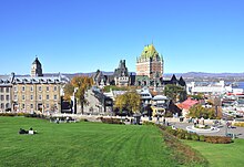
TheUnited Nations Educational, Scientific and Cultural Organization(UNESCO)World Heritage Sitesare places of importance toculturalornatural heritageas described in the UNESCOWorld Heritage Convention,established in 1972.[1]Cultural heritage consists of monuments (such as architectural works, monumental sculptures, or inscriptions), groups of buildings, and sites (including archaeological sites). Natural features (consisting of physical and biological formations), geological and physiographical formations (including habitats of threatened species of animals and plants), and natural sites which are important from the point of view of science, conservation, or natural beauty, are defined as natural heritage.[2]Canadaaccepted the convention on 23 July 1976.[3]There are 22 World Heritage Sites in Canada, with a further 10 on the tentative list.[3]
The first two sites in Canada added to the list wereL'Anse aux MeadowsandNahanni National Park Reserve,both at the Second Session of theWorld Heritage Committee,held inWashington, D.C.,in 1978.[4]The most recent sites listed wereTr’ondëk-KlondikeandAnticosti,both in 2023.[3]Two sites are shared with the United States. Ten sites are listed for their cultural significance, eleven for natural significance, and one,Pimachiowin Aki,is listed for both. Canada has served as a member of the World Heritage Committee four times: 1976–1978, 1985–1991, 1995–2001, and 2005–2009.[3]
World Heritage Sites[edit]
UNESCO lists sites underten criteria;each entry must meet at least one of the criteria. Criteria i through vi are cultural, and vii through x are natural.[5]
| Site | Image | Location | Year listed | UNESCO data | Description |
|---|---|---|---|---|---|
| L'Anse aux Meadows National Historic Site | 
|
Newfoundland and Labrador | 1978 | 4bis; iv (cultural) | L'Anse aux Meadows is an 11th-centuryVikingsettlement at the tip of theGreat Northern Peninsula,and is the earliest documented European settlement in the New World. The complex contains eightturf houses:three dwellings, one forge, and four workshops used for ship repair. The architecture and artifacts are in the same style as those fromNorse Greenlandand Iceland from the same period. A minor boundary modification of the site took place in 2017.[6] |
| Nahanni National Park | 
|
Northwest Territories | 1978 | 24; vii, viii (natural) | The park is listed for its outstanding geomorphological features. The rivers of the park, in particular theSouth Nahanni River,carved deep canyons through the mountain ranges and created several waterfalls (Virginia Fallspictured). There arekarstlandforms, includinglimestonecave systems. The park is undisturbed and is home to animals of boreal forests, includinggrizzly bear,wolf,andcaribou.[7] |
| Dinosaur Provincial Park | 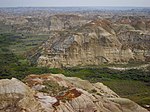
|
Alberta | 1979 | 71; vii, viii (natural) | The area is a practically undisturbed semi-arid steppe withbadlandstopography. Fossils of more than 44 species, 34 genera, and 10 families ofdinosaurshave been discovered in the park, representing every known group ofCretaceousdinosaurs. More than 150 complete skeletons have been unearthed, together with several non-dinosaur fossils. They provide insight into the life in the area 77 to 75 million years ago.[8] |
| SG̱ang Gwaay | 
|
British Columbia | 1981 | 157; iii (cultural) | This site preserves a 19th-century village of theHaida peopleon theHaida Gwaiiarchipelago off theBritish Columbia Coast.The site comprises the remains of large cedarlonghousesand several carved mortuary and memorialtotem poles(some examples pictured). They illustrate the art and traditions of the Haida people.[9] |
| Head-Smashed-In Buffalo Jump | 
|
Alberta | 1981 | 158bis; vi (cultural) | Buffalo jumpwas a traditional way of huntingbisonby thePlains Indiansover nearly six millennia. Knowing the topography and bison behavior, the hunters directed bison herds into drive lanes that ended at a cliff, resulting in bison falling to their deaths. This site is one of the prominent examples of this tradition. The bison carcasses were then butchered and processed at a camp below. A minor modification of the site boundaries took place in 2021.[10] |
| Wood Buffalo National Park | 
|
Alberta,Northwest Territories | 1983 | 256; vii, ix, x (natural) | The park covers large areas of grass andsedgemeadows, boreal forests, lakes, rivers, and the world's largest inland delta, thePeace–Athabasca Delta.There are also salt plains andgypsumkarst features. It is home to North America's largest population of wildbison,and is a breeding ground for the endangeredwhooping crane.[11] |
| Canadian Rocky Mountain Parks | 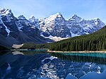
|
Alberta,British Columbia | 1984 | 304bis; vii, viii (natural) | Seven national parks in theCanadian Rockies,two of which were added to the site in 1990, exhibit mountain landscapes of exceptional natural beauty, with glaciers, ice fields, alpine meadows, cave systems, lakes, and waterfalls. TheBurgess Shaleformation, one of the world's most important fossil assemblies, is located here. It preserves the remains of soft-bodied animals dating to theCambrianperiod, providing key insight into the development of major animalphyla.[12] |
| Historic District of Old Québec | 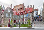
|
Quebec | 1985 | 300; iv, vi (cultural) | Founded by the French in the 17th century as the capital ofNew Franceand then developed by the British after the 1760s, the old part of Quebec illustrates different stages of European colonial settlement in North America. In addition to the well-preserved urban centre, thefortifications of the city,withbastions,ramparts,and other defensive structures, are unique north of Mexico.[13] |
| Gros Morne National Park | 
|
Newfoundland and Labrador | 1987 | 419; vii, viii (natural) | With deep ocean crust and rocks of theEarth's mantlelying exposed, the park illustrates plate tectonics andcontinental drift.Landlocked freshwater fjords and glacier-scoured headlands in an ocean setting contribute to the natural beauty of this wilderness area.[14] |
| Kluane / Wrangell–St. Elias / Glacier Bay / Tatshenshini-Alsek* | 
|
Yukon | 1992 | 72ter; vii, viii, ix, x (natural) | The four national parks and protected areas spanning the border between the United States and Canada contain the world's largest non-polarice fieldand numerous largeglaciers.The area, shaped by glacial and continuous tectonic activity, comprises different types of habitats, from high mountains above 16,000 ft (5,000 m) to ocean, coastal forests, and river valleys. Some of the important animal species includegrizzly bear,caribou,Dall sheep,andmountain goat.The rivers are spawning grounds forsalmonthat then migrate to the ocean.Glacier Bay(US) was originally listed alone in 1979.Kluane(Canada, pictured) andWrangell–St. Elias(US) were added to the site in 1992, andTatshenshini-Alsek(Canada) in 1994.[15][16][17] |
| Waterton-Glacier International Peace Park* | 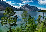
|
Alberta | 1995 | 354rev; vii, ix (natural) | This site comprises theWaterton Lakes National Park(pictured) in Canada and theGlacier National Parkin the US. Both parks are known for their outstanding scenic beauty due to mountains and glacial landforms. The park straddles theContinental Divideand includes theTriple Divide Peak.The mountains meet theprairiewithout intervening foothills and the geography allowed the animal and plant species typical ofPacific Northwestto spread inland. This resulted in a high number of animal and plant species present in a small area.[18] |
| Old Town Lunenburg | 
|
Nova Scotia | 1995 | 741; iv, v (cultural) | Founded by the British in 1753, Lunenburg is the best surviving example of a planned British colonial settlement in North America. The grid plan from the 18th century has been preserved, as well as some of the wooden buildings from that period. The community is based on the offshore Atlantic fishery.[19] |
| Miguasha National Park | 
|
Quebec | 1999 | 686rev; viii (natural) | The park encompasses parts of theEscuminac Formation,ageological formationdating to theDevonianperiod 370 million years ago. It is an exceptional paleontologist site, yielding large numbers of exceptionally well-preserved fossils of fish, in particular thelobe-finned fishthat later gave rise to thetetrapods.Invertebrate and plant fossils have been found at the site as well.[20] |
| Rideau Canal | 
|
Ontario | 2007 | 1221; i, iv (cultural) | The oldest continuously operatedcanalsystem in North America, with much of its original structure intact, connectsOttawa,on theOttawa River,toKingston,onLake Ontario.It opened in 1832 as a precaution in case of war with the United States, allowing the transit of steam-powered ships. The site includes severaldefensive works in Kingston.The Ottawa Locks atColonel By Valleyare pictured.[21] |
| Joggins Fossil Cliffs | 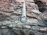
|
Nova Scotia | 2008 | 1285; viii (natural) | The site at Joggins has produced one of the best fossil records from theCarboniferousperiod, in particular from 318 to 303 million years ago. During that time, the area was covered by rainforests, the remains of which are the main sources of today's coal. In addition to plant fossils (alycopsidpictured), the remains of the earliestamniotesillustrate the evolution of terrestrial vertebrates.[22] |
| Landscape of Grand Pré | 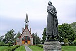
|
Nova Scotia | 2012 | 1404; v, vi (cultural) | Thecultural landscapewas shaped by theAcadians,descendants of the French settlers, in the 17th and 18th centuries. Using dyke-building techniques calledaboiteau,the farmers reclaimed salt marshes from the tidal areas and repurposed them for agricultural use. The water management system remains in use in the present day. The site is also inscribed as a memorial to the Acadian way of life and their deportation, which started in 1755, known as theGrand Dérangement.[23] |
| Red Bay Basque Whaling Station | 
|
Newfoundland and Labrador | 2013 | 1412; iii, iv (cultural) | TheBasque whaling stationwas founded in the 1530s and was used for about 70 years. It provided support for hunting and processing of whales to producewhale oilfor sale in Europe. With the archaeological remains illustrating different stages of the pre-industrial whaling process, Red Bay is the best preserved station from that period.[24] |
| Mistaken Point | 
|
Newfoundland and Labrador | 2016 | 1497; viii (natural) | The reserve is home to the namesakeMistaken Point Formation,which contains one of the most diverse and well-preserved collections ofPrecambrianfossilsin the world.Ediacaran fossils,dating from 580-560 million years ago, constitute the oldest known remnants ofmulticellular lifeon Earth.[25] |
| Pimachiowin Aki | 
|
Manitoba,Ontario | 2018 | 1415rev; iii, vi, ix (mixed) | Thecultural landscapeof Pimachiowin Aki is the ancestral home of fourAnishinaabeFirst Nationscommunities, thePoplar River,Little Grand Rapids,Pauingassi,andBloodvein.It comprises a network of habitation sites, ceremonial sites, trade routes, and waterways. From the natural perspective, the area represents the largest example of the North Americanboreal shield,with animals such asmoose,wolf,wolverine,andlake sturgeon.[26] |
| Writing-on-Stone / Áísínai’pi | 
|
Alberta | 2019 | 1597; iii (cultural) | Thecultural landscapeconsisting ofprairieandcouleehabitats is sacred to theBlackfootpeople. For millennia, people carved rock art with spiritual meaning on the sandstonehoodoosalong theMilk River,with the oldest carvings being around 3,000 years old.[27] |
| Tr’ondëk-Klondike | 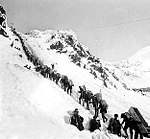
|
Yukon | 2023 | 1564; iv (cultural) | The discovery of gold and the subsequentgold rushat the end of the 19th century brought tens of thousands of prospectors to Klondike (a historical photo fromChilkoot Passin 1898 is pictured). The interactions between the newcomers and the indigenous Tr’ondëk Hwëch’in people resulted in a uniquecultural landscapewith camps, towns, and mining infrastructure.[28][29] |
| Anticosti | 
|
Quebec | 2023 | 1686; viii (natural) | The fossil assemblies at Anticosti Island date from the lateOrdovicianto earlySilurianperiods, 450 to 435 million years ago. They offer an exceptional insight in the succession of marine life over 15 million years, including the near disappearance of marine species in theLate Ordovician mass extinction.[30][31] |
Tentative list[edit]
In addition to sites inscribed on the World Heritage List, member states can maintain a list of tentative sites that they may consider for nomination. Nominations for the World Heritage List are only accepted if the site was previously listed on the tentative list.[32]Canada lists 10 properties on its tentative list.[3]
| Site | Image | Location | Year listed | UNESCO criteria | Description |
|---|---|---|---|---|---|
| Gwaii Haanas |  |
British Columbia | 2004 | iii, v, vi, vii, ix, x (mixed) | This nomination comprises parts of theHaida Gwaiiarchipelago. It includes theSG̱ang GwaayWorld Heritage Site, two otherHaidavillages, and natural areas. The islands are covered by old-growthtemperate rainforest(example pictured) and surrounded by the sea which is home toporpoise,orca,andsea lion.The islands are also an important stopover for migratory birds.[33] |
| Ivvavik/Vuntut/Herschel Island(Qikiqtaruk) |  |
Yukon | 2004 | iv, v, vii, viii, x (mixed) | Two national parks (Vuntut pictured) and an arctic island are rich in wildlife. They are home to three species of bear,Dall sheep,moose,and large herds ofcaribou.This is the home of theInuvialuitand Vuntut people. As the area was not glaciated during theLast Glacial Maximum,it formed a part of theBeringialand bridge, with numerous archaeological assemblies testifying thesettlement of the Americas.[34] |
| Quttinirpaaq |  |
Nunavut | 2004 | iii, vii, viii, x (mixed) | Encompassing the northernmost part of Canada, the park comprises mountains, glaciers, ice shelves, and fyords. The polar desert supports populations ofmuskox,arctic hare,wolf,andPeary caribou.As demonstrated by the archaeological sites, the area has been occupied by different cultures for over four millennia, including thepre-Dorset,DorsetandThule people.[35] |
| Hecate Strait and Queen Charlotte Sound Glass Sponge Reefs Marine Protected Area | 
|
British Columbia | 2018 | viii, ix, x (natural) | Sponge reefswere common in theJurassicandCretaceousperiods but are now rare. The reefs inHecate StraitandQueen Charlotte Soundare considered to be the world's largest living reefs of that type. The sponge colonies are estimated to be 9,000 years old. The reefs provide shelter to juvenile fish on otherwise featureless seabed. Acloud spongeis pictured.[36] |
| Qajartalik | Quebec | 2018 | iii (cultural) | Qajartalik is apetroglyphsite of theDorset culture.The Dorset people inhabited the Canadian Arctic until about 1000 CE and they disappeared before the arrival of theThuleInuit.The site contains about 180 carvings that depict human and zoomorphic faces.[37] | |
| Sirmilik National ParkandTallurutiup Imanga (proposed) National Marine Conservation Area | 
|
Nunavut | 2018 | v, ix (mixed) | The landscape in the high Arctic is defined by ice; however,Lancaster Soundis ice-free most of the year. The open water areas at the edge of ice packs,polynyas,provide shelter for marine mammals and birds, and have been integral for the survival of the peoples that have inhabited the area over the last three millennia.[38] |
| Stein Valley | 
|
British Columbia | 2018 | iii, vi (cultural) | Thecultural landscapeof the Stein Valley is connected to theNlakaʼpamuxpeople and their way of life. They relied on the nature for foods, medicines, and materials. There are numerous trail networks, pictogram sites, resource-gathering locations, and sacred sites. The valley prominently features in the Nlakaʼpamux creation stories and oral traditions.[39] |
| Wanuskewin | 
|
Saskatchewan | 2018 | iii (cultural) | Opimihaw Creek (pictured) is a tributary to theSouth Saskatchewan River.Due to its unique topography with deep valleys in otherwise flatprairies,it has been used by theGreat Plainspeoples for over six millennia. The valley was used asbuffalo jump,for habitation, to gather plants, and to access fresh water. There are several archaeological sites in this relatively small area.[40] |
| Yukon Ice Patches | Yukon | 2018 | iii, v (cultural) | The ice patches in Yukon have been first discovered in 1997. They are different thanglaciersas, unlike the latter, they do not move downhill. First Nations peoples were hunting caribou and sheep in the area and the ice has preserved hunting weapons and other tools from otherwise perishable materials, illustrating the technology of these nomadic hunters. The oldest tools have been dated to be about 7,500 years old.[41] | |
| Transatlantic Cable Ensemble (Canada)* | 
|
Newfoundland and Labrador | 2022 | ii, iv (cultural) | This nomination comprises the two termini of the world's first permanenttransatlantic telegraph cable,which revolutionized the long-distance communication. The eastern terminus, the Valentia Transatlantic Cable Station in Ireland, was built in 1868, while the western terminus, the Heart's Content Cable Station (pictured), was finished in 1876. The sites were closed in the 1960s but still preserve a lot of intact original equipment.[42] |
See also[edit]
References[edit]
- ^"The World Heritage Convention".UNESCO World Heritage Centre.Archivedfrom the original on 27 August 2016.Retrieved7 July2019.
- ^"Convention Concerning the Protection of the World Cultural and Natural Heritage".UNESCO World Heritage Centre.Archivedfrom the original on 1 February 2021.Retrieved3 February2021.
- ^abcde"Canada".UNESCO World Heritage Centre.Archivedfrom the original on 16 September 2022.Retrieved14 September2022.
- ^"Report of Rapporteur"(PDF).UNESCO World Heritage Centre.Archived(PDF)from the original on 16 October 2013.Retrieved14 September2012.
- ^"UNESCO World Heritage Centre – The Criteria for Selection".UNESCO World Heritage Centre.Archivedfrom the original on 12 June 2016.Retrieved17 August2018.
- ^"L'Anse aux Meadows National Historic Site".UNESCO World Heritage Centre.Archivedfrom the original on 16 June 2006.Retrieved26 March2023.
- ^"Nahanni National Park".UNESCO World Heritage Centre.Archivedfrom the original on 26 April 2023.Retrieved26 March2023.
- ^"Dinosaur Provincial Park".UNESCO World Heritage Centre.Archivedfrom the original on 26 April 2023.Retrieved26 March2023.
- ^"SGang Gwaay".UNESCO World Heritage Centre.Archivedfrom the original on 15 March 2023.Retrieved26 March2023.
- ^"Head-Smashed-In Buffalo Jump".UNESCO World Heritage Centre.Archivedfrom the original on 18 March 2023.Retrieved26 March2023.
- ^"Wood Buffalo National Park".UNESCO World Heritage Centre.Archivedfrom the original on 23 March 2023.Retrieved26 March2023.
- ^"Canadian Rocky Mountain Parks".UNESCO World Heritage Centre.Archivedfrom the original on 8 October 2020.Retrieved26 March2023.
- ^"Historic District of Old Québec".UNESCO World Heritage Centre.Archivedfrom the original on 28 June 2011.Retrieved26 March2023.
- ^"Gros Morne National Park".UNESCO World Heritage Centre.Archivedfrom the original on 25 March 2023.Retrieved26 March2023.
- ^"Kluane/Wrangell-St. Elias/Glacier Bay/Tatshenshini-Alsek".UNESCO World Heritage Centre.Archivedfrom the original on 24 February 2017.Retrieved5 November2022.
- ^"Extension: Glacier Bay National Park - extension of the Wrangell/St.Elias/Kluane site of Canada-USA (United States of America)".UNESCO World Heritage Centre.Archivedfrom the original on 13 September 2022.Retrieved5 November2022.
- ^"Extension: Tatshenshini-Alsek Provincial Wilderness Park (extension of the Glacier Bay/Wrangell/St. Elias/Kluane site) (Canada/USA)".UNESCO World Heritage Centre.Archivedfrom the original on 4 December 2022.Retrieved5 November2022.
- ^"Waterton-Glacier International Peace Park".UNESCO World Heritage Centre.Archivedfrom the original on 24 February 2017.Retrieved5 November2022.
- ^"Old Town Lunenburg".UNESCO World Heritage Centre.Archivedfrom the original on 29 March 2023.Retrieved26 March2023.
- ^"Miguasha National Park".UNESCO World Heritage Centre.Archivedfrom the original on 15 May 2022.Retrieved5 November2022.
- ^"Rideau Canal".UNESCO World Heritage Centre.Archivedfrom the original on 6 September 2011.Retrieved26 March2023.
- ^"Joggins Fossil Cliffs".UNESCO World Heritage Centre.Archivedfrom the original on 9 May 2023.Retrieved4 May2023.
- ^"Landscape of Grand Pré".UNESCO World Heritage Centre.Archivedfrom the original on 28 October 2020.Retrieved26 March2023.
- ^"Red Bay Basque Whaling Station".UNESCO World Heritage Centre.Archivedfrom the original on 13 April 2023.Retrieved26 March2023.
- ^"Mistaken Point".UNESCO World Heritage Centre.Archivedfrom the original on 9 May 2023.Retrieved4 May2023.
- ^"Pimachiowin Aki".UNESCO World Heritage Centre.Archivedfrom the original on 5 July 2018.Retrieved4 May2023.
- ^"Writing-on-Stone / Áísínai'pi".UNESCO World Heritage Centre.Archivedfrom the original on 23 September 2020.Retrieved4 May2023.
- ^"Tr'ondëk-Klondike".UNESCO World Heritage Centre.Archivedfrom the original on 30 March 2023.Retrieved28 May2023.
- ^"Tr'ondëk-Klondike".UNESCO World Heritage Centre.Archivedfrom the original on 18 September 2023.Retrieved20 September2023.
- ^"Île d'Anticosti"(in French). UNESCO World Heritage Centre.Archivedfrom the original on 28 December 2022.Retrieved28 May2023.
- ^"Anticosti".UNESCO World Heritage Centre.Archivedfrom the original on 20 September 2023.Retrieved20 September2023.
- ^"Tentative Lists".UNESCO World Heritage Centre.Archivedfrom the original on 1 April 2016.Retrieved7 October2010.
- ^"Gwaii Haanas".UNESCO World Heritage Centre.Archivedfrom the original on 6 February 2022.Retrieved28 May2023.
- ^"Ivvavik / Vuntut / Herschel Island (Qikiqtaruk)".UNESCO World Heritage Centre.Archivedfrom the original on 28 December 2022.Retrieved28 May2023.
- ^"Quttinirpaaq".UNESCO World Heritage Centre.Archivedfrom the original on 29 March 2023.Retrieved28 May2023.
- ^"Hecate Strait and Queen Charlotte Sound Glass Sponge Reefs Marine Protected Area".UNESCO World Heritage Centre.Archivedfrom the original on 12 February 2023.Retrieved28 May2023.
- ^"Qajartalik"(in French). UNESCO World Heritage Centre.Archivedfrom the original on 28 December 2022.Retrieved28 May2023.
- ^"Sirmilik National Park and Tallurutiup Imanga (proposed) National Marine Conservation Area".UNESCO World Heritage Centre.Archivedfrom the original on 29 March 2023.Retrieved28 May2023.
- ^"Stein Valley".UNESCO World Heritage Centre.Archivedfrom the original on 28 December 2022.Retrieved28 May2023.
- ^"Wanuskewin".UNESCO World Heritage Centre.Archivedfrom the original on 28 December 2022.Retrieved28 May2023.
- ^"Yukon Ice Patches".UNESCO World Heritage Centre.Archivedfrom the original on 31 January 2023.Retrieved28 May2023.
- ^"Transatlantic Cable Ensemble (Canada)".UNESCO World Heritage Centre.Archivedfrom the original on 4 March 2023.Retrieved28 May2023.


