
Wytham
| Wytham | |
|---|---|
 All Saints' parish church | |
 Wytham Location withinOxfordshire | |
| Population | 131 (2001 census)[1] |
| OS grid reference | SP4708 |
| Civil parish |
|
| District | |
| Shire county | |
| Region | |
| Country | England |
| Sovereign state | United Kingdom |
| Post town | Oxford |
| Postcode district | OX2 |
| Dialling code | 01865 |
| Police | Thames Valley |
| Fire | Oxfordshire |
| Ambulance | South Central |
| UK Parliament | |
| Website | wytham |

Wytham(/ˈwaɪtəm/WY-təm) is a village andcivil parishon theSeacourt Stream,a branch of theRiver Thames,about 3 miles (5 km) northwest of the centre ofOxford.It is just west of the Western By-Pass Road, part of theOxford Ring Road(A34). The nearest village isGodstow.[2][3]Wytham was the northernmost part ofBerkshireuntil the1974 boundary changestransferred it to Oxfordshire.
Etymology
[edit]Wytham derives its name from the Anglo SaxonWitta's Homearound 500 BCE.[4]Thetoponymis first recorded asWihthamaround 957, and comes from theOld Englishfor a homestead or village in a river-bend.[2]
History of the manor
[edit]The manor of Wytham, along withWytham Abbey(not a religious foundation but themanor house) and much of the village, was formerly owned by theEarls of Abingdon.TheChurch of England parish churchofAll Saintswas originally a medieval building[5]but it was extensively rebuilt between 1811[6]and 1812[3]byMontagu Bertie, 5th Earl of Abingdon.The ruins of the formerGodstow Nunnerylie just east of the village.
The 20th century
[edit]In the 1920s, The 9th Earl of Abingdon sold the Wytham Estate – comprising not just the Abbey but most of the houses in the village and approximately 2,500 acres of park, farm and woodland, including Wytham Great Wood – to Colonel Raymond ffennell, who had made a fortune in South Africa and changed his name from Schumacher on arrival in England, and his wife Hope (nee Weigall). DuringWorld War IIthey agreed to take in sixEast Endchildren as part of the evacuee programme. After the war, they gifted the entire Wytham Estate to theUniversity of Oxford– the largest bequest to the University since theMiddle Ages.The Abbey was subsequently sold by the University of Oxford in 1991 and is now in private hands.
Wytham Great Wood
[edit]Wytham Woodsis an area of long-establishedmixed woodlandnoted for its high population ofbadgersand long-term monitoring ofgreat tits.It is on rising ground to the west of the village and covers 1000 acres. The woods are aSite of Special Scientific Interest.[7]The University of Oxford has owned the woods since 1942 and uses them for research inzoologyandclimate change.[8]The University has a field station north of the village. It is claimed to be one of the most researched pieces of woodland in the world.[9]The woods are open to the public by permit which are available on application,[10]for walking but are closed to dogs, horses and bicycles.
A named path within the wood is called the Singing Way. It is aligned with Oxford and got its name becausemonkson pilgrimage fromCirencestertoCanterburywould break into song here as they sighted the town and the end of their day's journey.[11]On 7 October 2017 an Oxfordshire Blue Plaque was unveiled at the Keeper's Hill car park in Wytham Woods, commemorating the bequest of the woods to the University of Oxford in 1942 by Raymond and Hope Ffennell.[12]
Inspector Morse
[edit]Wytham village andWytham Woodshave frequently featured[when?]in the "Inspector Morse"detective novels byColin Dexter,most notably inThe Way Through the Woods.
Gallery
[edit]-
 The centre of Wytham, with the village shop on the left and the White Hart pub on the right
 -
 Keepers Cottage, Wytham Woods, a gift to theUniversity of Oxfordin 1943
 -
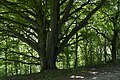 Ancient tree in Wytham Great Wood
 -
 Wytham War Memorial
 -
 Oxford University's John Krebs Field Station, Wytham


References
[edit]- ^"Area selected: Vale of White Horse (Non-Metropolitan District)".Neighbourhood Statistics: Full Dataset View.Office for National Statistics.Retrieved30 March2010.
- ^abMills, A.D.; Room, A. (2003).A Dictionary of British Place-Names.Oxford:Oxford University Press.p. not cited.doi:10.1093/acref/9780199609086.001.0001.ISBN0-19-852758-6.
- ^abPevsner, Nikolaus(1966).Berkshire.The Buildings of England.Harmondsworth:Penguin Books.p. 314.
- ^The Berkshire Book.Reading: The Berkshire Federation of Women's Institutes. 1939. pp. 173–174.
{{cite book}}:CS1 maint: date and year (link) - ^"All Saints Church, Wytham".wytham-church.org.uk.Wytham.
- ^Page, W.H.;Ditchfield, P.H.,eds. (1924).A History of the County of Berkshire, Volume 4.Victoria County History.pp. 427–430.(pages 427-430)
- ^Wytham Woods SSSI citation
- ^Savill, Peter;Perrins, Christopher;Kirby, Keith; Fisher, Nigel (2011).Wytham Woods: Oxford's Ecological Laboratory.Oxford:Oxford University Press.p. 282.doi:10.1093/acprof:osobl/9780199605187.001.0001.ISBN9780199605187.
- ^"About Wytham Woods".University of Oxford.Retrieved5 February2018.
- ^"Walking Permit Application | Wytham Woods".www.wythamwoods.ox.ac.uk.Retrieved5 February2018.
- ^Barkham, Patrick (3 October 2013)."Chapter 2 Meles meles".Badgerlands: The Twilight World of Britain's Most Enigmatic Animal.Granta Publications.ISBN9781847087003.
- ^Oxfordshire Blue Plaques Board: Wytham Woods
External links
[edit] Media related toWythamat Wikimedia Commons
The District of theVale of White Horse | ||
|---|---|---|
| Towns |  | |
| Large villages | ||
| Other civil parishes (component villages and hamlets) |
| |
| Former districts and boroughs | ||
| Former constituencies | ||