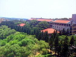
Xiangshan District, Hsinchu
Appearance
Xiangshan
Hương sơn khu | |
|---|---|
 | |
 | |
| Coordinates:24°46′28″N120°55′35″E/ 24.774578°N 120.926487°E | |
| Location | Hsinchu City,Taiwan |
| Government | |
| • Type | District Government |
| Area | |
| • Total | 54.85 km2(21.18 sq mi) |
| Population (September 2023) | |
| • Total | 78,882 |
| Website | dep-s-district |
| Xiangshan District, Hsinchu | |||||||||
|---|---|---|---|---|---|---|---|---|---|
 Xiangshan District office | |||||||||
| Traditional Chinese | Hương sơnKhu | ||||||||
| Simplified Chinese | Hương sơnKhu | ||||||||
| |||||||||
XiangshanorSiangshan Districtis adistrictin southwestHsinchu City,Taiwan.It is the largest of the three districts in Hsinchu City.
History[edit]
Xiangshan was originally atownshipofHsinchu County.On 1 July 1982, the area was incorporated into the newly-formedHsinchu Cityas adistrict.[1]
Geography[edit]
- Area: 54.85 km2(21.18 sq mi)
- Population: 78,882 (September 2023)
Administrative divisions[edit]
The district consists of Gangnan, Hushan, Hulin, Jinshui, Shuxia, Puqian, Zhongpu, Niupu, Dingpu, Tungxiang, Xiangcun, Xiangshan, Dazhuang, Meishan, Zhaoshan, Haishan, Jiadong, Dahu, Nanai, Zhongai, Neihu, Yanshui, Nangang and Dingfu Villages.[2]
Economy[edit]
It is most well known locally for theHsiangshan Industrial Parkand for having the major portion of Hsinchu City's "17 km (11 mi) Scenic Coastline" boardwalk.
Education[edit]
Universities[edit]
Schools[edit]
Tourist attractions[edit]
- Haishan Fishing Port
- Hsiangshan Wetland Natural Park
- Jincheng Lake Bird Watching Zone
- Seafront Scenic Area at Kangnan
Transportation[edit]

- TRAXiangshan Station
- Local buses connect Xiangshan district to other parts of Hsinchu city, Inter-city buses also provide transport toTaipei,TaichungandBanqiao.
Notable natives[edit]
- Lin Chih-chien,Mayor ofHsinchu City
References[edit]
- ^"Brief of City Council".Hsinchu City Council.Retrieved15 April2018.
- ^"2018 Local Elections".Archived fromthe originalon 2018-11-25.Retrieved2023-09-09.
External links[edit]
Wikimedia Commons has media related toXiangshan District, Hsinchu City.
- Official website
 (in English)
