
Xinhe County, Xinjiang
Xinhe County
Toksu, Hsin-ho | |
|---|---|
 Location of Toksu County (red) within Aksu Prefecture (yellow) and Xinjiang | |
 Xinhe County Location of the seat  Xinhe County Xinhe County (China) | |
| Coordinates:41°33′01″N82°37′00″E/ 41.55028°N 82.61667°E | |
| Country | China |
| Autonomous region | Xinjiang |
| Prefecture | Aksu |
| County seat | Toksu Town(Xinhe) |
| Area | |
| • Total | 5,820.46 km2(2,247.29 sq mi) |
| Population (2020)[4] | |
| • Total | 194,473 |
| • Density | 33/km2(87/sq mi) |
| Ethnic groups | |
| • Major ethnic groups | Uyghur[5][6] |
| Time zone | UTC+8(China Standard[a]) |
| Website | xjxinhe |
| Xinhe County, Xinjiang | |||||||||||
|---|---|---|---|---|---|---|---|---|---|---|---|
| Uyghur name | |||||||||||
| Uyghur | توقسۇ ناھىيىسى | ||||||||||
| |||||||||||
| Chinese name | |||||||||||
| Simplified Chinese | Tân hòa huyện | ||||||||||
| Traditional Chinese | Tân hòa huyện | ||||||||||
| |||||||||||
| Alternative Chinese name | |||||||||||
| Simplified Chinese | Thác khắc tô huyện | ||||||||||
| Traditional Chinese | Thác khắc tô huyện | ||||||||||
| |||||||||||
Xinhe County(Chinese:Tân hòa huyện) as the official romanized name, also formerly known as its Uyghur nameToksu County[7](Uyghur:توقسۇ ناھىيىسى;[8]Chinese:Thác khắc tô huyện), is a county inAksu Prefecture,Xinjiang Uyghur Autonomous Region,China.
Name[edit]
The county's original name Toksu was changed into Xinhe in 1941. "Xinhe" is the abbreviation of "XinjiangHeping "(Tân cương hòa bình), literally "Xinjiang Peace."[3][9]
History[edit]
On October 27, 1930, Toksu County was created from part ofKuqa.[3][9]
In 1941[9]or 1944,[3]Toksu County'sChinese charactername was changed from 'Tuokesu' County (Thác khắc tô huyện) to 'Xinhe' County (Tân hòa huyện).
Administrative divisions[edit]
Xinhe County administered 4towns,4townshipsand 4 other areas:[10][2][11]
| Name | Simplified Chinese | Hanyu Pinyin | Uyghur(UEY) | Uyghur Latin (ULY) | Administrative division code | Notes | |
|---|---|---|---|---|---|---|---|
| Towns | |||||||
| Toksu Town (Xinhe Town) |
Tân hòa trấn | Xīnhé Zhèn | توقسۇ بازىرى | toqsu baziri | 652925100 | ||
| Yultuzbaġ Town[12] | Vưu lỗ đô tư ba cách trấn | Yóulǔdūsībāgé Zhèn | يۇلتۇزباغ بازىرى | yultuzbagh baziri | 652925101 | formerly Yultuzbaġ Township (Vưu lỗ đô tư ba cách hương) | |
| Icheriq Town | Y kỳ ngải nhật khắc trấn | Yīqí'àirìkè Zhèn | ئىچئېرىق بازىرى | Ich'ëriq baziri | 652925102 | formerly Icheriq Township (Y kỳ ngải nhật khắc hương) | |
| Tasheriq Town | Tháp thập ngải nhật khắc trấn | Tǎshí'àirìkè Zhèn | تاشئېرىق بازىرى | tash'ëriq baziri | 652925103 | formerly Tasheriq Township (تاشئېرىق يېزىسى/Tháp thập ngải nhật khắc hương) | |
| Payxambabazar Town[13] | Bài tiên bái ba trát trấn | Páixiānbàibāzhā Zhèn | پەيشەنبەبازار بازىرى | peyshenbebazar baziri | 652925104 | formerly Payxambabazar Township (پەيشەنبەبازار يېزىسى/Bài tiên bái ba trát hương) | |
| Üchqat Town | Ngọc kỳ khách đặc trấn | Yùqíkātè Zhèn | ئۈچقات بازىرى | Üchqat baziri | 652925105 | formerly Üchqat Township (ئۈچقات يېزىسى/Ngọc kỳ khách đặc hương) | |
| Townships | |||||||
| Ogen Township | Vị càn hương | Wèigàn Xiāng | ئۆگەن يېزىسى | Ögen yëzisi | 652925203 | ||
| Tamtoghraq Township | Tháp mộc thác cách lạp khắc hương | Tǎmùtuōgélākè Xiāng | تامتوغراق يېزىسى | tamtoghraq yëzisi | 652925205 | ||
Climate[edit]
| Climate data for Xinhe, elevation 1,010 m (3,310 ft), (1991–2020 normals, extremes 1981–2010) | |||||||||||||
|---|---|---|---|---|---|---|---|---|---|---|---|---|---|
| Month | Jan | Feb | Mar | Apr | May | Jun | Jul | Aug | Sep | Oct | Nov | Dec | Year |
| Record high °C (°F) | 7.5 (45.5) |
14.7 (58.5) |
25.5 (77.9) |
34.7 (94.5) |
35.5 (95.9) |
37.7 (99.9) |
40.5 (104.9) |
38.6 (101.5) |
35.7 (96.3) |
29.8 (85.6) |
21.2 (70.2) |
9.9 (49.8) |
40.5 (104.9) |
| Mean daily maximum °C (°F) | −1.0 (30.2) |
5.9 (42.6) |
14.6 (58.3) |
22.8 (73.0) |
27.5 (81.5) |
31.0 (87.8) |
32.3 (90.1) |
31.0 (87.8) |
26.7 (80.1) |
19.9 (67.8) |
10.3 (50.5) |
0.8 (33.4) |
18.5 (65.3) |
| Daily mean °C (°F) | −7.4 (18.7) |
−0.8 (30.6) |
7.9 (46.2) |
15.9 (60.6) |
20.5 (68.9) |
24 (75) |
25.2 (77.4) |
23.9 (75.0) |
19.1 (66.4) |
11.2 (52.2) |
2.6 (36.7) |
−5.0 (23.0) |
11.4 (52.6) |
| Mean daily minimum °C (°F) | −12.7 (9.1) |
−6.6 (20.1) |
1.6 (34.9) |
9.3 (48.7) |
13.8 (56.8) |
17.3 (63.1) |
18.8 (65.8) |
17.6 (63.7) |
12.4 (54.3) |
4.6 (40.3) |
−2.8 (27.0) |
−9.3 (15.3) |
5.3 (41.6) |
| Record low °C (°F) | −24.0 (−11.2) |
−24.2 (−11.6) |
−10.9 (12.4) |
−1.7 (28.9) |
1.4 (34.5) |
6.7 (44.1) |
10.6 (51.1) |
8.1 (46.6) |
3.6 (38.5) |
−4.7 (23.5) |
−14.1 (6.6) |
−23.6 (−10.5) |
−24.2 (−11.6) |
| Averageprecipitationmm (inches) | 2.0 (0.08) |
2.8 (0.11) |
1.4 (0.06) |
2.7 (0.11) |
8.2 (0.32) |
16.8 (0.66) |
13.3 (0.52) |
11.2 (0.44) |
7.1 (0.28) |
3.5 (0.14) |
3.0 (0.12) |
1.7 (0.07) |
73.7 (2.91) |
| Average precipitation days(≥ 0.1 mm) | 2.8 | 1.7 | 0.9 | 1.5 | 2.8 | 6.3 | 7.3 | 6.0 | 3.4 | 1.2 | 1.2 | 2.4 | 37.5 |
| Average snowy days | 5.1 | 2.0 | 0.4 | 0.2 | 0 | 0 | 0 | 0 | 0 | 0 | 1.2 | 4.8 | 13.7 |
| Averagerelative humidity(%) | 70 | 59 | 45 | 38 | 39 | 44 | 49 | 53 | 57 | 60 | 64 | 73 | 54 |
| Mean monthlysunshine hours | 177.6 | 193.4 | 225.5 | 247.5 | 288.0 | 296.5 | 301.9 | 287.1 | 263.5 | 255.5 | 201.2 | 163.4 | 2,901.1 |
| Percentpossible sunshine | 59 | 63 | 60 | 61 | 64 | 65 | 66 | 68 | 72 | 76 | 69 | 58 | 65 |
| Source:China Meteorological Administration[14][15] | |||||||||||||
Economy[edit]
The economy is based on agriculture and also animal husbandry. The county produces wheat, corn, rice, cotton and melons as well as Parthianfenneland thin-shelled walnuts. Industries include wool-spinning, knitting, and carpet making.[3]
Demographics[edit]
| Year | Pop. | ±% p.a. |
|---|---|---|
| 2000 | 139,806 | — |
| 2010 | 172,064 | +2.10% |
| [2] | ||
As of 2015, 184,399 of the 195,920 residents of the county wereUyghur,10,901 wereHan Chineseand 620 were from other ethnic groups.[5]
According to the 2002 census, it has a population of 140,000.[citation needed]
As of 1999, 95.01% of the population of the county were Uyghur and 4.81% of the population was Han Chinese.[16]
Transportation[edit]
Xinhe is served by theSouthern Xinjiang Railway.
Historical maps[edit]
Historical English-language maps including Toksu/Xinhe:
-
![Map including Hsin-ho (Torpak Bazar) and surrounding region from the International Map of the World (AMS, 1950)[b]](https://upload.wikimedia.org/wikipedia/commons/thumb/9/93/A-k%60o-su_NK-44_%281950%29_-_panoramio.jpg/230px-A-k%60o-su_NK-44_%281950%29_-_panoramio.jpg) Map including Hsin-ho (Torpak Bazar) and surrounding region from theInternational Map of the World(AMS,1950)[b]
Map including Hsin-ho (Torpak Bazar) and surrounding region from theInternational Map of the World(AMS,1950)[b] -
 Map including Xinhe (DMA,1981)
 -
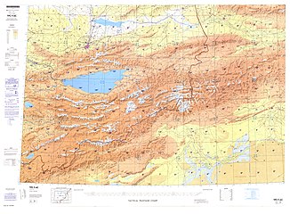
![From the Operational Navigation Chart; map including Hsin-ho (Toksu) (DMA, 1985)[c]](https://upload.wikimedia.org/wikipedia/commons/thumb/7/7e/Operational_Navigation_Chart_F-6%2C_6th_edition.jpg/331px-Operational_Navigation_Chart_F-6%2C_6th_edition.jpg)
![Map including Hsin-ho (Torpak Bazar) and surrounding region from the International Map of the World (AMS, 1950)[b]](/translate/en.wikipedia.org?u=https%3A%2F%2Fen.wikipedia.org%2Fwiki%2FFile%3AA-k%2560o-su_NK-44_%281950%29_-_panoramio.jpg&t=hv)

![From the Operational Navigation Chart; map including Hsin-ho (Toksu) (DMA, 1985)[c]](/translate/en.wikipedia.org?u=https%3A%2F%2Fen.wikipedia.org%2Fwiki%2FFile%3AOperational_Navigation_Chart_F-6%2C_6th_edition.jpg&t=hv)
Notes[edit]
- ^Locals in Xinjiang frequently observeUTC+6(Xinjiang Time), 2 hours behind Beijing.
- ^From map: "THE DELINEATION OF INTERNATIONAL BOUNDARIES ON THIS MAP MUST NOT BE CONSIDERED AUTHORITATIVE"
- ^From map: "The representation of international boundaries is not necessarily authoritative."
References[edit]
- ^Tân hòa huyện huyện tình giản giới.A khắc tô chính phủ võng(in Simplified Chinese). 26 April 2020.Retrieved8 June2020.
- ^abcTân hòa huyện lịch sử duyên cách[Toksu County Historical Development] (in Simplified Chinese). XZQH.org. 30 January 2015.Retrieved31 May2019.
2003 niên, tân hòa huyện tổng diện tích 5830.99 bình phương thiên mễ,
- ^abcdeHạ chinh nông; trần chí lập, eds. (September 2009).Từ hải: Đệ lục bản thải đồ bổn[Cihai(Sixth Edition in Color)] (in Chinese). Thượng hải.Shanghai:Thượng hải từ thư xuất bản xã.Shanghai Lexicographical Publishing House.p. 2542.ISBN9787532628599.
1944 niên cải tân hòa huyện {...}5831 bình phương thiên mễ
- ^Xinjiang: Prefectures, Cities, Districts and Counties
- ^ab3-7 các địa, châu, thị, huyện ( thị ) phân dân tộc nhân khẩu sổ(in Simplified Chinese).شىنجاڭ ئۇيغۇر ئاپتونوم رايونىTân cương duy ngô nhĩ tự trị khu thống kế cụcStatistic Bureau of Xinjiang Uygur Autonomous Region.Archivedfrom the original on 2017-10-11.Retrieved2017-09-03.
- ^1997 niên tân hòa huyện hành chính khu hoa.XZQH.org.10 November 2010.Retrieved8 June2020.
A khắc tô địa khu hạt huyện. Vị vu thiên sơn nam lộc, tháp lí mộc bồn địa bắc duyên. Vi cổ ti trù chi lộ đích tất kinh chi địa. Diện tích 8223 bình phương thiên mễ, nhân khẩu 12.5 vạn, kỳ trung duy ngô nhĩ tộc chiêm 95.5%,
- ^Shohret Hoshur;Joshua Lipes (23 August 2010)."More Arrests in Aksu Blast".Radio Free Asia.Translated by Shohret Tursun; Luisetta Mudie.Retrieved8 June2020.
An official who answered the phone at the Toksu county government office, east of Aksu, denied the bombing existed.
- ^توقسۇ (Variant Non-Roman Script - VS)atGEOnet Names Server,United States National Geospatial-Intelligence Agency
- ^abcLịch sử duyên cách.Tân hòa huyện nhân dân chính phủ(in Simplified Chinese). 29 April 2014. Archived fromthe originalon 11 May 2015 – viaInternet Archive.
- ^Hành chính khu hoa.توقسۇTân hòa huyện nhân dân chính phủ(in Simplified Chinese). Archived fromthe originalon 31 May 2020.Retrieved31 May2020.
- ^2019 niên thống kế dụng khu hoa đại mã hòa thành hương hoa phân đại mã: Tân hòa huyện[2019 Statistical Area Numbers and Rural-Urban Area Numbers: Toksu City] (in Simplified Chinese).National Bureau of Statistics of the People's Republic of China.2019.Retrieved31 May2019.
Thống kế dụng khu hoa đại mã danh xưng 652925100000 tân hòa trấn 652925101000 vưu lỗ đô tư ba cách trấn 652925102000 y kỳ ngải nhật khắc trấn 652925103000 tháp thập ngải nhật khắc trấn 652925201000 bài tiên bái ba trát hương 652925203000 vị càn hương 652925204000 ngọc kỳ khách đặc hương 652925205000 tháp mộc thác cách lạp khắc hương 652925300000 ương tháp khố đô phiến khu quản ủy hội hương 652925500000 tân hòa huyện khinh công nghiệp viên khu sinh hoạt khu 652925502000 tân hòa huyện vật lưu viên khu sinh hoạt khu 652925503000 tân hòa huyện tân tài liêu viên khu sinh hoạt khu
- ^Zhong XingqiChung hưng kỳ,ed. (July 2008).Tây vực địa danh khảo lục(in Simplified Chinese).Beijing:Quốc gia đồ thư quán xuất bản xã.p. 1125.ISBN978-7-5013-3628-9.
Vưu lỗ đô tưyóu lǔ dū sī Yultuzbaġ hương danh. Tân cương tân hòa huyện vưu lỗ đô tư ba cách hương, hương chính phủ trú địa tại huyện thành tây nam 17 công lí. 1990 niên diệp tiên ba trát hương vi vưu lỗ đô tư ba cách hương.
- ^Payxambabazar (Approved - N)atGEOnet Names Server,United States National Geospatial-Intelligence Agency
- ^Trung quốc khí tượng sổ cư võng – WeatherBk Data(in Simplified Chinese).China Meteorological Administration.Retrieved10 October2023.
- ^ Trung quốc khí tượng sổ cư võng(in Simplified Chinese).China Meteorological Administration.Retrieved10 October2023.
- ^Morris Rossabi,ed. (2004).Governing China's Multiethnic Frontiers(PDF).University of Washington Press.p. 179.ISBN0-295-98390-6.
| International | |
|---|---|
| National | |
ThisXinjianglocation article is astub.You can help Wikipedia byexpanding it. |