
Yaoundé
Yaoundé | |
|---|---|
Yaoundé skyline Caisse Nationale de Prévoyance Sociale building Ministère de l'éducation headquarter Musée National du Cameroun Centre Pasteur | |
 Coat of arms | |
| Nickname: La Ville aux Sept Collines | |
 Yaoundé Map of Cameroon showing the location of Yaoundé  Yaoundé Yaoundé (Africa) | |
| Coordinates:3°52′N11°31′E/ 3.867°N 11.517°E | |
| Country | |
| Region | Centre |
| Department | Mfoundi |
| Area | |
| •Capital city | 180 km2(70 sq mi) |
| Elevation | 726 m (2,382 ft) |
| Population (2015 Projection)[1] | |
| •Capital city | 2,765,600 |
| • Density | 15,000/km2(40,000/sq mi) |
| •Metro | 4,681,768 |
| Time zone | UTC+01:00(West Africa Time) |
| • Summer (DST) | (Not Observed) |


Yaoundé(UK:/jɑːˈʊndeɪ,-ˈuːn-/;[2]US:/ˌjɑːʊnˈdeɪ/,French pronunciation:[ja.unde]) is thecapitalofCameroonand, with a population of more than 2.8 million, the second-largest city in the country after the port cityDouala.It lies in theCentre Regionof the nation at an elevation of about 750 metres (2,500 ft) abovesea level.
The outpost ofEpsumborJeundowas founded between theNyongandSanagariversat the northern edge of the area's forests in 1887 by German explorers as a trading base for rubber and ivory. A military garrison was built in 1895 which enabled further colonization. After Imperial Germany's defeat inWorld War I,Franceheldeastern Cameroonas amandate,and Yaoundé was chosen to become the capital of the colony in 1922.[3]
Doualaremained the more important settlement, but Yaoundé saw rapid growth and continued as the seat of government for theRepublic of Cameroonupon its independence in 1960. Most of Yaoundé's economy is still centred on the administrative structure but major industries in Yaoundé includetobacco,dairyproducts, beer,clay,glassgoods andtimber.The city has many striking monuments and buildings, such as the Presidential Palace and Palais des Congrès.
History
[edit]
The earliest inhabitants of Cameroon were likely theBakas (pygmies).They still inhabit the forests of the south and east regions. Bantu speakers originating in the Cameroonian highlands were among the first groups to move out before other invaders. During the late 1770s and early 1800s, theFulani—a pastoral Islamic people of the western Sahel—conquered most of what is now northern Cameroon, subjugating or displacing its largely non-Muslim inhabitants.
The outpost ofEpsumborJeundowas founded between theNyongandSanagariversat the northern edge of the area's forests in 1887,[4]1888,[5][6]or February 1889 by theGermanexplorers Lt. Richard Kund andHans Tappenbeckby the agreement of the chiefs of Ela Esono.[8]From December 1889 to May 1895, it was occupied by theGermanbotanistGeorg August Zenkeras an agricultural research station namedJaundeafter the localYaundeor Ewondo people.[9]His settlement served as a base for the area'srubberandivory trade,purchasing these from the natives in exchange for importedclothingandiron.[6]It was also known in English asYaunde Station.Major Dominik's establishment of a military garrison at the site in 1895 permitted aPallotine missionand religious school at nearbyMvolyé(now a suburb).[6]
DuringWorld War I,Jaunde was occupied byBelgian troopsfrom theCongo.After Imperial Germany's defeat in that war,Franceheldeastern Cameroonas amandateof theLeague of Nationsand Yaoundé was chosen to become the capital of the colony in 1922.[3] Doualalong remained the more important settlement, but Yaoundé saw rapid growth after 1957 due to the cocoa crisis and unrest along the coast. It continued as the seat of government for theRepublic of Cameroonupon its independence.
Economy
[edit]Most of Yaoundé's economy is centred on the administrative structure of the civil service and the diplomatic services. Owing to these high-profile central structures, Yaounde has a higherstandard of livingand security than the rest of Cameroon.
Major industries in Yaoundé includetobacco,dairyproducts, beer,clay,glassgoods andtimber.It is also a regional distribution centre forcoffee,cocoa,copra,sugar caneandrubber.
Local residents engage in urban agriculture. The city is estimated to have "50,000 pigs and over a million chickens."[10]
In 2010, under Mayor Jean Claude Adjessa Melingui, Yaoundé began a flood reduction project, the Yaoundé City Sanitation Master Plan, to deal with "severe floods [that] disrupted the city 15 to 20 times a year, affecting as many as 100,000 people at a time." After four years, the frequency of flooding had been reduced from fifteen to three times a year, and cases of water-borne diseases such astyphoidandmalariawere reduced by almost half. Although Melingui died in 2013, local officials are continuing his efforts to transform the city. Ongoing improvements to sanitation infrastructure are being carried out under a "$152 million plan, largely financed by loans, primarily from theAfrican Development Bankand theFrench Development Agency",slated for completion in 2017.[10]
Despite the security issues and humanitarian crises that have plagued the central African nation, its economy remains stable. In fact, there is diversification of its productive economic activities, with the services sector contributing about half of the total domestic production.[11]However, like many African countries, Cameroon has long suffered from corruption, which dominates almost all the sectors, particularly in the capital city. Oil, gas and mining revenues are rarely reported, which implies massive graft.[12]In addition, there is weak protection of real and intellectual property, and the judicial system is vulnerable to political manipulation.
According to Yaoundé City Council data, over 130 floods struck the city between 1980 and 2014, causing massive loss of life and economic damage. However, there has been a reduction of flooding in the city since the establishment of a sanitation master plan to address the issue.[13]Another measure was to relocate people living along the drainage routes and in low-lying flood zones.
Architecture
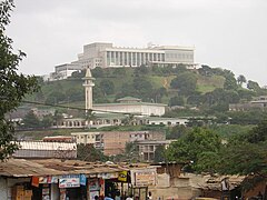
[edit]The city centre houses government offices, some hotels, and the central market. The Bastos district, with most homes owned by Cameroonians, is home to foreign embassies and the expatriate European, American and other continental communities (drawn mainly from the diplomatic corps). The presidential palace and compound are in the Etoudi district.
Also found in Yaoundé are:
- theReunification Monument
- theSport Palace(Palais des Sports)
- Palais des Congrès
There is a small zoo in theMvog-Betsineighbourhood. Yaoundé has a small assortment of Pubs, nightclubs and restaurants. A distance outside Yaoundé is the NGOApe Action Africa,which rescues and rehabilitates Great Apes threatened with extinction by the illegal bushmeat and deforestation trades.
-
 A roundabout near the Place du 20 Mai
 -
 Buses in Yaoundé
 -
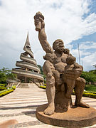 Reunification Monumentand Statue
 -
 Yaoundé Unity Palace – Cameroon Presidency
 -
 Cameroon National Museum
 -

-
 Palais des Congrès
 -
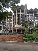 The Ministry of Finance
 -
 The Central Market
 -
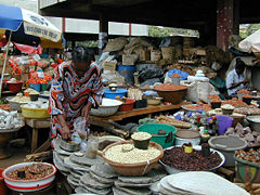 Mfoundi market
 -
 A view of a Yaoundé suburb
 -
 Independence square Cameroon


Culture
[edit]- the Cameroon Art Museum (located in a formerBenedictinemonastery)
- the Cameroon National Museum (located in the former presidential palace)
- theBlackitude Museum
- the Afhemi Museum
- The Yaoundé Municipal Lake
- The Mvog-Betsi Zoo-Botanic Park
- The Congress Centre in Tsinga
Places of worship
[edit]
Theplaces of worshipin the city are predominantlyChristianchurches:Roman Catholic Archdiocese of Yaoundé(Catholic Church), Christian Missionary Fellowship International and Associated Churches (Pentecostal),Evangelical Church of Cameroon(World Communion of Reformed Churches),Presbyterian Church in Cameroon(World Communion of Reformed Churches),Union of Baptist Churches in Cameroon(Baptist World Alliance), Full Gospel Mission Cameroon (Assemblies of God).[14]There are alsoMuslimmosques.
Climate
[edit]Yaoundé features atropical wet and dry climate(Aw), and it is thermally equatorial rather than tropical, with a narrow range of monthly temperatures throughout the year. However, primarily due to the altitude, temperatures are not quite as hot as one would expect for a city located near the equator. Yaoundé features a lengthywet season,covering a ten-month span between March and November. However, there is a noticeable decrease in precipitation within the wet season, seen during the month of July, almost giving the city the appearance of having two separate rainy seasons; this is because the city is only slightly north of the equator. It is primarily due to the relative lull in precipitation during this month that Yaoundé features a tropical wet and dry climate, as opposed to atropical monsoon climate.
| Climate data for Yaoundé | |||||||||||||
|---|---|---|---|---|---|---|---|---|---|---|---|---|---|
| Month | Jan | Feb | Mar | Apr | May | Jun | Jul | Aug | Sep | Oct | Nov | Dec | Year |
| Record high °C (°F) | 33 (91) |
33 (91) |
33 (91) |
36 (97) |
34 (93) |
32 (90) |
31 (88) |
34 (93) |
31 (88) |
33 (91) |
32 (90) |
32 (90) |
36 (97) |
| Mean daily maximum °C (°F) | 29.6 (85.3) |
31.0 (87.8) |
30.4 (86.7) |
29.6 (85.3) |
28.8 (83.8) |
27.7 (81.9) |
26.5 (79.7) |
26.5 (79.7) |
27.5 (81.5) |
27.8 (82.0) |
28.1 (82.6) |
28.5 (83.3) |
28.5 (83.3) |
| Daily mean °C (°F) | 24.6 (76.3) |
25.7 (78.3) |
25.4 (77.7) |
25.0 (77.0) |
24.5 (76.1) |
23.8 (74.8) |
23.2 (73.8) |
22.9 (73.2) |
23.4 (74.1) |
23.5 (74.3) |
23.9 (75.0) |
24.0 (75.2) |
24.2 (75.6) |
| Mean daily minimum °C (°F) | 19.6 (67.3) |
20.3 (68.5) |
20.3 (68.5) |
20.3 (68.5) |
20.2 (68.4) |
19.9 (67.8) |
19.9 (67.8) |
19.3 (66.7) |
19.3 (66.7) |
19.2 (66.6) |
19.6 (67.3) |
19.5 (67.1) |
19.8 (67.6) |
| Record low °C (°F) | 14 (57) |
15 (59) |
16 (61) |
15 (59) |
16 (61) |
15 (59) |
16 (61) |
16 (61) |
15 (59) |
15 (59) |
17 (63) |
16 (61) |
14 (57) |
| Averageprecipitationmm (inches) | 19.0 (0.75) |
42.8 (1.69) |
124.9 (4.92) |
171.3 (6.74) |
199.3 (7.85) |
157.1 (6.19) |
74.2 (2.92) |
113.7 (4.48) |
232.3 (9.15) |
293.6 (11.56) |
94.3 (3.71) |
18.6 (0.73) |
1,541.1 (60.69) |
| Average precipitation days(≥ 0.1 mm) | 3 | 4 | 12 | 14 | 17 | 14 | 11 | 12 | 20 | 23 | 11 | 3 | 144 |
| Averagerelative humidity(%) | 79.5 | 79.5 | 81.0 | 82.0 | 84.0 | 85.0 | 85.5 | 86.0 | 85.5 | 85.0 | 82.0 | 79.0 | 82.8 |
| Mean monthlysunshine hours | 172.0 | 179.0 | 169.9 | 164.5 | 166.2 | 126.0 | 96.1 | 86.2 | 102.4 | 130.2 | 167.1 | 181.4 | 1,741 |
| Source 1:World Meteorological Organization[15]NOAA (sun 1961–1990)[16] | |||||||||||||
| Source 2: BBC Weather[17] | |||||||||||||
Transport
[edit]Two trans-African automobile routes pass through Yaoundé:
Many bus companies operate from the city; particularly in the Nsam and Mvan districts.[18]Frequent buses run on the road between Yaoundé and Douala, which has witnessed several fatal accidents. Travel time by road between Douala and Yaounde is approximately 3 hours. Traffic in the city can be heavy during weekdays, but is very light during the weekends. Yaoundé has made significant progress in infrastructure, especially road construction.
Yaoundé Nsimalen International Airportis a major civilian hub, while nearbyYaoundé Airportis used by the military.
Train linesrun west to the port city ofDoualaand north toN'Gaoundéré.
Education
[edit]Cameroon is a bilingual country, where English and French are both official languages; therefore in the city there is a coexistence of French educational system schools, where the degree giving access to university is theBaccalaureate,and all the education is in French, and the English educational system schools, where the degree giving access to university is theGCEAdvanced level.
There are three American schools in Cameroon, theAmerican School of Yaounde(ASOY) and Rain Forest International School (RFIS), and theAmerican School of Douala(ASD). There is also one Turkish School, The Amity College/School.
Yaoundé is the site of several universities: theUniversity of Yaoundé II(on a campus outside of town), the Protestant University of Central Africa (UPAC) and theCatholic University of Central Africa(UCAC). Several of the nation's professional schools are also located in Yaounde (Higher Teacher's training college, École Militaire InterArmes du Cameroun) as well as various schools for Engineers (Polytech), Doctors (CUSS), Nurses and Diplomats.
Healthcare
[edit]The largest hospital is theCentral Hospital of Yaoundé(Hôpital Central de Yaoundé) with 650 beds.[19]Yaoundé General Hospital(Hôpital Général de Yaoundé– HGY) had 302 beds when it was built in 1985.[20]Other hospitals are theYaoundé Gynaecology, Obstetrics and Pediatrics Hospital(Hôpital Gynéco-Obstétrique et Pédiatrique de Yaoundé– HGOPY) and theUniversity Hospital Center of Yaoundé(Centre Hospitalier Universitaire de Yaoundé– CHU).
Sports
[edit]
The nationalfootballteam plays some of its home matches in theAhmadou Ahidjostadium and the football clubsCanon Yaoundé,Impôts FCandTonnerre Yaoundéare all based in the city. TheGrand Prix Chantal Biya,a men'sroad bicycle racingevent on theUCI Africa Tour,starts and finishes in Yaoundé.
Yaoundé is also the base for the National Institute of Youth and Sport (INJS); this school trains government workers who will be in charge of sport all across the country during their career.
Joel Embiid,center for thePhiladelphia 76ers,andLuc Mbah a Moute,who was a forward for theLos Angeles Clippersare from Yaoundé, as areSamuel Umtiti,a footballer for thenational team of FranceandFC Barcelona,Breel Embolo,a footballer forAS Monaco FCandVincent Aboubakar,a footballer forPorto.
Notable people
[edit]- Pierre Hervé Ateme Elanga,Cameroonian former professional footballer
- Jean-Pierre Bekolo,born in Yaoundé, film director
- Jeanne-Louise Djanga,poet, novelist and choreographer
- Arnold Ebiketie,outside linebackerfor theAtlanta Falcons
- Joel Embiid,Professional basketball player,Philadelphia 76ers
- Breel Embolo,Swiss professional footballer
- Jeando Fuchs,born in Yaoundé professional footballer for English clubPeterborough United.
- Charles Minlend,professional basketball player, 2003Israeli Basketball Premier League MVP
- Francis Ngannou,UFCHeavyweight Champion
- Achille Njanke,Cameroonian footballer
- Ngando Pickett,Cameroonian football fan
- Youssoufa Moukoko,German Professional footballer
- Samuel Umtiti,French Professional footballer
References
[edit]- ^"Cameroon: Regions, Major Cities & Towns - Population Statistics, Maps, Charts, Weather and Web Information".
- ^Jones, Daniel(2003) [1917], Peter Roach; James Hartmann; Jane Setter (eds.),English Pronouncing Dictionary,Cambridge: Cambridge University Press,ISBN3-12-539683-2
- ^abBritannica, Yaoundé,britannica.com, USA, accessed on July 7, 2019
- ^Yaw Oheneba-Sakyi & al.African Families at the Turn of the 21st Century,p. 175.Praeger Publishers (Westport), 2006.ISBN0275972747.Accessed 17 Apr 2014.
- ^Roman Adrian Cybriwsky,Capital Cities around the World: An Encyclopedia of Geography, History, and Culture,ABC-CLIO, USA, 2013, p. 342
- ^abcJohnson–Hans, Jennifer.PA34Uncertain Honor: Modern Motherhood in an African Crisis,p. 34.University of Chicago Press (Chicago), 2006.ISBN0226401812.Accessed 17 Apr 2014.
- ^Kund, Richard.Letter to the Foreign Office of April 4, 1889. Bundesarchiv R 1001/3268, Bl. 14f.(in German)
- ^„Ich bemerke nur, daß der Lieutenant Tappenbeck und ich eine Station in größeren Maßstabe auf dem Innerafrikanischen Plateau zwischen den Flüssen Yong u Zannaga an dem Platze angelegt haben, der auf der Karte mit dem Namen Epsumb bezeichnet ist. (3° 48' N.) Die Entfernung von der Küste beträgt 20 Tagesmärsche... “[7]
- ^Kund and Tappenbeck had used the title "Jaunde" to refer to the area but not the settlement or site itself.
- ^ab"Cameroon: Taming Waters for Health, Jobs in Yaounde".AllAfrica.December 1, 2014.RetrievedJanuary 8,2015.
- ^"2016 Index of Economic Freedom".Heritage.Retrieved4 November2016.
- ^"Corruption in Cameroon".Friedrich-Ebert-Stiftung, 1999.
- ^Nfor, Monde Kingsley (7 August 2015)."Cameroon's Cities Tackle Flood Risk".United Nations International Strategy for Disaster Reduction.Retrieved4 November2016.
- ^J. Gordon Melton, Martin Baumann, ‘‘Religions of the World: A Comprehensive Encyclopedia of Beliefs and Practices’’, ABC-CLIO, USA, 2010, p. 484-486
- ^"World Weather Information Service - Yaounde".World Meteorological Organization.RetrievedDecember 7,2012.
- ^"Yaounde Climate Normals 1961–1990".National Oceanic and Atmospheric Administration.RetrievedSeptember 10,2015.
- ^"Average Conditions Yaounde, Cameroon".BBC Weather.RetrievedDecember 7,2012.
- ^Ben West (2011).Cameroon(3 ed.). Bradt Travel Guides.ISBN978-1-84162-353-5.
- ^"Overview".Central Hospital of Yaoundé. Archived fromthe originalon July 10, 2012.RetrievedJuly 26,2012.
- ^Binder, Georges (1 March 2001).Montois Partners: Selected and Current Works.Images Publishing. p. 126.ISBN978-1-86470-069-5.
Bibliography
[edit]External links
[edit]
| Lekié |  | |
|---|---|---|
| Haute-Sanaga | ||
| Mbam-et-Inoubou | ||
| Mbam-et-Kim | ||
| Méfou-et-Afamba | ||
| Méfou-et-Akono | ||
| Mfoundi | ||
| Nyong-et-Kéllé | ||
| Nyong-et-Mfoumou | ||
| Nyong-et-So'o | ||
| International | |
|---|---|
| National | |
| Geographic | |
| Other | |