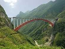
Zhijing River Bridge
Appearance
Zhijing River Bridge Chi tỉnh hà đại kiều | |
|---|---|
 | |
| Coordinates | 30°37′33″N110°11′48″E/ 30.625846°N 110.196594°E |
| Carries | |
| Crosses | Zhijinghe River |
| Locale | Badong County,Hubei,China |
| Official name | Zhijinghe Daqiao |
| Characteristics | |
| Design | Arch |
| Material | Steel |
| Longest span | 430 m (1,410 ft) |
| Clearance below | 294 m (965 ft) |
| History | |
| Opened | November 28th, 2009 |
| Location | |
 | |
Zhijing River Bridgewas thehighestarch bridgein the world upon its completion in 2009.[1][2]The 294 metres high bridge in theThree Gorgesregion ofChinacarries theG50 Shanghai–Chongqing Expresswayacross the valley of the Zhijing River, a northern tributary of theQing River.With a main span of 430 metres the bridge is also one of the20 longest arch bridges in the world.The bridge is located between thetownsof Yesanguan and Dazhiping inBadong Countyof theEnshi Tujia and Miao Autonomous PrefectureofHubeiProvince. The world's highest bridge theSidu River Bridgeis situated only 20km eastwards along the G50 Shanghai–Chongqing Expressway.
See also
[edit]References
[edit]- ^International Conference on Transportation Engineering, 2009: Proceedings of the Second International Conference, July 25-27, 2009, Southwest Jiaotong University, Chengdu, China.La Fontaine de Siloë. 2009. pp. 1808–1811.ISBN978-0-7844-1039-4.
- ^Zheng, Jielian; Wang, Jianjun."Concrete-Filled Steel Tube Arch Bridges in China".Engineering.4(1): 143–155 – via Elsevier Science Direct.
Hurongxi Expressway Zhijing River Bridge (main span of 430 m, completed in 2009)
