
Zunil
Zunil | |
|---|---|
Municipality | |
 Panorama, 2009 | |
 Zunil Location in Guatemala | |
| Coordinates:14°47′N91°29′W/ 14.783°N 91.483°W | |
| Country | |
| Department | |
| Government | |
| •Mayor | Jose Maria Chaj (2012-2016) |
| Area | |
| • Municipality | 80 km2(30 sq mi) |
| Elevation | 2,076 m (6,811 ft) |
| Population (2018 census)[1] | |
| • Municipality | 14,118 |
| • Density | 180/km2(460/sq mi) |
| •Urban | 10,792 |
| Climate | Cwb |
Zunil(Spanish pronunciation:[suˈnil]) is a town andmunicipalityin theQuetzaltenango departmentofGuatemalawith a surface area of 80 square kilometres (31 sq mi).[2]The town of Zunil is located 9 kilometres (5.6 mi) from the city ofQuetzaltenango,on the bank of theSalamá River.[3]Zunil has an altitude of approximately 2,075 metres (6,808 ft)above mean sea level.[3]The population of the municipality, which is 100% indigenous, was 14,118 at the 2018 census. The inhabitants speakKʼicheʼandSpanish.[2] There are thermal baths with volcanic water around the town, for exampleFuentes GeorginasandAlmolonga.
Religion
[edit]Zunil possesses active worship ofSan Simón(also known asMaximón), a life-sized mannequin representing aMayagod, sitting in a wooden throne, which is moved to a different house every year, and many people visit and leave gifts at his shrine.
Namesakes
[edit]A crateronMars,which may be the source ofMars meteorites,is named after the village.[4]
Gallery
[edit]-
 Indoor market
 -
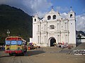 Church in Zunil
 -
 Panorama of Zunil
 -
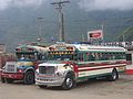 Buses in Zunil


Notes
[edit]- ^Citypopulation.dePopulation of departments and municipalities in Guatemala
- ^abZunil at InforpresscaArchivedJune 6, 2007, at theWayback Machine
- ^abCattelan 2004, p.36.
- ^McEwan, A.S.; et al. (2005)."The rayed crater Zunil and interpretations of small impact craters on Mars"(PDF).Icarus.176(2): 351–381.Bibcode:2005Icar..176..351M.doi:10.1016/j.icarus.2005.02.009.Retrieved2006-09-08..
References
[edit]- Cattelan, Marino (2004).Quetzaltenango.Guatemala: Xibalbá Publicaciones.
External links
[edit]14°47′N91°29′W/ 14.783°N 91.483°W
 Zuniltravel guide from Wikivoyage
- Zunil at Inforpressca
- Fuentes Georginas

| International | |
|---|---|
| National | |
ThisGuatemalalocation article is astub.You can help Wikipedia byexpanding it. |