Colún River
Appearance
40°05′01″S 73°38′31″W / 40.08359°S 73.64204°W
| Colún River | |
|---|---|
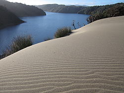
 Dunes and freshwater lagoon at Colún Beach | |
 | |
| Location | |
| Country | Chile |
| Physical characteristics | |
| Source | |
| • location | Cordillera Pelada |
| Mouth | |
• location | Colún Beach |
• elevation | 0 m (0 ft) |
Colún River is a river in La Unión, Chile[1] It is fed by the Yugo Largo, Mañío and El Puente streams at the Colún Hill. The end of the river opens into the Pacific Ocean at Punta Colún, the Colún Beach inside the Valdivian Coastal Reserve.
See also
[edit]References
[edit]- ^ "Colún River". The Nature Conservancy. 2012. Archived from the original on 2014-07-14.
