
Hellmobotn
Village | |
 View of the village | |
 | |
 Hellmobotn  Hellmobotn | |
| Coordinates: 67°48′51″N 16°30′58″E / 67.81406°N 16.51611°E | |
| Country | Norway |
| Region | Northern Norway |
| County | Nordland |
| District | Salten |
| Municipality | Hamarøy Municipality |
| Elevation | 9 m (30 ft) |
| Time zone | UTC+01:00 (CET) |
| • Summer (DST) | UTC+02:00 (CEST) |
| Post Code | 8274 Musken |
Hellmobotn (Norwegian) or Vuodnabahta (Lule Sami)[2] is a village located in Hamarøy Municipality in Nordland county Norway.[3][4] The Hellmofjorden is a fjord that runs through the valley,[5] it is an arm off of main Tysfjorden.[5][6] Hellmobotn is located at the narrowest part of Norway where the seawater in the fjord reaches to a point that is only about 6 kilometres (3.7 mi) from the national border with Sweden.
-
 Hellmobotn seen from the fjord
Credit: Helge Høifødt -
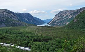 Hellmofjorden and the plateau within Hellmobotn
Credit: Helge Høifødt


References
[edit]- ^ "Hellmobotn". yr.no. Retrieved 2024-09-04.
- ^ "Informasjon om stadnamn". Norgeskart (in Norwegian). Kartverket. Retrieved 2024-09-03.
- ^ "Fra Hellmobotn til Sverige". www.ut.no. Retrieved 2023-07-07.
- ^ Thorsnæs, Geir (2023-01-22). "Hellmobotn". Great Norwegian Encyclopedia (in Norwegian). Retrieved 2023-07-07.
- ^ a b Thorsnæs, Geir (2023-01-22), "Hellmofjorden", Store norske leksikon (in Norwegian), retrieved 2023-07-07,
Den er 33 kilometer lang fra Ytter-Helland til Hellmobotn.
- ^ Centre, UNESCO World Heritage. "The Laponian Area - Tysfjord, the fjord of Hellemobotn and Rago (extension)". UNESCO World Heritage Centre. Retrieved 2023-07-07.
This Nordland location article is a stub. You can help Wikipedia by expanding it. |