B65 (New York City bus)
b65 | |||
|---|---|---|---|
| Bergen Street Line | |||
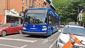
 A 2021 XDE40 (9511) on the B65 to Downtown Brooklyn | |||
| Overview | |||
| System | MTA Regional Bus Operations | ||
| Operator | New York City Transit Authority | ||
| Garage | East New York Depot | ||
| Vehicle | New FlyerXcelsior XD40 New FlyerXcelsior XDE40 OBIOrion VII NG HEV | ||
| Route | |||
| Locale | Brooklyn,New York, U.S. | ||
| Start | Downtown Brooklyn–Fulton Mall/Jay Street–MetroTech station | ||
| Via | Bergen/Dean Streets | ||
| End | Crown Heights– Ralph Avenue | ||
| Length | 3.6 miles (5.8 km) | ||
| Other routes | B45 St. Johns Place | ||
| Service | |||
| Operates | All times except late nights[1] | ||
| Annual patronage | 718,002 (2023)[2] | ||
| Transfers | Yes | ||
| Timetable | B65 | ||
| |||
TheBergen Street Lineis apublic transitline inBrooklyn,New York City,running westbound mostly along Bergen Street, as well as eastbound on Dean Street (as part of aone-way pair), betweenDowntown BrooklynandOcean Hill(earlierRed HooktoCity Line). Originally astreetcar line,it is now theB65bus route,operated by theNew York City Transit Authority.The B65 is based out of theEast New York DepotinEast New York, Brooklyn.
Route description
[edit]The B65 starts at Boerum Place and Joralemon Street. The eastbound route runs down Boerum Place and makes a left at Atlantic Avenue. It runs down Atlantic Avenue to 3rd Avenue and proceeds to make a right turn and run down Third Avenue for two blocks before turning left on Dean Street. The route then proceeds east on Dean Street until it reaches Rochester Avenue and then turns right on Rochester Avenue. The route then takes another left at St. Marks Avenue. It runs down St Marks Avenue until Ralph Avenue where it makes a right turn and runs down Ralph Avenue until St Johns Place, where it terminates along with theB45.
The westbound B65 starts at St Johns Place and runs down St Johns Place for one block and makes a right turn on Buffalo Avenue and runs down Buffalo Avenue until Bergen Street, where it makes a left turn on Bergen Street. It runs down Bergen Street until Smith Street, where it makes a right turn on Smith Street. It then runs up Smith Street until Livingston Street, where it terminates.
History
[edit]
TheSouth Brooklyn and Bergen Street Railroadwas organized under the general railroad law[3]and opened by 1865 from Hamilton Ferry along Sackett Street (including part of theBrooklyn City Rail Road'sFurman Street Line), Hoyt Street, and Bergen Street to Classon Avenue.[4][5]The Bergen Street Railroad was merged into theBrooklyn and Canarsie Railroad,[6]and on September 21, 1866 an extension toCanarsie Landing(wheresteamboatsconnected forRockaway) along Bergen Street,Nostrand Avenue,Clove Road, Little Lane, andCanarsie's main street (the last three partially gone)[7]was opened.[8]It was the second line to Canarsie, arriving a year after theBrooklyn and Rockaway Beach Railroad,and was a failure, beingforeclosedon January 13, 1868. The original portion, west of the stables at Bergen Street and Classon Avenue, was sold on February 14, 1868;[9]the rest was sold on September 15, 1868.[7]None of the extension to Canarsie was ever used again.
TheSouth Brooklyn and Park Railroadacquired the line to Classon Avenue on June 1, 1870,[10]and was again sold on June 19, 1877[11]as theSouth Brooklyn Central Railroad.It was authorized in 1878 to build a branch in Bergen Street from Hoyt Street west to Court Street, use theBrooklyn City Railroadtrackage in Court Street, and use theAtlantic Avenue Railroadtrackage inAtlantic Avenueand Furman Street to the Wall Street Ferry at Montague Street.[12]The Atlantic Avenue Railroad leased the South Brooklyn Central, then extending to Bergen Street and Albany Avenue, on February 2, 1885.[13]The Atlantic Avenue Railroad laid tracks in Boerum Place from Atlantic Avenue south to Bergen Street to connect the lines, as an extension of itsAdams Street and Boerum Place Line.
The line reached Rochester Avenue by 1897.[14]Eventually the Bergen Street Line cars turned south on Buffalo Avenue, east on theSt. Johns Place Linetrackage along St. Johns Place and East New York Avenue, and east alongLiberty AvenuetoCity Line.
At some point, the west end was truncated to the intersection of Smith Street and Sackett Street. Buses were substituted for streetcars on July 20, 1947, and were replaced again by trolley buses between October 17, 1948 and July 27, 1960.[15]The B65 bus has been truncated more, only running from Cobble Hill east to Ocean Hill; the B12 bus, started by theBrooklyn–Manhattan Transit Corporationas a new route in 1931, later covered Liberty Avenue out to City Line until it was truncated to Broadway Junction in 2010.
In the 1990s, the B65 was rerouted from Cobble Hill north to Downtown Brooklyn, terminating at the Fulton Mall.
On December 1, 2022, the MTA released a draft redesign of the Brooklyn bus network.[16][17]As part of the redesign, B65 service west of Washington Avenue would be rerouted to serve Atlantic Avenue with the B45. B65 would also be shortened to Ralph Avenue and St. Marks Place. Service on Bergen and Dean Streets west of Washington Avenue would be discontinued.[18]Closely spaced stops would also be eliminated.[16][17]
References
[edit]- ^MTA Regional Bus Operations."B65 bus schedule".
- ^"Subway and bus ridership for 2023".mta.info.April 29, 2024.RetrievedMay 2,2024.
- ^"Local Legislation",Brooklyn Daily Eagle,April 18, 1863, page 2
- ^"Police Intelligence",Brooklyn Daily Eagle,June 27, 1865, page 3
- ^"Particulars About Our City Rail Roads",Brooklyn Daily Eagle,August 10, 1865, page 2
- ^"Meeting of the Committee on Railroads of the Common Council - The Brooklyn and Canarsie Railroad",Brooklyn Daily Eagle,May 3, 1866
- ^ab"Legal Notices",Brooklyn Daily Eagle,August 8, 1868, page 4
- ^"Travel",Brooklyn Daily Eagle,September 22, 1866, page 4
- ^"New York Supreme Court",Brooklyn Daily Eagle,January 21, 1868, page 4
- ^"Railroad Enterprise",Brooklyn Daily Eagle,October 7, 1870, page 2
- ^"Supreme Court",Brooklyn Daily Eagle,June 4, 1877, page 4
- ^"The Aldermen",Brooklyn Daily Eagle,April 23, 1878, page 2
- ^"In New Hands",Brooklyn Daily Eagle,February 2, 1885, page 4
- ^Rand McNally,Brooklyn and vicinity,1897 Atlas of the World
- ^"Brooklyn Trackless Trolleys".nycsubway.org.RetrievedFebruary 14,2024.
- ^abBrachfeld, Ben (December 1, 2022)."Draft plan for new Brooklyn bus network aims to finally end decades of slow, unreliable service".amNewYork.RetrievedDecember 2,2022.
- ^abSpivack, Caroline (December 1, 2022)."Brooklyn bus riders could finally get faster service under MTA redesign".Crain's New York Business.RetrievedDecember 2,2022.
- ^"Draft Plan: B65 Local".MTA.RetrievedDecember 5,2022.
External links
[edit] Media related toB65 (New York City bus)at Wikimedia Commons

