
Citadel of Erbil
| Erbil Citadel | |
|---|---|
Kurdish:قەڵای هەولێر | |
| Erbil,Kurdistan Region,Iraq | |
 Aerial view of the Erbil citadel | |
 Erbil Citadel | |
| Coordinates | 36°11′28″N44°00′32″E/ 36.191°N 44.009°E |
| Type | Citadel |
| Site information | |
| Controlled by | Kurdistan Region |
| Open to the public | Yes |
| Condition | Partially ruined |
| Site history | |
| Battles/wars | Siege by theMongols(1258) |
| Official name | Erbil Citadel |
| Type | Cultural |
| Criteria | iv |
| Designated | 2014(38thsession) |
| Reference no. | 1437 |
| Region | List of World Heritage Sites in Iraq |
TheErbil Citadel(Kurdish:قەڵای هەولێرQelay Hewlêr,Arabic:قلعة اربيل,romanized:Qal'at Erbīl) locally calledQalat,is atellor occupied mound, and the historical city centre ofErbilin theKurdistan RegionofIraq.[1]The citadel has been included in the World Heritage List since 21 June 2014.
The earliest evidence for occupation of the citadel mound dates to the 5th millennium BC, and possibly earlier. It appears for the first time in historical sources in theEbla tabletsaround 2000 BC, and gained particular importance during theNeo-Assyrianperiod. During theSassanianperiod and theAbbasid Caliphate,Erbil was an important centre forChristianity.After theMongolscaptured the citadel in 1258, the importance of Erbil declined. During the 20th century, the urban structure was significantly modified, as a result of which a number of houses and public buildings were destroyed. In 2007, the High Commission for Erbil Citadel Revitalization (HCECR) was established to oversee therestorationof the citadel. In the same year, all inhabitants, except one family, were evicted from the citadel as part of a large restoration project. Since then,archaeologicalresearch and restoration works have been carried out at and around the tell by various international teams and in cooperation with local specialists. The government plans to have 50 families live in the citadel once it is renovated.
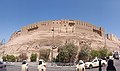
The buildings on top of the tell stretch over a roughly oval area of 430 by 340 metres (1,410 ft × 1,120 ft) occupying 102,000 square metres (1,100,000 sq ft). The only religious structure that currently survives is theMulla AfandiMosque. The mound rises between 25 and 32 metres (82 and 105 ft) from the surrounding plain. When it was fully occupied, the citadel was divided in three districts ormahallas:from east to west the Serai, the Takya and the Topkhana. The Serai was occupied by notable families; the Takya district was named after the homes ofdervishes,which are calledtakyas;and the Topkhana district housed craftsmen and farmers.
History
[edit]Prehistory
[edit]The site of the citadel may have been occupied as early as theNeolithicperiod, aspottery fragmentspossibly dating to that period have been found on the slopes of the mound. Clear evidence for occupation comes from theChalcolithicperiod, with sherds resembling pottery of theUbaidandUrukperiods in theJaziraand southeasternTurkey,respectively.[2]Given this evidence for early occupation, the citadel has been called the oldest continuously occupied town in the world.[1][3]
Earliest historical records
[edit]Erbil appears for the first time in literary sources around 2300 BC in the archives ofEbla.According toGiovanni Pettinato,it is mentioned in two tablets asIrbilum.[4]
The city was first largely under Sumerian domination from c. 3000 BC, until the rise of the Akkadian Empire (2335–2154 BC) which united all of the Akkadian Semites and Sumerians of Mesopotamia under one rule.
Later,Erridupizir,king of Gutium, captured the city in 2200 BC.[5]
At the end of the 3rd millennium BC, Erbil is mentioned in historical records of theUr IIIperiod as Urbilum. KingShulgidestroyed Urbilum in his 43rd regnal year, and during the reign of his successorAmar-Sin,Urbilum was incorporated into the Ur III state. In the 18th century BC, Erbil appears in a list of cities that were conquered byShamshi-Adadof Upper Mesopotamia and Dadusha ofEshnunnaduring their campaign against the land of Qabra. Shamshi-Adad installed garrisons in all the cities of the land of Urbil. During the 2nd millennium BC, Erbil was incorporated intoAssyria.Erbil served as a point of departure for military campaigns toward the east.[6][7]
From the Neo-Assyrian period to the Sassanids
[edit]Erbil was an important city during the Neo-Assyrian period. The city took part in the great revolt againstShamshi-Adad Vthat broke out over the succession ofShalmaneser III.During the Neo-Assyrian period, the name of the city was written asArbi-Ilu,meaning 'Four Gods'. Erbil was an important religious centre that was compared with cities such asBabylonandAssur.Its goddessIshtarof Erbil was one of the principal deities of Assyria, often named together with Ishtar ofNineveh.Her sanctuary was repaired by the kingsShalmaneser I,EsarhaddonandAssurbanipal.Inscriptions from Assurbanipal record oracular dreams inspired by Ishtar of Erbil. Assurbanipal probably held court in Erbil during part of his reign and received there envoys fromRusa IIofUrartuafter the defeat of theElamiteruler Teumman.[6]
After the end of the Assyrian Empire, Erbil was first controlled by theMedesand then incorporated into theAchaemenid Empirebefore it became part of the empire ofAlexander the Greatafter theBattle of Gaugamela,which was fought near Erbil in 331 BC.[8]Subsequently, after the partition of Alexander the Great's Empire by his generals (known as Diadochoi), the city was called Arabella or Arbela and it was part of the Hellenistic Seleucid Kingdom. After the 1st century BCE, theRomanandParthian Empirefought over control of Erbil, or Arbira as it was known in that period. After the 1st century AD, Arbela became an important Christian center. During the Sassanid period, Erbil was the seat of a satrap (governor). In 340 AD, Christians in Erbil were persecuted and in 358, the governor became amartyrafter he converted to Christianity.[9]ANestorianschool was founded in Erbil by theSchool of Nisibisinc.521.[10]During this period, Erbil was also the site of aZoroastrianfire temple.[11]
Muslim conquest until the Ottomans
[edit]
Erbil was conquered by theMuslimsin the 7th century. It remained an important Christian center until the 9th century, when thebishopof Erbil moved his seat toMosul.In the middle of the 10th century, Erbil came under the rule ofHadhabaniKurds until 1063 when it was taken over by theSeljuks.From the first half of the 12th century until 1233, Erbil was the seat of the Begteginids, aTurcomandynasty that rose to prominence under the reign ofZengi,theatabegof Mosul. In 1183, Zain ad-Din Yusuf, ruler of Erbil, shifted his allegiance to theAyyubid Sultanate.In 1190 when Zain ad-Din Yusuf died, his older brotherMuzaffar al-Din Gökböri,who was previously governor ofEdessa,became the new governor of Erbil. He created a lower town around the city on the citadel mound and founded hospitals andmadrasahs.When Gökburi died in 1233 without an heir, control of Erbil shifted to theAbbasid Caliphal-Mustansirafter he had besieged the city.[9][12]
When the Mongolsinvadedthe Near East in the 13th century, they attacked Erbil for the first time in 1237. They plundered the lower town but had to retreat before an approaching caliphal army and had to put off the capture of the citadel.[13]After thefall of BaghdadtoHülegüand the Mongols in 1258, they returned to Erbil and were able to capture the citadel after a siege lasting six months.[14]Hülegü then appointed a Christian governor to the town and there was an influx ofJacobite Christians,who were allowed to build a church.
As time passed, persecutions of Christians, Jews and Buddhists throughout theIlkhanatebegan in earnest in 1295 underOïratamirNauruz.[15]This manifested early on in the reign of theIlkhanGhazan.In 1297, after Ghazan had felt strong enough to overcome Nauruz' influence, he put a stop to the persecutions.
During the reign of the IlkhanÖljeitüsome of the Christian inhabitants retreated to the citadel to escape persecution. In the spring of 1310, theMalek(governor) of the region attempted to seize it from them with the help of the Kurds. DespiteMar Yahballaha's best efforts to avert the impending doom, the citadel was at last taken by Ilkhanate troops on 1 July 1310, and all the defenders were massacred, as were all the Christian inhabitants of the lower town.[9][16]
AfterBattle of Chaldiranin 1514, Erbil came under control ofSoran emirate,a semi-independentEmirateunder theOttomans.In the 18th centuryBaban Emiratetook the city but it was retaken bySoranrulerMirMuhammed Kor in 1822. The Soran emirate continued ruling over Erbil until it was retaken by theOttomansin 1851. Erbil became part of theMusul VilayetinOttoman EmpireuntilWorld War I,when the Ottomans were defeated by theBritish Empire.The town had approximately 3,200 inhabitants, including a sizeableJewishminority.[3]
Modern period
[edit]
During the 20th century, the citadel witnessed significant urban and social changes. A 15-metre (49 ft) high steel water tank was erected on the citadel in 1924, providing the inhabitants with purified water, but also causing water damage to the foundations of the buildings due to increased water seepage. The number of inhabitants gradually declined over the 20th century as the city at the foot of the citadel grew and wealthier inhabitants moved to larger, modern houses with gardens.[17]In 1960, over 60 houses, a mosque, and a school were demolished to make way for a straight road connecting the southern gate with the northern gate.[18]Some reconstruction works were carried out in 1979 on the citadel's southern gate and thehammam.In 2007, the remaining 840 families were evicted from the citadel as part of a large project to restore and preserve the historic character of the citadel. These families were offered financial compensation. One family was allowed to continue living on the citadel to ensure that there would be no break in the possible 8,000 years of continuous habitation of the site, and the government plans to have 50 families live in the citadel once its renovated.[19]In 2004, theKurdish Textile Museumopened its doors in a renovated mansion in the southeast quarter of the citadel.[20]
The Citadel and the Bazaar
[edit]The city of Erbil is defined by the central circular mound that is the citadel, 102,000 square metres of land raised 26 metres above the surrounding city, presumed to have been started in antiquity as a tell. Around and beneath it to the south sprawl a maze of alleyways where the ancient commercial heart of the city beats strongly to this day. The citadel dwellings still stand, although they are now vacated as part of the UNESCO development project to renovate the buildings. Former resident Mahmoud Yasim, who grew up with his seven siblings in the 8000-year-old network of alleyways alongside some 830 other families, describes the community they enjoyed: 'Everyone used to know each other back then. We were living in houses without permission and they were very old and partially collapsed – but our lives were good. We were close to everything – the bazaar, the hospital and schools as well.' A great many of the inhabitants were sad to leave when the authorities relocated them in 1997 – largely to Qalai New (the 'New Citadel') – but it has afforded the opportunity to start work on rebuilding the crumbling structures, restoring wherever possible the intricate plasterwork and distinctively carved lintels. The market area below is thought to have been created in the time of Sultan Muzafferddin Kokberi (1190–1233). This period, the only time in its long history when Erbil flourished as an independent city state, also saw the creation of the minaret recently restored in downtown Erbil, and was also the time when the Muzafferddin madrassahs (schools) were founded.
The area around the southern base of the citadel has received the attention of modern town planners, with the large open-air Lana market where once market stalls sold leather crafts now and replaced by a large modern shopping mall. The covered market, known as Qasariyah, still stands largely unchanged: A labyrinth of small alleyways protected from sun and rain by a latticework of corrugated iron. Beneath these eaves are the numerous shopkeepers selling wares largely imported from the Far East interspersed with craftsmen plying a trade they inherited from their forefathers in the late nineteenth century when the bazaar was restored: Jewellers, cobblers, carpenters, tinsmiths and butchers. Where possible, tradesmen gather alongside others who trade in the same wares, giving each alleyway a specialism such as the passageway towards the north-east corner where honey and dairy products are sold – yoghurts and cheeses piling the highly valued local honey. Another highly prized tradition is the creation of Klash shoes – an ancient uniquely Kurdish craft when white cloth is beaten on small anvils to create hardwearing footwear. These, and the traditional fabrics sold in the textile souk, are ever-popular in the run-up to the annual Newroz celebrations when the townspeople assume traditional attire.[21]
Architecture and layout
[edit]
The citadel is situated on a large tell – or settlement mound – of roughly oval shape that is between 25 and 32 metres (82 and 105 ft) high. The area on top of the mound measures 430 by 340 metres (1,410 ft × 1,120 ft) and is 102,000 square metres (1,100,000 sq ft) large. Natural soil has been found at a depth of 36 metres (118 ft) below the present surface of the mound.[22]Theangleof the citadel mound's slopes isc.45°.[3]Three ramps, located on the northern, eastern and southern slopes of the mound, lead up to gates in the outer ring of houses. The southern gate was the oldest and was rebuilt at least once, in 1860, and demolished in 1960. The current gate house was constructed in 1979. The eastern gate is called the Harem Gate and was used by women. It seems unclear when the northern gate was opened. One source claims that it was opened in 1924,[17]while another observes that there were only two gates in 1944 – the southern and eastern gates.

During the early 20th century, there were threemosques,two schools, twotakyasand a hammam on the citadel.[23]The citadel also housed asynagogueuntil 1957.[22]The only religious structure that currently survives is theMulla AfandiMosque, which was rebuilt on the location of an earlier 19th-century mosque.[24]The hammam was built in 1775 by Qassim Agha Abdullah. It went out of service during the 1970s and was renovated in 1979, although many original architectural details were lost.[22][25]

When it was still occupied, the citadel was divided in three districts ormahallas:from east to west the Serai, the Takya and the Topkhana. The Serai was occupied by notable families; the Takya district was named after the homes ofdervishes,which are calledtakyas;and the Topkhana district housed craftsmen and farmers. A 1920 inventory showed that at that time the citadel was divided into 506 house plots. Since then the number of houses and inhabitants has gradually declined. For example, in 1984 4,466 people lived in 375 houses, whereas a 1995 census showed that the citadel had only 1,631 inhabitants living in 247 houses.[23]Until the opening-up of the main north–south thoroughfare, the streets on the citadel mound radiated outward from the southern gate like the branches of a tree. Streets were between 1 and 2.5 metres (3 ft 3 in and 8 ft 2 in) wide and ranged in length from 300 metres (980 ft) for major alleyways to 30–50 metres (98–164 ft) forcul-de-sacs.[26]

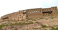
The perimeter wall of the citadel is not a continuous fortification wall, but consists of the façades of approximately 100 houses that have been built against each other. Because they have been built on or near the steep slope of the citadel mound, many of these façades were strengthened bybuttressesto prevent their collapse orsubsidence.[27]There were circa 30 city-palaces; most of them located along the perimeter of the citadel.[28]The oldest surviving house that can be securely dated through an inscription was built in 1893. The oldest houses can be found on the southeastern side of the mound, whereas houses on the northern perimeter date to the 1930s–1940s.[29][30]Before the introduction of modern building techniques, most houses on the citadel were built around a courtyard. A raisedarcadeoverlooking the courtyard, a flat roof and a bent-access entrance to prevent views of the courtyard and the interior of the house were characteristic elements of the houses on the citadel.[28]
Research and restoration
[edit]

In 2006 and 2007, a team from theUniversity of West Bohemia,together withSalahaddin Universityin Arbil, carried out an extensive survey and evaluation of the entire citadel. As part of this project,geodeticmeasurements of the citadel were taken and these were combined withsatellite imagery,regular photographic imagery andaerial photographsto create a map and digital 3D model of the citadel mound and the houses on top of it.Geophysical prospectionwas carried out in some areas of the citadel to detect traces of older architecture buried under the present houses. Archaeological investigations included anarchaeological surveyon the western slope of the citadel mound, and theexcavationof a small test trench in the eastern part of the citadel.[31]
in 2012, the Higher Committee for the Maintenance and Rehabilitation of the Erbil Citadel decided to identify seven areas inside the Citadel to conduct excavations, and to search for the remains of the wall and the historical fortifications of the citadel, the commission chose point E because it is on the northwest edge of the citadel, west of the main gate (Bab Ahmadi), which facilitated the process of finding the historic wall of the citadel. The excavations took place in four seasons 2013-2014-2015 under the chairmanship of Dr. Abdullah Khurshid and many foreign consultants, including Dr. John McCains from Cambridge University in Britain. A part of the citadel wall of Erbil has been discovered, which was not visible, we didn't know much about it only passing references in historical writings, which mentions that the wall was surrounding the citadel, which enabled the inhabitants of the citadel to defend it against the attacks of enemies and invaders.[32]
A Neo-Assyrianchamber tombwas found at the foot of the citadel mound during construction activities in 2008. It was subsequently excavated by the local Antiquities Service and archaeologists from theGerman Archaeological Institute(DAI). The tomb was plundered in antiquity but still contained pottery dating to the 8th and 7th centuries BC.[33]The cooperation between the Antiquities Service and the DAI was continued later that year with a further investigation of the tomb and with a small excavation nearby and geophysical survey of the surrounding area, in which also students from Salahaddin University participated. These investigations revealed the presence of architecture probably dating to the Neo-Assyrian period, as well as more burials belonging to subsequent centuries.[34]

In 2007, theKurdistan Regional Government(KRG) established the High Commission for Erbil Citadel Revitalization (HCECR) to preserve and restore the citadel with the help ofUNESCO.[1]Among other things, the HCECR advocates the establishment of a zone extending up to 300–400 metres (980–1,310 ft) from the citadel in which building height should be restricted to approximately 10 metres (33 ft). This would ensure the visual dominance of the citadel over its surroundings.[35]
On 2 April 2019,NASAhas described the historic citadel as possibly the oldest continuously occupied human settlement on Earth.[36][37]
UNESCO World Heritage status
[edit]On 8 January 2010, the HCECR and the Iraqi State Board for Antiquities and Heritage (SBAH) submitted the Citadel of Erbil to the IraqiTentative Listof sites that are considered for nomination asWorld Heritage Site.The submission states that "The Citadel is today one of the most dramatic and visually exciting cultural sites not only in the Middle East but also in the world."[1]Two further agreements between the HCECR and UNESCO were signed in March 2010, and it was disclosed thatArbil Governoratewill finance the restoration project with US$13 million.[38]The first restoration works were carried out in June 2010.[39]The Citadel was inscribed on the World Heritage List on 21 June 2014. In January 2017, UNESCO indicated that the site could be removed from the list due to the slow progress being made in the restoration program.[40]
Places to visit at the Citadel
[edit]
- The Kurdish Textile and Ethnographic (Cultural) Museum
- The French Institute of the Near East (French:Institut français du Proche-Orient,IFPO)
- Erbil Citadel Cultural Center
- Traditional Hammam (public bath)
- Great Mosque (Mulla Effendi Mosque)
- Erbil Stones and Gems Museum
- Citadel Antiques (souvenirs)
- High Commission for Erbil Citadel Revitalization (HCECR), head office
- Turkmen Heritage House
- Exhibition of Miniature of Kurdistan Costumes
- Kurdistan Music Archive
- Kurdish Tourism Association
- Barzani Museum
- Erbil Citadel Visitor Center
- Erbil Citadel Interpretation Center
- Exhibition of Handmade Carpets
- Mulla Ibrahim Dogramachi Mosque
-
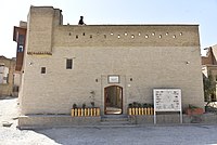
 Erbil Citadel Visitor Center
 -
 Kurdish Textile and Ethnographic (Cultural) Museum
 -
-

-
 The French Institute of the Near East
 -
 Exhibition of Miniature of Kurdistan Costumes (left) andKurdistan Music Archive(right)
 -
 A panoramic photo of Erbil Citadel


Gallery
[edit]Some photos of the Citadel of Erbil during the restoration work, 2014.
-
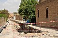
 An alley, Citadel of Erbil, during the restoration work in 2014
 -
 Citadel during the restoration work in 2014. Hawler, Erbil, Kurdistan Region.
 -
 Citadel of Erbil during the restoration work in 2014. Hawler, Erbil, Kurdistan Region.
 -
 Citadel of Erbil during the restoration work in 2014. Hawler, Erbil, Kurdistan Region.
 -
 Citadel of Erbil during the restoration work in 2014. Hawler, Erbil, Kurdistan Region.
 -
 Citadel of Erbil during the restoration work in 2014. Hawler, Erbil, Kurdistan Region.
 -
 Citadel of Erbil during the restoration work in 2014. Hawler, Erbil, Kurdistan Region.
 -
 Wall of the Citadel during the restoration work in 2014. Hawler, Erbil, Kurdistan Region.
 -
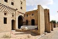
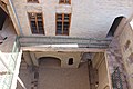
 Courtyard in a traditional house in Erbil Citadel.
 -
 Courtyard in a traditional house in Erbil Citadel.
 -
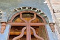
 Ornaments and details in a traditional house in Erbil Citadel.
 -
 Ornaments and details in a traditional house in Erbil Citadel.
 -
 A balcony in a traditional house in Erbil Citadel with ornamented hand-railing.
 -
 Erbil Citadel wall
 -
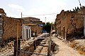
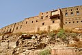
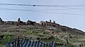 Dilapidated old houses around the Citadel
 -
 Old houses around the Citadel
 -
 Dilapidated old houses around the Citadel
 -
 Old houses around the Citadel
 -
 Old houses around the Citadel
 -
 One of the houses around Erbil Citadel


References
[edit]- ^abcd"Erbil Citadel – UNESCO World Heritage Centre".whc.unesco.org.Retrieved30 August2010.
- ^Nováček et al. 2008,p. 276
- ^Martha A. Morrison, David I. Owen, eds,General Studies and Excavations at Nuzi 9/1; Volume 2 In Honor of Ernest R. Lacheman.Eisenbrauns, 1981ISBN0931464080
- ^TimelineArchived14 August 2014 at theWayback MachineErbilCitadel.orq
- ^abVillard 2001
- ^Eidem 1985,p. 83
- ^Nováček et al. 2008,p. 260
- ^abcSourdel 2010
- ^Morony 1984,p. 359
- ^Morony 1984,p. 132
- ^Cahen 2010
- ^Woods 1977,pp. 49–50
- ^Nováček et al. 2008,p. 261
- ^Grousset, p. 379
- ^Grousset, p. 383
- ^ab"History".erbilcitadel.org. Archived fromthe originalon 19 April 2011.Retrieved30 August2010.
- ^"Historical Evolution".erbilcitadel.org. Archived fromthe originalon 6 April 2009.Retrieved30 August2010.
- ^Qassim Khidhir Hamad."The pride of erbil needs urgent care".niqash.org. Archived fromthe originalon 8 May 2010.Retrieved30 August2010.
- ^Ivan Watson."Kurds Displaced in Effort to Preserve Ancient City".NPR.Retrieved19 October2011.
- ^Fryer, Jonathan (2010).Kurdistan.London: Stacey international. p. 16.
- ^abcNováček et al. 2008,p. 262
- ^ab"Mahallas".erbilcitadel.org. Archived fromthe originalon 4 April 2009.Retrieved30 August2010.
- ^"The Mosque".erbilcitadel.org. Archived fromthe originalon 3 April 2009.Retrieved30 August2010.
- ^"The Hammam".erbilcitadel.org. Archived fromthe originalon 5 July 2009.Retrieved30 August2010.
- ^"Alleyways".erbilcitadel.org. Archived fromthe originalon 3 April 2009.Retrieved30 August2010.
- ^"Perimeter Wall".erbilcitadel.org. Archived fromthe originalon 4 April 2009.Retrieved30 August2010.
- ^ab"Houses".erbilcitadel.org. Archived fromthe originalon 9 March 2012.Retrieved30 August2010.
- ^"ARCHITECTURAL HERITAGE 01".erbilcitadel.org. Archived fromthe originalon 5 July 2009.Retrieved30 August2010.
- ^"Urban Growth".erbilcitadel.org. Archived fromthe originalon 9 March 2012.Retrieved30 August2010.
- ^Nováček et al. 2008
- ^"Erbil Citadel and Its Lost Wall".Academia.edu.Retrieved25 December2022.
- ^Kehrer 2009
- ^Kehrer 2010
- ^"The Citadel & The City".erbilcitadel.org. Archived fromthe originalon 2 April 2009.Retrieved30 August2010.
- ^"NASA: Kurdistan's Erbil Citadel oldest human-occupied settlement on Earth".Kurdistan24.
- ^"History on a Hill".earthobservatory.nasa.gov.1 April 2019.
- ^Centre, UNESCO World Heritage."Erbil Citadel".whc.unesco.org.
- ^McDermid 2010
- ^"Kurdistan's Erbil Citadel at risk of being removed from UNESCO World Heritage list".Ekurd.net.Retrieved18 February2017.
- Sources
- Cahen, Cl. (2010), "Begteginids", in Bearman, P.; Bianquis, Th.;Bosworth, C.E.;van Donzel, E.; Heinrichs, W.P. (eds.),Encyclopaedia of Islam(second ed.), Brill Online,OCLC624382576
- Eidem, Jesper (1985), "News from the eastern front: the evidence from Tell Shemshāra",Iraq,47:83–107,doi:10.2307/4200234,ISSN0021-0889,JSTOR4200234
- Kehrer, Nicole (2009),"Deutsche Experten untersuchen assyrische Grabstätte in Arbil",Deutsches Archäologisches Institut(in German), archived fromthe originalon 7 June 2011,retrieved8 July2010
- Kehrer, Nicole (2010),"Deutsche Archäologen arbeiten wieder im Irak",Deutsches Archäologisches Institut(in German), archived fromthe originalon 7 June 2011,retrieved8 July2010
- McDermid, Charles (29 July 2010),"A Facelift for an Ancient Kurdish Citadel",Time,archived fromthe originalon 31 July 2010,retrieved2 August2010
- Morony, Michael G. (1984),Iraq after the Muslim conquest,Princeton: Princeton University Press,ISBN978-0-691-05395-0
- Naval Intelligence Division (1944),Iraq and the Persian Gulf,Geographical Handbook Series,OCLC1077604
- Nováček, Karel; Chabr, Tomáš; Filipský, David; Janiček, Libor; Pavelka, Karel; Šída, Petr; Trefný, Martin; Vařeka, Pavel (2008),"Research of the Arbil Citadel, Iraqi Kurdistan, First Season",Památky Archeologické,99:259–302,ISSN0031-0506,retrieved13 July2010
- Sourdel, D. (2010), "Irbil", in Bearman, P.; Bianquis, Th.;Bosworth, C.E.;van Donzel, E.; Heinrichs, W.P. (eds.),Encyclopaedia of Islam(second ed.), Brill Online,OCLC624382576
- Villard, Pierre(2001), "Arbèles", in Joannès, Francis (ed.),Dictionnaire de la civilisation mésopotamienne,Bouquins (in French), Paris: Robert Laffont, pp. 68–69,ISBN978-2-221-09207-1
- Woods, John E. (1977), "A note on the Mongol capture of Isfahān",Journal of Near Eastern Studies,36(1): 49–51,doi:10.1086/372531,ISSN0022-2968,JSTOR544126
- Grousset, Rene,The Empire of the Steppes,(Translated from the French by Naomi Walford), New Brunswick:Rutgers University Press(1970)
Further reading
[edit]- Nordland, Rod (10 October 2017)."After 6,000 Years of Human Habitation, One Family and Lots of Mice".The New York Times.ISSN0362-4331.
External links
[edit]- Citadel of Arbil on the World Heritage List
- High Commission for Erbil Citadel Revitalization (HCECR)
- Citadel Documentation Project[permanent dead link]
- Research of the citadel at Arbil, Kurdistan Region
- http:// academia.edu/119028755/Pictures_of_houses_in_the_vicinity_of_Erbil_Citadel
 | ||
| ||