
Corinth
This articleneeds additional citations forverification.(May 2010) |
Corinth
Κόρινθος | |
|---|---|
Clockwise from top left:Corinth Courthouse, the walled gates ofAcrocorinth,Isthmus of Corinth,Statue of Pegasus, Ethnikis Antistaseos,Temple of Apollo | |
 Seal | |
 Corinth Location within the regional unit  | |
| Coordinates:37°56′19″N22°55′38″E/ 37.93861°N 22.92722°E | |
| Country | Greece |
| Administrative region | Peloponnese |
| Regional unit | Corinthia |
| Municipality | Corinth |
| Area | |
| • Municipal unit | 102.19 km2(39.46 sq mi) |
| Highest elevation | 10 m (30 ft) |
| Lowest elevation | 0 m (0 ft) |
| Population (2021)[1] | |
| • Municipal unit | 38,485 |
| • Municipal unit density | 380/km2(980/sq mi) |
| • Community | 30,816 |
| Demonym | Corinthian |
| Time zone | UTC+2(EET) |
| • Summer (DST) | UTC+3(EEST) |
| Postal code | 20100 |
| Area code(s) | (+30) 27410 |
| Vehicle registration | KP |
| Website | www |


Corinth(/ˈkɒrɪnθ/KORR-inth;Greek:Κόρινθος,romanized:Kórinthos,Modern Greekpronunciation:[ˈkorinθos]) is a municipality inCorinthiainGreece.The successor to theancient city of Corinth,it is a formermunicipalityinCorinthia,Peloponnese,which is located in south-centralGreece.Since the 2011 local government reform, it has been part of themunicipality of Corinth,of which it is the seat and a municipal unit.[2]It is the capital of Corinthia.
It was founded asNea Korinthos(Νέα Κόρινθος), orNew Corinth,in 1858 after an earthquake destroyed the existing settlement of Corinth, which had developed in and around the site of the ancient city.
History
[edit]Corinth derives its name fromAncient Corinth,acity-stateof antiquity. The site was occupied from before 3000 BC.
Ancient Greece
[edit]Historical references begin with the early 8th century BC, whenancient Corinthbegan to develop as a commercial center. Between the 8th and 7th centuries, the Bacchiad family ruled Corinth.Cypselusoverthrew theBacchiadfamily, and between 657 and 550 BC, he and his sonPerianderruled Corinth as the Tyrants.
In about 550 BC, an oligarchical government seized power. This government allied withSpartawithin thePeloponnesian League,and Corinth participated in thePersian WarsandPeloponnesian Waras an ally of Sparta. After Sparta's victory in the Peloponnesian war, the two allies fell out with one another, and Corinth pursued an independent policy in the various wars of the early 4th century BC. After theMacedonianunification of Greece, theAcrocorinthwas the seat of a Macedonian garrison until 243 BC, when the city joined theAchaean League.
Ancient Rome
[edit]Nearly a century later, in 146 BC, Corinth was captured and was completely destroyed by the Roman army.

As a newly rebuilt Roman colony in 44 BC, Corinth flourished and became the administrative capital of the Roman province ofAchaea.[3]
Medieval times
[edit]An important earthquake touched Corinth and its region in 856, causing around 45000 deaths.[4]
Modern era
[edit]In 1858, the old city, now known as Ancient Corinth (Αρχαία Κόρινθος,Archaia Korinthos), located three kilometres (two miles) southwest of the modern city, was totally destroyed by a magnitude 6.5 earthquake. New Corinth (Nea Korinthos) was then built to the north-east of it, on the coast of the Gulf of Corinth. In 1928, a magnitude 6.3 earthquake devastated the new city, which was then rebuilt on the same site.[5]In 1933, there was a great fire, and the new city was rebuilt again.
During the German occupation inWorld War II,the Germans operated a Dulag transit camp for British, Australian, New Zealander and Serbian prisoners of war and aforced labourcamp in the town.[6][7]
Geography
[edit]Located about 78 kilometres (48 mi) west ofAthens,Corinth is surrounded by the coastal townlets of (clockwise)Lechaio,Isthmia,Kechries,and the inland townlets ofExamiliaand the archaeological site and village of ancient Corinth. Natural features around the city include the narrow coastal plain ofVocha,theCorinthian Gulf,theIsthmus of Corinthcut by itscanal,theSaronic Gulf,theOneia Mountains,and the monolithic rock ofAcrocorinth,where the medievalacropoliswas built.
Climate
[edit]According to the nearby weather station of Velo, operated by theHellenic National Meteorological Service,Corinth has a hot-summerMediterranean climate(Köppen climate classification:Csa), with hot, dry summers and cool, rainy winters. The hottest month is July with an average temperature of 28.7 °C (83.7 °F) while the coldest month is January with an average temperature of 9.1 °C (48.4 °F). Corinth receives about 463 mm of rainfall per year and has an average annual temperature of 18.1 °C (64.6 °F).
| Climate data for Velo, Corinth (1988–2010) | |||||||||||||
|---|---|---|---|---|---|---|---|---|---|---|---|---|---|
| Month | Jan | Feb | Mar | Apr | May | Jun | Jul | Aug | Sep | Oct | Nov | Dec | Year |
| Mean daily maximum °C (°F) | 13.4 (56.1) |
13.9 (57.0) |
16.5 (61.7) |
20.3 (68.5) |
25.7 (78.3) |
30.7 (87.3) |
33.2 (91.8) |
32.9 (91.2) |
28.4 (83.1) |
23.6 (74.5) |
18.5 (65.3) |
14.4 (57.9) |
22.6 (72.7) |
| Daily mean °C (°F) | 9.1 (48.4) |
9.4 (48.9) |
11.9 (53.4) |
15.7 (60.3) |
21.1 (70.0) |
26.1 (79.0) |
28.7 (83.7) |
28.1 (82.6) |
23.4 (74.1) |
18.8 (65.8) |
13.8 (56.8) |
10.5 (50.9) |
18.1 (64.5) |
| Mean daily minimum °C (°F) | 5.3 (41.5) |
5.0 (41.0) |
6.5 (43.7) |
9.0 (48.2) |
12.9 (55.2) |
16.8 (62.2) |
19.5 (67.1) |
19.8 (67.6) |
16.9 (62.4) |
13.8 (56.8) |
9.9 (49.8) |
6.9 (44.4) |
11.9 (53.3) |
| Averageprecipitationmm (inches) | 72.0 (2.83) |
50.9 (2.00) |
53.7 (2.11) |
28.7 (1.13) |
22.3 (0.88) |
6.4 (0.25) |
5.0 (0.20) |
11.9 (0.47) |
19.4 (0.76) |
40.8 (1.61) |
73.5 (2.89) |
78.6 (3.09) |
463.2 (18.22) |
| Source:HNMS[8] | |||||||||||||
Demographics
[edit]| Year | Pop. | ±% |
|---|---|---|
| 2001[9] | 36,991 | — |
| 2011[10] | 38,132 | +3.1% |
| 2021[1] | 38,485 | +0.9% |
The Municipality of Corinth (Δήμος Κορινθίων) had a population of 55,941 according to the 2021 census, the second most populous municipality in thePeloponnese RegionafterKalamata.[1]The municipal unit of Corinth had 38,485 inhabitants, of which Corinth itself had 30,816 inhabitants, placing it in second place behind Kalamata among the cities of the Peloponnese Region.[1]

The municipal unit of Corinth (Δημοτική ενότητα Κορινθίων) includes apart from Corinth proper the town ofArchaia Korinthos,the town ofExamilia,and the smaller settlements ofXylokerizaandSolomos.[1]The municipal unit has an area of 102.187 km2.[9]
Economy
[edit]Industry
[edit]Corinth is a major industrial hub at a national level. TheCorinth Refineryis one of the largestoil refiningindustrial complexes inEurope.Ceramic tiles, copper cables, gums, gypsum, leather, marble, meat products, medical equipment, mineral water and beverages, petroleum products, and salt are produced nearby. As of 2005[update],a period of Economic changes commenced as a large pipework complex, a textile factory and a meat packing facility diminished their operations.

Transport
[edit]
Roads
[edit]Corinth is a major road hub. TheA7tollmotorway forTripoliandKalamata,(and Sparta via theA71toll), branches off theA8/E94tollmotorway from Athens at Corinth. Corinth is the main entry point to the Peloponnesian peninsula, the southernmost area of continental Greece.
Bus
[edit]KTELKorinthias[11]provides intercity bus service in the peninsula and to Athens via the Isthmos station southeast of the city center.[12]Local bus service is also available.
Railways
[edit]The metre gauge railway from Athens and Pireaeus reached Corinth in 1884. This station closed to regular public transport in 2007. In 2005, two years prior, the city was connected to theAthens Suburban Railway,following the completion of the newCorinth railway station.The journey time from Athens to Corinth is about 55 minutes. The train station is 5 minutes by car from the city centre and parking is available for free.
Port
[edit]The port of Corinth, located north of the city centre and close to the northwest entrance of theCorinth Canal,at 37 56.0’ N / 22 56.0’ E, serves the local needs of industry and agriculture. It is mainly a cargo exporting facility.
It is an artificial harbour (depth approximately 9 m (30 ft), protected by a concretemole(length approximately 930 metres, width 100 metres, mole surface 93,000 m2). A new pier finished in the late 1980s doubled the capacity of the port. The reinforced mole protects anchored vessels from strong northern winds.
Within the port operates acustomsoffice facility and aHellenic Coast Guardpost. Sea traffic is limited to trade in the export of local produce, mainly citrus fruits, grapes, marble, aggregates and some domestic imports. The port operates as a contingency facility for general cargo ships,bulk carriersandROROs,in case ofstrikesatPiraeusport.
Ferries
[edit]There was formerly aferrylink toCatania,SicilyandGenoainItaly.
Canal
[edit]
The Corinth Canal, carrying ship traffic between the westernMediterranean Seaand theAegean Sea,is about 4 km (2.5 mi) east of the city, cutting through theIsthmus of Corinththat connects the Peloponnesian peninsula to the Greek mainland, thus effectively making the former an island. The builders dug the canal through the Isthmus at sea level; no locks are employed. It is 6.4 km (4.0 mi) in length and only 21.3 metres (70 ft) wide at its base, making it impassable for most modern ships. It now has little economic importance.
The canal was mooted in classical times and an abortive effort was made to build it in the 1st century AD.Julius CaesarandCaligulaboth considered digging the canal but died before starting the construction.[13]The emperorNerowas the first to attempt to construct the canal. The Roman workforce responsible for the initial digging consisted of 6,000 Jewishprisoners of war.Modern construction started in 1882, after Greece gained independence from theOttoman Empire,but was hampered by geological and financial problems that bankrupted the original builders. It was completed in 1893, but due to the canal's narrowness, navigational problems and periodic closures to repair landslips from its steep walls, it failed to attract the level of traffic anticipated by its operators. It is now used mainly for tourist traffic.
Sport
[edit]The city'sassociation footballteam isKorinthos F.C.(Π.Α.E. Κόρινθος), established in 1999 after the merger of Pankorinthian Football Club (Παγκορινθιακός) and Corinth Football Club (Κόρινθος). During the 2006–2007 season, the team played in the Greek Fourth Division's Regional Group 7. The team went undefeated that season and it earned the top spot.[14]This granted the team a promotion to theGamma Ethnikí (Third Division)for the 2007–2008 season. For the 2008–2009 season, Korinthos F.C. competed in the Gamma Ethniki (Third Division) southern grouping.
Twin towns/sister cities
[edit]Corinth istwinnedwith:
Notable people
[edit]- Anastasios Bakasetas(1993–), Greek footballer
- Evangelos Ikonomou(1987–), Greek footballer
- George Kollias(1977–), drummer for US technical death metal bandNile.
- Georgios Leonardopoulos,army officer
- Macarius(1731–1805), Metropolitan bishop of Corinth
- Ioannis Papadiamantopoulos(1766–1826), revolutionary leader during theGreek War of Independence.
- Irene Papas(1929–2022), Greek actress
- Costas Soukoulis(1951–2024), Professor of Physics atIowa State University
- Konstantinos Triantafyllopoulos(1993–) Greek footballer
- Panagis Tsaldaris(1868–1936), Greek politician and prime minister of Greece
- Panagiotis Tzanavaras(1964–), Greek footballer and football manager
- Nikolaos Zafeiriou(1871–1947), Greek artillery officer
Other locations named after Corinth
[edit]Due to its ancient history and the presence ofSt. Paul the Apostlein Corinth some locations all over the world have been named Corinth.
Gallery
[edit]-
 Pegasus Square in New Corinth
 -
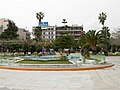 View of the Central Square of the city
 -
 Aerial photograph of theIsthmus of Corinth


See also
[edit]References
[edit]- ^abcde"Αποτελέσματα Απογραφής Πληθυσμού - Κατοικιών 2021, Μόνιμος Πληθυσμός κατά οικισμό"[Results of the 2021 Population - Housing Census, Permanent population by settlement] (in Greek). Hellenic Statistical Authority. 29 March 2024.
- ^"ΦΕΚ B 1292/2010, Kallikratis reform municipalities"(in Greek).Government Gazette.
- ^"Corinth | Greece | Britannica".8 June 2023.
- ^IISEENET (Information Network of Earthquake disaster Prevention Technologies) - Search Page
- ^Tsapanos, Theodoros M.; et al. (March 2011)."Deterministic seismic hazard analysis for the city of Corinth, central Greece"(PDF).Journal of the Balkan Geophysical Society.14(1): 1–14.Archived(PDF)from the original on 4 September 2011.Retrieved21 July2015.
- ^Megargee, Geoffrey P.; Overmans, Rüdiger; Vogt, Wolfgang (2022).The United States Holocaust Memorial Museum Encyclopedia of Camps and Ghettos 1933–1945. Volume IV.Indiana University Press,United States Holocaust Memorial Museum.p. 523.ISBN978-0-253-06089-1.
- ^"Barackenlager Korinth".Bundesarchiv.de(in German).Retrieved26 February2023.
- ^"Κλιματικά Δεδομένα ανά Πόλη- ΜΕΤΕΩΓΡΑΜΜΑΤΑ, ΕΜΥ, Εθνική Μετεωρολογική Υπηρεσία".
- ^ab"Population & housing census 2001 (incl. area and average elevation)"(PDF)(in Greek). National Statistical Service of Greece.Archived(PDF)from the original on 21 September 2015.
- ^"Απογραφή Πληθυσμού - Κατοικιών 2011. ΜΟΝΙΜΟΣ Πληθυσμός"(in Greek). Hellenic Statistical Authority.
- ^"Έναρξη παροχής της ηλεκτρονικής υπηρεσίας E-Services – Παρασκευή, 20 Φεβρουαρίου 2009".ktelkorinthias.gr(in Greek). 18 September 2013.Retrieved10 November2023.
- ^"Corinth – Map and travel Information".Archived fromthe originalon 27 April 2016.Retrieved26 April2016.
- ^"A Brief History of the Corinth Canal".9 December 2016.
- ^[1]Archived23 July 2010 at theWayback Machine
- ^"Gemellaggio tra Siracusa e Corinto".Liberta Sicilia. 8 January 2008. Archived fromthe originalon 9 June 2008.Retrieved19 March2008.
External links
[edit] Corinthtravel guide from Wikivoyage
 Media related toCorinthat Wikimedia Commons
- City of Corinth official website(in Greek)
- Kórinthos FC official website(in Greek)
Places adjacent to Corinth | ||||||||||||||||
|---|---|---|---|---|---|---|---|---|---|---|---|---|---|---|---|---|
| ||||||||||||||||
| International | |
|---|---|
| National | |
| Other | |