Wimbleball Lake
| Wimbleball Reservoir | |
|---|---|
 The Dam | |
| Location | Somerset |
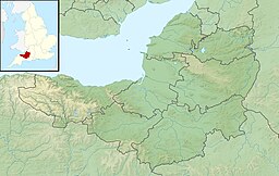
| Coordinates | 51°04′N3°28′W/ 51.067°N 3.467°W |
| Type | reservoir |
| Primary inflows | River Haddeo |
| Primary outflows | River Haddeo |
| Basincountries | United Kingdom |
| Surface area | 374 acres (1.51 km2) |
| Average depth | 50 metres (160 ft) |
| Water volume | 21,000 megalitres (17,000 acre⋅ft) |

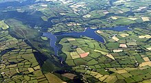
Wimbleball LakeonExmoorinSomerset,England, is a water supplyreservoirconstructed in the 1970s and completed in 1979.
The 161 feet (49 m) highdamis ofconcrete buttressconstruction and impounds theRiver Haddeoto provide a water storage capacity of some 21,000 megalitres over an area of 374 acres (1.51 km2). Aggregate for the dam came from a quarry atBamptonand sand fromUffculme.These were combined to give a pinkish tinge to blend in with the local geology.
The tributary valleys include the River Pulham, which passes the village ofBrompton Regisand continues to Hartford where it joins the Haddeo.[1]
At times of low flow in theRiver Exe,water is released into the river forabstractiondownstream atTivertonandExeter.The effects of this regulation of the water flow from the lake have been studied by comparing the regulated River Haddeo and the neighbouring (unregulated) River Pulham. It showed that the main thermal effects of impoundment and regulation have been to raise mean water temperature, eliminate freezing conditions, depress summer maximum values, delay the annual cycle and reduce diurnal fluctuation.[2]
In 2001 - 2002South West Watercommissioned a detailed assessment of fish population, physical habitat, flow and water quality data within the River Haddeo, since it has been subject to regulated releases from Wimbleball Reservoir, to identify potential bottlenecks restricting the development of juvenilesalmonpopulations.[3]

Managed by the charity South West Lakes Trust, the lake offers a popular location forwalking,camping,birdwatching,angling,sailing,windsurfing,canoeing,rowingandkayaking.In December 2005 the trust was successful in obtaining funding for a £1 million project to provide a new rowing store, conversion of barn space into showers and changing areas, new sports equipment, an accessible bird hide, and interpretation, improved access, and signage around the site.[4]In 2006 a new £1 million activity centre opened.[5]
Wimbleball Sailing Club provides training, cruising and racing for its members, it is a non profit family sailing club operating every Sunday throughout the year and Wednesday, Friday and Saturday during the summer. The club is also home to a Sailability group providing sailing for the disabled.
The southern end of the lake is overlooked by the tower ofOld Church of St James, Upton.
References
[edit]- ^"Incised Wooded Valleys"(PDF).Exmoor National Park.Retrieved24 November2007.
- ^Webb, BW; Walling, DE (1996). "Long-term variability in the thermal impact of river impoundment and regulation".Applied Geography.16(3): 211–223.doi:10.1016/0143-6228(96)00007-0.
- ^"Habitat and Flow Improvements to benefit Atlantic Salmon in the River Haddeo".APEM Aquatic Scientists.Retrieved24 November2007.
- ^"Funding for Wimbleball Activities Centre".West Somerset Online.Retrieved24 November2007.
- ^"Wimbleball Lake".Somerset Rural Renaissance.Retrieved14 May2010.


