1762 Arakan earthquake
| Local date | 2 April 1762 |
|---|---|
| Local time | 17:00 |
| Magnitude | 8.5–8.8Mw |
| Epicentre | 22°00′N92°00′E/ 22.0°N 92.0°E |
| Areas affected | Bangladesh |
| Max.intensity | MMI XI (Extreme) |
| Tsunami | Yes |
| Casualties | 200+ |
The1762 Arakan earthquakeoccurred at about 17:00 local time on 2 April, with anepicentresomewhere along the coast fromChittagong(modernBangladesh) toArakanin modernMyanmar.[1]It had an estimatedmoment magnitudebetween 8.5 and 8.8 and a maximum estimatedintensityof XI (Extreme). It triggered a localtsunamiin theBay of Bengaland caused at least 200 deaths. The earthquake was associated with major areas of both uplift and subsidence. It is also associated with a change in course of theBrahmaputra Riverto from east ofDhaka(Old Brahmaputra River) to 150 kilometres (93 mi) to the west via theJamuna River.[2]
Tectonic setting[edit]

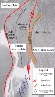
The eastern part of Bangladesh and the southwestern part of Burma lie along the highly obliqueconvergent boundarybetween theIndian Plateand theEurasian Plate.The degree to which this deformation is partitioned into zones ofthrust tectonics(accommodating that part of the motion perpendicular to the boundary) andstrike-slip tectonics(accommodating the northward movement of the Indian Plate) varies along the boundary. A pure strike-slip boundary that strike parallel to the plate vector runs along the Western Burma Scarp, that is replaced to the north by the Indo-Burmese Wedgefold and thrust belt,at the western edge of the boundary zone, and a series of major dextral (right lateral)strike-slip faults,particularly theKabaw Faultand Sagaing Fault further to the east.[3]The presence of activesubductionalong the eastern margin of the Bay of Bengal is disputed.[3][4]
Earthquake[edit]
The earthquake lasted for about four minutes at Chittagong. The epicentre is not well-constrained and likely locations have varied from near Chittagong to along the Arakan coast. The extent of the rupture is uncertain but may have been as much as 700 km (430 mi) along the plate interface. This is based both on the extent of uplift, which was recorded along the coast of Burma from Foul Island toRamree Island,and the area of subsidence aroundChittagong,further north. The 700 km (430 mi) extent combined with an estimated displacement of ten metres gives a maximum estimated magnitude of 8.8 on the moment magnitude scale.[5]More recent research suggested a shorter rupture measuring 500 km (310 mi), which combined with estimated displacement of 9 to 16 meters gives an estimated magnitude of 8.5 on the moment magnitude scale.[6]Other workers have pointed out that neither the subsidence, which could be due to lateral spreading, nor the uplift, which is not unequivocally linked to the 1762 earthquake, necessarily provide a reasonable estimate for the size of this event and prefer to regard this as a magnitude 7–8 earthquake.[4]
Studies of upliftedmarine terracesalong the Burmese coast have found evidence for three uplifts, the most recent of which is interpreted to be from the 1762 earthquake. TheSt. Martin's Islandhas been uplifted by 2–2.5 m (6 ft 7 in – 8 ft 2 in) during that earthquake.[1]A repeat period of about 500 to 700 years was suggested for earthquakes similar to that in 1762.[1]
Tsunami[edit]
A tsunami was reported along the northeastern coast of the Bay of Bengal and atDhakaandKolkata.[7]This is regarded as a local tsunami, as no effects were recorded on the western side of the bay.[4]
Damage[edit]
In Chittagong, it was reported that no buildings or walls built of brick had escaped either destruction or serious damage. The East India Company's factory inside the fort was so badly damaged that it could no longer be safely used.[8]An area of about 60 square miles (160 km2) permanently subsided beneath the sea along the coast near Chittagong. At Bar Chara, just north ofCox's Bazar,the land sank and 200 people were killed. Chittagong was said to have "suffered severely" withsoil liquefactioneffects such assand volcanoesand ground fissures.[9]
See also[edit]
References[edit]
- ^abcMondal, Dhiman R.; McHugh, Cecilia M.; Mortlock, Richard A.; Steckler, Michael S.; Mustaque, Sharif; Akhter, Syed Humayun (October 2018)."Microatolls document the 1762 and prior earthquakes along the southeast coast of Bangladesh".Tectonophysics.745:196–213.Bibcode:2018Tectp.745..196M.doi:10.1016/j.tecto.2018.07.020.S2CID53578945.
- ^"Flooding concerns return to northeastern India".Al Jazeera.
- ^abMaurin, T.; Rangin C. (2009). "Impact of the 90°E ridge at the Indo-Burmese subduction zone imaged from deep seismic reflection data".Marine Geology.266(1–4): 143–155.Bibcode:2009MGeol.266..143M.doi:10.1016/j.margeo.2009.07.015.
- ^abcKundu, B.; Gahalaut V.K. (2012). "Earthquake occurrence processes in the Indo-Burmese wedge and Sagaing fault region".Tectonophysics.524–525: 135–146.Bibcode:2012Tectp.524..135K.doi:10.1016/j.tecto.2011.12.031.
- ^Cummins, P.R. (2007). "The potential for giant tsunamigenic earthquakes in the northern Bay of Bengal".Nature.449(7158): 75–78.Bibcode:2007Natur.449...75C.doi:10.1038/nature06088.PMID17805292.S2CID4425148.
- ^Wang, Yu (2013).Earthquake Geology of Myanmar(Ph.D.).California Institute of Technology.doi:10.7907/XWW2-9P26.
- ^National Geophysical Data Center / World Data Service: NCEI/WDS Global Historical Tsunami Database. NOAA National Centers for Environmental Information."Tsunami Event Information".NOAA National Centers for Environmental Information.doi:10.7289/V5PN93H7.Retrieved15 April2022.
- ^Verelst (1764)."An Account of the Earthquakes that have been felt in the Province of Islamabad, with the Damages attending them, from the 2d to the 19th of April, 1762".Philosophical Transactions of the Royal Society.53:265–269.doi:10.1098/rstl.1763.0043.Retrieved27 March2012.
- ^National Geophysical Data Center / World Data Service (NGDC/WDS): NCEI/WDS Global Significant Earthquake Database. NOAA National Centers for Environmental Information (1972)."Significant Earthquake Information".NOAA National Centers for Environmental Information.doi:10.7289/V5TD9V7K.Retrieved15 April2022.
Further reading[edit]
- Gupta, H.;Gahalaut, V. (2009). "Is the Northern Bay of Bengal Tsunamigenic?".Bulletin of the Seismological Society of America.99(6): 3496–3501.Bibcode:2009BuSSA..99.3496G.doi:10.1785/0120080379.ISSN0037-1106.

