
Abingdon Road

Abingdon Roadis the main arterial road to the south of the city ofOxford,England.[1][2]The road passes through the suburbs ofGrandpontandNew Hinksey.It is named after the town ofAbingdonto the south.
History
[edit]Part of the road was known as theCauseyorCausyuntil the 17th century, after the Grandpont causeway that ran fromSt Aldate'stoHinksey Hill.[3]
Location
[edit]
To the north, the road crosses theRiver ThamesatFolly Bridgeand becomesSt Aldate's,which leads to the centre of Oxford atCarfax,although the one-way system now prevents traffic from taking a direct route. The road is designated theA4144and joins with theA423dual carriagewaythat forms part of theOxford Ring Roadto the south.
At its southern end, the road turns sharply to the west and is known as Old Abingdon Road, crossing theCherwell Valleyrailway line over a brick bridge to the south of which is the site of the formerAbingdon Road Halt railway station.The bridge is known locally as the Red Bridge, and it has given its name to the area, in particular toRedbridge Park and Ride,andRedbridgeWaste Recycling Facility.

The Duke of Monmouthpublic houseis located on Abingdon Road.[4]
Abingdon Road forms part of theA4144 road.It was previously part of theA34before the Oxford Ring Road was built.
See also
[edit]- Abingdon Arms,a historic Oxford inn
Gallery
[edit]-
![The castellated Isis House (1849) on Abingdon Road, just south of Folly Bridge[1]](https://upload.wikimedia.org/wikipedia/commons/thumb/a/a8/House_on_Abingdon_Road_-_geograph.org.uk_-_792591.jpg/98px-House_on_Abingdon_Road_-_geograph.org.uk_-_792591.jpg) The castellatedIsis House(1849) on Abingdon Road, just south ofFolly Bridge[1]
The castellatedIsis House(1849) on Abingdon Road, just south ofFolly Bridge[1] -
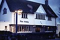 The Follypublic houseon Abingdon Road
 -
 The formerpost officeon Abingdon Road
 -
 Terracotta relief ofQueen Victoriaat the former post office
 -
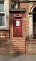 Edward VIIwall-mounted postbox at the former post office
 -
 The White House pub on Abingdon Road
 -
 Tesco Expressstore on the site of the former Fox and Hounds pub on Abingdon Road
![The castellated Isis House (1849) on Abingdon Road, just south of Folly Bridge[1]](/translate/en.wikipedia.org?u=https%3A%2F%2Fen.wikipedia.org%2Fwiki%2FFile%3AHouse_on_Abingdon_Road_-_geograph.org.uk_-_792591.jpg&t=vi)


References
[edit]- ^abSherwood, Jennifer;Pevsner, Nikolaus(1974).The Buildings of England:Oxfordshire.Penguin Books.pp. 327, 335–336.ISBN0-14-071045-0.
- ^Locale Abingdon Road,The Oxford Guide.
- ^Hibbert, Christopher,ed. (1988). "Abingdon Road".The Encyclopaedia of Oxford.Macmillan.pp. 1–2.ISBN0-333-39917-X.
- ^Morris, Jan(1987).Oxford(3rd ed.).Oxford University Press.p.123.ISBN0-19-282065-6.
External links
[edit]- Oxford from the Abingdon Road— an old print
51°44′19″N1°15′10″W/ 51.7385°N 1.2527°W
ThisOxfordshirelocation article is astub.You can help Wikipedia byexpanding it. |
This England road or road transport-related article is astub.You can help Wikipedia byexpanding it. |