Alland
Alland | |
|---|---|
 | |
| Coordinates:48°4′N16°5′E/ 48.067°N 16.083°E | |
| Country | Austria |
| State | Lower Austria |
| District | Baden |
| Government | |
| •Mayor | Johann Grundner |
| Area | |
| • Total | 68.71 km2(26.53 sq mi) |
| Elevation | 331 m (1,086 ft) |
| Population (2018-01-01)[2] | |
| • Total | 2,622 |
| • Density | 38/km2(99/sq mi) |
| Time zone | UTC+1(CET) |
| • Summer (DST) | UTC+2(CEST) |
| Postal code | 2534 |
| Area code | 02258 |
| Website | alland.at |
Allandis amarket townin the district ofBadenin theAustrianstate ofLower Austria.
Geography
[edit]It is located in theIndustrieviertelregion of Lower Austria, about 20 km (12 mi) southwest of the Austrian capitalVienna.Alland is situated in a valley of theVienna Woods(Wienerwald) mountain range and recreation area. The municipal area comprises the village ofMayerlingwith its hunting lodge, today aCarmelitemonastery.
The present-day municipality was formed in 1972 by the merger of Alland and Raisenmarkt comprising thecadastral communitiesof Alland, Glashütten, Groisbach, Innerer Kaltenbergerforst and Äußerer Kaltenbergerforst, Mayerling, Pöllerhof, Raisenmarkt, Rohrbach, Schwechatbach, Weissenweg, and Windhaag. It is the largest municipality in Baden District by area.
History
[edit]Archaeological excavations ofLinear Potteryartifacts indicate that the valley had been settled since theNeolithicera. A first church in Alland was erected in the 8th century.

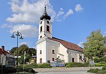
In 1002 KingHenry II of Germanyenfeoffed large estates around Alland (derived fromAdel,aristocratic land) up to theTriestingRiver to theBabenbergmargraveHenry I of Austria.The Sts George and Margareta parish church was first mentioned in 1123. In 1133 MargraveLeopold IIIfounded nearbyHeiligenkreuz Abbey.
Alland remained a possession of the Babenberg rulers after their march was elevated to theDuchy of Austriaand the place where the last male heirFrederick I of Austria,son ofGertrude of Babenberg,was born in 1249. Frederick however was not able to assert his claims; he and his friendConradin of Hohenstaufenwere beheaded by order of KingCharles I of Naplesin 1268. The Babenberg hereditary lands were taken over by KingOttokar II of Bohemiaand seized by theHabsburgkingRudolf I of Germanyin 1276. The parish was incorporated into Heiligenkreuz Abbey at the behest ofPope Urban VIin 1386.
Held by the Lords ofKottingbrunnfrom 1507, the lands were devastated byOttomanforces during the 1529Siege of Viennaand again in the course of theBattle of Viennain 1683. The Mayerling hunting lodge, a Heiligenkreuz possession since 1550, was acquired by ArchdukeRudolf of Austria,the heir to theAustro-Hungariancrown, in 1886. Three years later it saw theMayerling Incidentoccur, when Rudolf and his beloved killed themselves here. Immediately afterwards Rudolf's father EmperorFranz Josephordered the conversion of the hunting lodge into a monastery which he committed to Carmelite nuns to pray for his son's salvation.
Since thefin de siècle,Alland has been converted to a tourist resort and a spa town that is a favorite of the nearby Vienna residents. After theAnschlussannexation of Austria byNazi Germany,the Mayerling monastery was dissolved, the nuns expelled, and the premises turned into aforced labourcamp in connection with the construction of the nearbyReichsautobahn.In the late days ofWorld War IIthe Alland area saw heavy fighting between theI SS Panzer Corpsunder the command of GeneralJosef DietrichandRed Armyforces of the6th Guards Tank Armyunder MarshalFyodor Tolbukhinfrom 4 to 22 April 1945.
After the war, the demolished Mayerling monastery was restored to the Carmelites and the destroyed buildings were reconstructed. In the 1950s and 60s Alland regained its status as a popular destination for daytrippers and commuters from and to Vienna. The municipality was elevated to a market town in 2002.
Politics
[edit]
Seats in the municipal assembly (Gemeinderat) as of 2010 elections:
- Austrian People's Party(ÖVP): 13
- Social Democratic Party of Austria(SPÖ): 6
- Freedom Party of Austria(FPÖ): 1
- ALL (Independent): 1
Notable people
[edit]- Frederick I, Margrave of Baden(1249-1268).
- Leopold von Schrötter(1837–1908), internist and laryngologist, opened the Alland lung clinic in 1898.
References
[edit]- ^"Dauersiedlungsraum der Gemeinden Politischen Bezirke und Bundesländer - Gebietsstand 1.1.2018".Statistics Austria.Retrieved10 March2019.
- ^"Einwohnerzahl 1.1.2018 nach Gemeinden mit Status, Gebietsstand 1.1.2018".Statistics Austria.Retrieved9 March2019.


