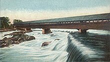
Amoskeag Falls
| Amoskeag Falls | |
|---|---|
 | |
 | |
| Location | Manchester, New Hampshire,United States |
| Coordinates | 43°00′08″N71°28′22″W/ 43.00222°N 71.47278°W |
TheAmoskeag Fallsare a set of waterfalls on theMerrimack RiverinManchester, New Hampshire,United States.
History
[edit]"Amoskeag" derives from thePennacookNative Americanword "Namoskeag", which roughly translates as "good fishing place". Here, the Merrimack River drops 50 feet (15 m) over the course of 0.25 miles (0.40 km).[1]Local tribes in the region fished Amoskeag Falls for its plentifulmigratingsturgeon,alewife,andsalmon,which were easily caught in therapids.Natives typically used a combination of large nets strung across the river. Significant native settlements were sited near the falls, particularly on the high bluffs overlooking the east side of the river.
In 1807,Samuel Blodgettstarted acanalandlocksystem at the river to help vessels navigate around the falls, opening the area to development. This soon led to the use of the falls for apower canalto providewater powerfor Manchester's 19th century industrial development, most notable for theAmoskeag Manufacturing Company.[2]
Use of the name
[edit]Due to the significance of the falls in Manchester history, a number of local companies have adopted their name. Examples include theAmoskeag Manufacturing Company(which operated a majority of Manchester'stextilemills using power from the falls until they closed in the midst of labor strikes in 1935), its division called theAmoskeag Locomotive Works(an early manufacturer offire trucksand train cars), and theAmoskeag Fishways(an environmental education center located at the Amoskeag Falls).
References
[edit]- ^U.S. Geological Survey7.5-minute topographic map series,Manchester Northquadrangle, 1982
- ^History of the Amoskeag FallsArchivedMay 24, 2005, at theWayback Machine
