
Avenida Figueroa Alcorta


Avenida Figueroa Alcortais a major thoroughfare inBuenos Aires,Argentina,with a length of over 7 km (4.3 mi) along the city's northside.
History[edit]
The rapid northward growth of the city of Buenos Aires during the late nineteenth century was facilitated by plans for a number of boulevards in the area by MayorTorcuato de Alvear.Shortly after the opening of Viceroy Vértiz Avenue (todayAvenida del Libertador) in 1906, a parallel boulevard was begun to serve the numerous upscale neighborhoods planned for the largely undeveloped northside.[1]
Planned with the assistance ofFrench ArgentineurbanistCarlos Thaysand around his recent remodeling ofParque Tres de Febrero,the thoroughfare was opened on the 1910 centennial of theMay Revolutionthat led to independence and was, accordingly, namedAvenida Centenario.Thays also designed a new residential neighborhood anchored around the new avenue:Barrio Parque,opened for development in 1912.[2]The Sanitation Works Commission's massivewater reclamationplant was subsequently built along the avenue's northern stretch.


Chrysler Motorsopened an assembly plant on the avenue in 1932 (since demolished), an investment complemented by a testing facility housed in an ornate structure north of Barrio Parque (the former facility today houses condominiums and an automobile museum).[3]The northern end of the avenue became home to theRiver PlateFootball Club's monumentalstadium,finished in 1938.[4]The avenue was later graced by tennis and country clubs, parks and a number of monumental public buildings, though its boulevard medians were removed around 1970 to accommodate growing traffic. Excavations along the avenue in 2008 uncovered remains of the formerHansen's Café,among the city's first and most populartangoredoubts until its demolition in 1912.[5]
Itinerary[edit]

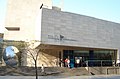
A one way thoroughfare, the avenue begins at its eastern end past the Buenos AiresPalais de Glacein the upscaleRecoletasection. Passing by theUniversity of Buenos AiresFaculty of Law,the monumentalNeoclassicstructure dating from the administration of PresidentJuan Perón(who had it built in the early 1950s as the future headquarters of theCGT,Argentina's largest labor union), the avenue also travels behind theNational Fine Arts Museumand past United Nations Plaza. There, architectEduardo Catalanoinstalled the iconicFloralis Genéricain 2001. Past UN Plaza, the avenue passes byArgentine Public TelevisionStudios, an extensiveModerniststructure opened in 1978 and known locally for its roof garden. The studios are visually complemented by the reflecting pools inRubén DaríoPlaza and by theChileanEmbassy, a smaller, modernist building built in 1969. Behind the adjoining Chile Plaza, theSan Martín National Instituteand monument toJosé de San Martínanchor the leafy Barrio Parque neighborhood. The Institute is housed in a 1946 replica of the Liberator'sBoulogne-sur-Merresidence in his later years. Along the other side of the avenue, businessmanEduardo Constantiniopened hisLatin American Art Museum of Buenos Aires (MALBA)in 2001.
Passing by theBuenos Aires Japanese Gardensin thePalermosection of the city, the avenue leaves its residential surroundings, traveling through parks and other public areas for the remaining stretches. Cutting through urbanistCarlos Thays' vastParque Tres de Febrero,it affords a view of his extensive rose garden and of theGalileo Galilei planetarium,opened in 1966. The intersection withSarmiento Avenuefeatures Renzo Baldi and Héctor Rocha's Monument to GeneralJusto José de Urquiza.Passing by theBuenos Aires Lawn Tennis Club,the CityVelodromeand the Regata Lake, it enters theBelgranoneighborhood, where it ends at Guillermo Udaondo Avenue, past theRiver Plate football stadium.
Gallery[edit]
-
 The University of Buenos AiresFaculty of Law,Floralis Genéricain background.
 -
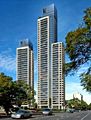 TheLe Parc Figueroa Alcortacondominium towers.
 -
 TheJapanese Gardensand architecture overlooking the avenue.
 -
-
 Cars on Avenida Figueroa Alcorta during noon.


References[edit]
- ^palermonlineArchived2009-03-02 at theWayback Machine(in Spanish)
- ^todopropiedades(in Spanish)ArchivedAugust 28, 2008, at theWayback Machine
- ^"auto-historia"(in Spanish). Archived fromthe originalon 2009-02-21.Retrieved2009-02-21.
- ^sitioriverplatense(in Spanish)ArchivedJuly 25, 2011, at theWayback Machine
- ^Clarín(in Spanish)