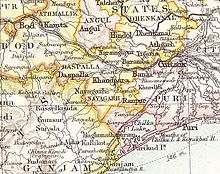
Banki State
| Banki State | |||||||
|---|---|---|---|---|---|---|---|
| Princely StateofBritish India | |||||||
| 1807–1840 | |||||||
 Banki in theImperial Gazetteer of India | |||||||
| Area | |||||||
• 1881 | 300 km2(120 sq mi) | ||||||
| Population | |||||||
• 1881 | 56,900 | ||||||
| History | |||||||
• Established as aBritish protectorate | 1807 | ||||||
• Annexed by theBritish Raj | 1840 | ||||||
| |||||||
| Today part of | Odisha,India | ||||||
BankiorBānki Statewas aprincely stateinOdishaduring theBritish Raj.Its capital wasBanki,in the western part of present dayCuttack district.[1]
The last Raja was arrested for murder and Banki State was subsequentlyannexedby theBritish Raj.Until 1840, it paid an annual tribute of £443.
History
[edit]Banki was azamindaristate ofOrissalocated in the hilly area to the west of Cuttack district. The predecessor state had been ruled by a powerful Raja who in the 17th century had established the zamindari ofDompadaas a gift to his second son.[2]
The riverMahanadiflowed to the north of the state, separating it fromBarambaandTigiria.It was bound in the south byPuri districtand in the west byKhandpara State;a little part of the state was located north of the Mahanadi. The state included 177 villages, the most important of which were Charchika, Baideswar, Kalapathar and Subarnapur.
Banki became aBritish protectoratein 1807 following the defeat of theMaratha Empirein the area. In 1821 it was made part of theFeudatory States of Orissa.[3] The population grew from 49,426 inhabitants in 1872 to 56,900 in 1881, with a density of 377 per square mile in 1901.[4]99.5% of the population were Hindu and the main ethnic group in the hills were theJuang people.[5]
Rulers
[edit]The rulers of Banki State bore the title 'Raja'. In 1840 the last Raja was deposed and the state was confiscated after he was condemned by a British tribunal to life in prison for murder. After annexation Banki was put under direct control of theBengal Presidency,being administered by theCuttackCommissioner.
See also
[edit]References
[edit]- ^Banki, India Page
- ^"Dompada (Zamindari)".Archived fromthe originalon 24 January 2019.Retrieved14 January2016.
- ^L. E. B. Cobden-Ramsay,Feudatory States of Orissa: Bengal District Gazetteers,Logos Press, 2011
- ^Imperial Gazetteer of India, v. 11, p. 89.
- ^Great Britain India Office.The Imperial Gazetteer of India.Trübner & co. London, 1885.
