
Beqaa Valley
This articleneeds additional citations forverification.(May 2024) |
| Beqaa Valley | |
|---|---|
 Grapevines nearKasarnaba,overlooking the central Beqaa Valley | |
| Length | 120 km (75 mi) |
| Width | 16 km (9.9 mi) |
| Naming | |
| Native name | وادي البقاع(Arabic) |
| Geology | |
| Type | Valley |
| Geography | |
| Country | Lebanon |
| State/Province | Baalbek-Hermel Governorate,Beqaa Governorate |
| Population center | Baalbeck |
| Coordinates | 34°00′32″N36°08′43″E/ 34.00889°N 36.14528°E |
TheBeqaa Valley(Arabic:وادي البقاع,Wādī l-Biqā‘,Lebanese[bʔaːʕ];alsotransliteratedasBekaa,Biqâ,andBecaa)is a fertile valley in easternLebanonand its most importantfarming region.[1]The region is known inclassical antiquityasCoele-Syria.Industry also flourishes in Beqaa, especially in the agricultural industry of the country.
The Beqaa is located about 30 km (19 mi) east ofBeirut.The valley is situated betweenMount Lebanonto the west and theAnti-Lebanon mountainsto the east.[2]It is the northern continuation of the Jordan Rift Valley, and thus part of theGreat Rift Valley,which stretches fromSyriato theRed Sea.Beqaa Valley is 120 kilometres (75 mi) long and 16 kilometres (9.9 mi) wide on average. It has aMediterranean climateof wet, often snowy winters and dry, warm summers.[3]
The region receives limited rainfall, particularly in the north, because Mount Lebanon creates arain shadowthat blocks precipitation coming from the sea. The northern section has an average annual rainfall of 230 millimetres (9.1 in), compared to 610 millimetres (24 in) in the central valley.[4]Nevertheless, two rivers originate in the valley: theOrontes(Asi), which flows north into Syria andTurkey,and theLitani,which flows south and then west to the Mediterranean Sea.[2]
From the 1st century BC, when the region was part of theRoman Empire,the Beqaa Valley served as a source of grain for theRoman provincesof theLevant.Today the valley makes up 40 percent of Lebanon'sarable land.[5]The northern end of the valley, with its scarce rainfall and less fertile soils, is used primarily as grazing land bypastoral nomads.Farther south, more fertile soils support crops of wheat,maize,cotton,and vegetables, withvineyardsandorchardscentered onZahlé.The valley also produceshashishand cultivatesopium poppies,which are exported as part of theillegal drug trade.[5]Since 1957 theLitani hydroelectricity project,a series ofcanalsand a dam located atLake Qaraounat the southern end of the valley, has improved irrigation to farms in Beqaa Valley.
History
[edit]Pre-History
[edit]Baalbek,part of a valley to the east of the northern Beqaa Valley shows signs of almost continual habitation over the last 8–9000 years.Ard Tlailiis a small tell mound archaeological site in a plain at the foot of the Lebanon Mountains 11 km (7 mi) northwest of Baalbeck, in the Beqaa Valley in Lebanon. It dates to around 5780-5710 BC and has the southernmost pottery beloning to theHalaf Culture.[6]
Labwehis a village at an elevation of 950 metres (3,120 ft) on a foothill of the Anti-Lebanon Mountains in Baalbek District, Baalbek-Hermel Governorate, Lebanon, settled since theNeolithic.[6]
Bronze Age
[edit]In the Middle Bronze IIA, the Beqa Valley was a highway between the regional power ofQatnain the north and its vassalHazorin the south. The Beqaa valley was known asAmquduring theBronze Age.The identity of the inhabitants is not known for certain, but the region was part of the Amorite Kingdoms ofAmurruandQatna.To the southwest of Baalbek wasEnišasi,a city or city-state mentioned in the1350-1335 BCAmarna letterscorrespondence,written by two rulers of the cityŠatiyaandAbdi-Riša.[7]
Iron Age
[edit]By the earlyIron Age,the Beqaa Valley came to be dominated byPhoenician- andAramaic-speaking populations.
In the 11th and 10th centuries BC, theAramaeansfounded the kingdom ofAram-Zobah(also Sobah), mentioned in theBible.Many scholars suggest it was located in the Beqa'a valley.[8]The precise whereabouts ofZobah,a prominent city at the time, remains a subject of scholarly debate. In the 8th and 7th century BC, Sobah, now underImperial Assyrian rule,served as the residence for an Assyrian governor,Bel-liqbi.[8]
The valley was possibly the birthplace ofHazael,who expanded his domain as far asPalestineand present-day southernTurkey,and may have crossed theEuphrates.
Hellenistic and Roman times
[edit]By the time ofAlexander the Great,the valley was reportedly inhabited by theItureans,possibly an Arabic or Aramaean people. According to theHistories of Alexander the Great,the Itureans were Arab peasants living in the hills aboveTyrewho slaughtered about 30Macedonians,which prompted Alexander to conduct an expedition against them. Later on, the Itureans broke away from the weakenedSeleucid Empireto form theKingdom of Chalcis.
From their base in the Bekaa, the Itureans expanded their territory to include the Phoenician cities of the coast and came close toDamascus.Their territory was eventually absorbed into the rest ofRoman Syria.
The valley was of considerable importance to theRoman Empireas one of the important agricultural regions in the eastern provinces, and it was known for itsmany temples.The region also gained the attention ofPalmyreneQueenZenobia,who built theCanalizations of Zenobia,linking the valley with Palmyra.
Districts and towns
[edit]
Zahleis the largest city and the administrative capital of theBeqaa Governorate.It lies just north of the mainBeirut–Damascushighway, which bisects the valley. The majority of Zahle's residents areLebanese Christian,the majority beingMelkite Greek Catholic,Maronite Catholic,andGreek Orthodox Christians.The town ofAnjar,situated in the eastern part of the valley, has a predominantlyArmenian Lebanesepopulation and is famous for its 8th-centuryArabruins. Further east, the town ofMajdal Anjarhas aSunni Muslimmajority.
The majority of the inhabitants of the northern districts of Beqaa,BaalbekandHermel,areLebanese Shiites,with the exception of the town ofDeir el Ahmar,whose inhabitants areChristians.The Baalbek and Hermel districts have aChristianandSunniminority, mainly situated further north along the border with Syria.
The western and southern districts of the valley also have a mixed population ofMuslims,Christians,andDruze.The town ofJoub Janinewith a population of about 12,000, is situated midway in the valley, and its population isSunni.Joub Janine is the governmental center of the region known as Western Beqaa, with municipal services like theserail,which is the main government building in the area,emergency medical services(Red Cross), afire department,and acourthouse.

Other towns in the Western Beqaa district are Machghara, Sabghine, Kamed al Lawz, Qab Elias, Sohmor, Yohmor. The towns are all a mix of different Lebanese religious confessions.Rachaiya al Wadi,east of the Western Beqaa district, is home to Lebanon's share of Mount Hermon and borders Syria also. The district's capital, also Rachaiya al Wadi, not to be confused withRachaiya al Foukharin South Lebanon, is famous for its old renovated souk and what is known as the castle of independence in which Lebanon's pre-independence leaders were held by French troops before being released in 1943. The southern section of the district is inhabited with Druze and Christian Lebanese, while the other northern section is mainly inhabited by Sunni Lebanese.
Due to wars and the unstable economic and political conditions Lebanon faced in the past, with difficulties some farmers still face today, many previous inhabitants of the valley left for coastal cities in Lebanon or emigrated from the country altogether, with the majority residing in America, South America or Australia.
Landmarks
[edit]
- The ancient Roman ruins ofBaalbek
- Temples of the Beqaa Valley,a collection ofshrinesandRoman temples
- Tomb of Khawla,alleged shrine of Khawla the daughter ofHusayn ibn Ali
- TheUmayyadruins ofAnjar
- Our Lady of Bekaa,aMarian shrine
- TheAammiq Wetlandhabitat for birds and butterflies
- The Roman Grotto underChâteau Ksarawinery
- Lebanon's tallestminaret,inKherbet Rouha
- The Sanctuary of Our Lady of Bechouat
- RomannymphaeumofTemnin el-Foka
- Lake Qaraoun,the largest artificial water reservoir in Lebanon
- Phoenician ruins ofKamid al lawz
- Roman ruins ofLibbaya
- Roman ruins ofQab Elias
- ThePyramid tower of Hermelat the northern end of the valley
- Tomb ofNoahinKarak Nuh,a shrine dedicated to Noah.
Wines
[edit]The Beqaa Valley is home to Lebanon's famous vineyards andwineries.Wine making is a tradition that goes back 6000 years inLebanon.With an average altitude of 1000 m abovesea level,the valley's climate is very suitable to vineyards. Abundant winter rain and much sunshine in the summer helps the grapes ripen easily. There are more than a dozen wineries in the Beqaa Valley, producing over six million bottles a year.[1]Beqaa Valley wineries include:[citation needed]
- Château Ka
- Château Kefraya
- Château Khoury
- Château Ksara[9]
- Château Marsyas
- Château Musar[10]
- Château Qanafar
- Clos Saint Thomas
- Domaine de Baal
- Domaine des Tourelles
- Domaine Wardy[11]
- Kroum Kefraya
- Massaya[12]
- Terre Joie
Illicit drugs
[edit]
Drugs have a long tradition in the Beqaa Valley, from the days of the Roman Empire to the present. Cultivators and tribal drug lords have worked with militias to build up a thriving cannabis trade. The region has been compared to Peru's cocaine producingUpper Huallaga Valley.[13]
During theLebanese Civil War,cannabis cultivationwas a major source of income in the Beqaa valley, where most of the country'shashishandopiumwas produced. The war led various groups to turn todrug traffickingfor income. Syria, which controlled most of the valley, profited significantly from the trade.Palestinianterrorist groups, including thePLO,also participated in the hashish trade, making millions of dollars.[13]
The trade collapsed during theworldwide crackdownon narcotics led by the United States in the early 1990s.[14]Under pressure from the U.S. State Department, the occupying Syrian Army plowed up the Beqaa's cannabis fields and sprayed them with poison. Prior to 1991 it was estimated that income generated from illicit crops grown in the Beqaa was around $500 million. According to theUNDPthe annual per capita income at that time in theBaalbek and Hermeldistrict did not exceed $500. The same agency estimated the figure for the rest of Lebanon was $2,074.[14]
Since the mid-1990s, the culture and production of drugs in the Beqaa valley has been in steady decline. By 2002, an estimated 2,500 hectares[15]of cannabis were limited to the extreme north of the valley, where government presence remains minimal. Every year since 2001 the Lebanese army plows cannabis fields in an effort to destroy the crops before harvest.[16]It is estimated that that action eliminates no more than 30% of overall crops. Although important during the civil war,opiumcultivation has become marginal, dropping from an estimated 30 metric tonnes per year in 1983 to negligible amounts in 2004.
Due to increasing political unrest that weakened the central Lebanese government during the2006 Lebanon Warand 2007 Opposition boycott of the government, and due to the lack of viable alternatives, UN promises of irrigation projects and alternative crop subsidies that never materialised, drug cultivation and production have significantly increased.[17][18]They remain a fraction of the civil war era production and are limited north of the town ofBaalbek,where the rule of tribal law protecting armed families is still strong.
Gallery
[edit]-
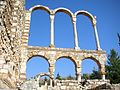 Arches at the ruins of Anjar
 -
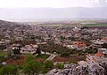
 Road in the Bekaa
 -
 Remains of structures
 -
 Kamid el-Lozvillage


See also
[edit]References
[edit]- ^ab"Global eye – Spring 2006 – Eye on Lebanon – The Bekaa Valley".Archived fromthe originalon October 11, 2006.
- ^abMasri, Rania (1997-01-01),"Environmental Challenges in Lebanon",Challenging Environmental Issues,Brill, pp. 73–115,doi:10.1163/9789004475076_006,ISBN978-90-04-47507-6,retrieved2024-06-10
- ^Neal, Mark (2019-05-23),"Beqaa Valley",A Dictionary of Business and Management in the Middle East and North Africa,Oxford University Press,doi:10.1093/acref/9780191843266.001.0001,ISBN978-0-19-184326-6,retrieved2024-07-29
- ^"Beqaa, LB Climate Zone, Monthly Weather Averages and Historical Data".weatherandclimate.Retrieved2024-07-29.
- ^ab"Lebanon's Neglected Agricultural Potential - a Story of Baalbek".welthungerhilfe.org.tr.Retrieved2024-07-29.
- ^abCopeland, Lorraine (1969).Neolithic Village Sites in the South Beqaa, Lebanon.
- ^Safadi, Crystal (2015)."The Beqa'a Valley During the Early Bronze Age: A GIS Approach to Settlement Patterns".
- ^abAbousamra, Gaby (2019-03-25),"Biblical Ṣobah: a Location Attempt",Aramaean Borders,Brill, pp. 232–233,doi:10.1163/9789004398535_011,ISBN978-90-04-39853-5,retrieved2024-06-10
- ^"chateauksara".Retrieved10 September2013.[permanent dead link]
- ^"Chateau Musar".Retrieved10 September2013.
- ^"Lebanese wine".Domaine Wardy.Retrieved10 September2013.
- ^"Lebanese wine".Massaya.Retrieved10 September2013.
- ^abDavids, Douglas J. (2002-01-01),"Narco-Terrorist Relationships",Narco Terrorism: A Unified Strategy to Fight a Growing Terrorist Menace,Brill Nijhoff, pp. 33–34,doi:10.1163/9789004479555_005,ISBN978-90-04-47955-5,retrieved2024-06-10
- ^abMiddle East InternationalNo 567, 30 January 1998; Reinoud Leenders p.19
- ^"Lebanon".Central Intelligence Agency. September 28, 2022 – via CIA.gov.
- ^United Press International, Feb 26 2002 'Lebanon army destroys drugs'
- ^"Lebanese find troubles fertile ground for cannabis"Reuters
- ^Gustafsson, Jenny (October 2013)."Villages in the Bekaa valley cling to cannabis cultivation as their only means of survival".The Caravan.Retrieved2019-12-30.