
Bethel, Connecticut
Bethel, Connecticut | |
|---|---|
 Greenwood Avenue, a historic street in Bethel. | |
 Flag  Seal | |
  | |
   | |
| Coordinates:41°22′27″N73°23′42″W/ 41.37417°N 73.39500°W | |
| Country | United States |
| U.S. state | Connecticut |
| County | Fairfield |
| Region | Western CT |
| Incorporated | 1855 |
| Government | |
| • Type | Selectman-town meeting |
| • First selectman | Dan Carter (R) |
| • Selectman | Richard C. Straiton (D) |
| • Selectman | Bryan Terzian (R) |
| Area | |
| • Total | 16.9 sq mi (43.8 km2) |
| • Land | 16.8 sq mi (43.5 km2) |
| • Water | 0.1 sq mi (0.2 km2) |
| Elevation | 482 ft (147 m) |
| Population (2022)[1] | |
| • Total | 20,156 |
| • Density | 1,204.6/sq mi (465.1/km2) |
| Time zone | UTC-5(Eastern) |
| • Summer (DST) | UTC-4(Eastern) |
| ZIP Code | 06801 |
| Area codes | 203/475 |
| FIPS code | 09-04720 |
| GNISfeature ID | 213390[2] |
| Website | www |
Bethel(/ˈbɛθəl/) is atowninFairfield County, Connecticut,United States.[2]As of the2020 census,the population of the town was 20,358. The town is part of theWestern Connecticut Planning Region.The town includes theBethel Census-Designated Place.[3]

History[edit]
Bethel was first settled around 1700. The town incorporated in 1855 fromDanbury.Bethel is a name derived from Hebrew meaning "house of God".[4]
The first meeting of theYoung Communist Leaguewas held in Bethel in May 1922.[5]
In 1934, Rudolph Kunett started the firstvodkadistillery in the U.S. after purchasing rights to the recipe from the exiledSmirnofffamily.
Geography[edit]
According to theUnited States Census Bureau,the town has a total area of 16.9 square miles (44 km2), of which 16.8 square miles (44 km2) is land and 0.1 square miles (0.26 km2), or 0.53%, is water. TheBethel CDP,corresponding to the town center, has a total area of 4.1 square miles (11 km2), all land. Bethel bordersReddingto the south,Danburyto the west,Brookfieldto the north, andNewtownto the east.
Demographics[edit]
| Year | Pop. | ±% |
|---|---|---|
| 1860 | 1,711 | — |
| 1870 | 2,311 | +35.1% |
| 1880 | 2,727 | +18.0% |
| 1890 | 3,401 | +24.7% |
| 1900 | 3,327 | −2.2% |
| 1910 | 3,792 | +14.0% |
| 1920 | 3,201 | −15.6% |
| 1930 | 3,886 | +21.4% |
| 1940 | 4,105 | +5.6% |
| 1950 | 5,104 | +24.3% |
| 1960 | 8,200 | +60.7% |
| 1970 | 10,945 | +33.5% |
| 1980 | 16,004 | +46.2% |
| 1990 | 17,541 | +9.6% |
| 2000 | 18,067 | +3.0% |
| 2010 | 18,584 | +2.9% |
| 2020 | 20,358 | +9.5% |
| Source:[6] | ||
As of the 2010 census Bethel had a population of 18,584. The racial and ethnic composition of the population was 88.8% white, 1.8% black or African American, 0.1% Native American, 4.5% Asian, 2.8% from some other race and 1.9% from two or more races. 7.6% of the population was Hispanic or Latino from any race.[7]
As of thecensus[8]of 2000, there were 18,067 people, 6,505 households, and 4,846 families residing in the town. The population density was 1,075.7 inhabitants per square mile (415.3/km2). There were 6,653 housing units at an average density of 396.1 per square mile (152.9/km2). The racial makeup of the town in 2005 was 85.86%White,1.91%African American,0.26%Native American,4.58%Asian,0.04%Pacific Islander,3.20% fromother racesor of multiple races.HispanicorLatinoof any race were 4.33% of the population. 20.2% were ofItalian,17.5%Irish,9.1%German,7.0%English,6.7%Americanand 6.0%Polishancestry according toCensus 2000.[9]88.7% spokeEnglish,4.4%Spanish,3.3%Portuguese,1.5%Germanand 1.0%Frenchas their first language.[10]
There were 6,505 households, out of which 38.6% had children under the age of 18 living with them, 62.4% weremarried couplesliving together, 9.0% had a female householder with no husband present, and 25.5% were non-families. 20.6% of all households were made up of individuals, and 7.7% had someone living alone who was 65 years of age or older. The average household size was 2.76 and the average family size was 3.23.
In the town, the population was spread out, with 27.3% under the age of 18, 6.0% from 18 to 24, 31.9% from 25 to 44, 24.6% from 45 to 64, and 10.2% who were 65 years of age or older. The median age was 37 years. For every 100 females, there were 95.2 males. For every 100 females age 18 and over, there were 92.1 males.
The median income for a household in the town was $68,891, and the median income for a family was $78,358. Males had a median income of $51,816 versus $36,544 for females. Theper capita incomefor the town was $28,927. About 1.2% of families and 2.5% of the population were below thepoverty line,including 1.3% of those under age 18 and 5.5% of those age 65 or over.
Historic pictures[edit]
-
 Bird's eye view,c. 1910
 -
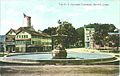 P.T. Barnum Fountain,c. 1914
 -
 Greenwood Avenue,c. 1909
 -
 South Street,c. 1910


Economy[edit]
Battery manufacturerDuracellis headquartered in Bethel.
Arts and culture[edit]

Sites listed on theNational Register of Historic PlacesincludeGreenwood Avenue Historic District,Rev. John Ely House,andSeth Seelye House.
Government[edit]
| Year | Democratic | Republican | Third Parties |
|---|---|---|---|
| 2020 | 56.12%6,270 | 42.37%4,734 | 1.51%168 |
| 2016 | 48.52%4,777 | 46.47%4,575 | 5.02%494 |
| 2012 | 51.18%4,777 | 47.63%4,445 | 1.19%111 |
| 2008 | 53.57%5,179 | 45.20%4,370 | 1.23%119 |
| 2004 | 46.74%4,486 | 51.34%4,927 | 1.92%184 |
| 2000 | 48.50%4,324 | 45.50%4,057 | 6.00%535 |
| 1996 | 46.62%3,883 | 41.69%3,472 | 11.69%974 |
| 1992 | 34.04%3,178 | 42.56%3,974 | 23.40%2,185 |
| 1988 | 36.41%2,924 | 62.43%5,013 | 1.16%93 |
| 1984 | 29.09%2,312 | 70.57%5,610 | 0.34%27 |
| 1980 | 32.24%2,379 | 54.42%4,015 | 13.34%984 |
| 1976 | 41.54%2,640 | 57.67%3,665 | 0.79%50 |
| 1972 | 30.88%1,709 | 67.56%3,739 | 1.55%86 |
| 1968 | 39.80%1,780 | 53.06%2,373 | 7.13%319 |
| 1964 | 65.63%2,731 | 34.37%1,430 | 0.00%0 |
| 1960 | 44.86%1,862 | 55.14%2,289 | 0.00%0 |
| 1956 | 24.59%850 | 75.41%2,607 | 0.00%0 |
| Voter Registration & Party Affiliation as of October 31, 2023[13] | |||||
|---|---|---|---|---|---|
| Party | Active voters | Inactive voters | Total voters | Percentage | |
| Republican | 3,126 | 240 | 3,366 | 23.9% | |
| Democratic | 3,985 | 326 | 4,311 | 30.6% | |
| Unaffiliated | 5,469 | 710 | 6,179 | 43.9% | |
| Minor parties | 199 | 26 | 225 | 1.6% | |
| Total | 12,779 | 1,302 | 14,081 | 100% | |
Education[edit]
Bethel High Schoollocated in Bethel.
Media[edit]
Movies filmed in Bethel[edit]
Films partially shot in Bethel include:Rachel, Rachel(1968),Other People's Money(1991), andRevolutionary Road(2008).[14]
Notable people[edit]
- Raghib Allie-Brennan,member of theConnecticut House of Representatives(raised in Bethel)
- Matt Barnes(born 1990), pitcher for theWashington Nationals
- P. T. Barnum(1810–1891), showman
- Barbara Britton(1919–1980), stage, film and television actress
- Dan Cramer,mixed martial arts fighter for theUltimate Fighting Championship
- Tony Dovolani,ballroom dancer, cast member onDancing with the Stars
- Kevin Gutzman,constitutional scholar and professor of history
- Allan J. Kellogg,Medal of Honorrecipient
- Jan Miner(1917–2004), actress
- Thurston Moore(born 1958), singer and guitarist forSonic Youth[15]
- Noël Regney,composer
- Meg Ryan,actress[16]
- Julius Hawley Seelye(1824–1895), missionary, author, congressman, and former president ofAmherst College[17]
- Glover Teixeira,Professional MMA fighter
- Annamarie Tendler(born 1985), artist
- Henry Arthur "Art" Young(1866–1943), cartoonist
Transportation[edit]

Interstate 84passes through Bethel, and it has atrain stationon theDanbury BranchofMetro-North'sNew Haven Line.[18]The Danbury Branch providescommuter railservice betweenDanbury,toSouth Norwalk,Stamford,andGrand Central TerminalinNew York City.Housatonic Area Regional Transitprovides local bus service.
References[edit]
- ^"Census - Geography Profile: Bethel town, Fairfield County, Connecticut".United States Census Bureau.RetrievedNovember 26,2021.
- ^abU.S. Geological Survey Geographic Names Information System: Town of Bethel
- ^U.S. Geological Survey Geographic Names Information System: Bethel Census Designated Place
- ^The Connecticut Magazine: An Illustrated Monthly.Connecticut Magazine Company. 1903. p. 331.
- ^"YOUNG COMMUNIST LEAGUE/YOUNG WORKERS LEAGUE (1921-1946) organizational history".marxisthistory.org.RetrievedDecember 8,2021.
- ^"Section VII-Local Government".Archived fromthe originalon February 16, 2008.RetrievedMarch 9,2007.
- ^2010 population by race and Hispanic or Latino by place chart for Connecticut from the US Census
- ^"U.S. Census website".United States Census Bureau.RetrievedJanuary 31,2008.
- ^"U.S. Census website".United States Census Bureau.RetrievedMarch 23,2008.
- ^"Data Center Results".
- ^"General Elections Statement of Vote 1922".
- ^"Election Night Reporting".CT Secretary of State.RetrievedDecember 16,2020.
- ^"CT Registration and Party Enrollment Statistics"(PDF).
- ^"Filming Location Matching" Bethel,%20Connecticut,%20USA "(Sorted by Popularity Ascending)".IMDb.
- ^Dixon, Ken, "Music Hall of Fame proposed for state", article inConnecticut Postin Bridgeport, Connecticut, April 26, 2007 ( "Thurston Moore, leader of alt-rock legends Sonic Youth, who grew up in Bethel" )
- ^"What Connecticut was like in 1988".Connecticut Post.March 16, 2015.RetrievedDecember 8,2021.
- ^Shook, J.R.; Hull, R.T. (2005).Dictionary of Modern American Philosophers.The Dictionary of Modern American Philosophers. Thoemmes. p. 2188.ISBN978-1-84371-037-0.RetrievedSeptember 16,2018.
- ^http://as0.mta.info/mnr/stations/station_detail.cfm?key=278"Metro North Railroad Home > Stations Bethel," MTA. Retrieved May 4, 2014.
External links[edit]
Municipalities and communities ofWestern Connecticut Planning Region, Connecticut,United States | ||
|---|---|---|
| Cities |  | |
| Towns | ||


| Topics | |||||||
|---|---|---|---|---|---|---|---|
| States | |||||||
| Major cities | |||||||
| State capitals | |||||||
| Transportation |
| ||||||
| International | |
|---|---|
| National | |
| Geographic | |
| Other | |