
Blue Hill, Maine
Blue Hill, Maine | |
|---|---|
 Blue Hill from Parker Point | |
| Motto(s): "Got lost Blue Hill, Maine" | |
 Blue Hill  Blue Hill | |
| Coordinates:44°24′44″N68°34′25″W/ 44.41222°N 68.57361°W | |
| Country | United States |
| State | Maine |
| County | Hancock |
| Incorporated | 1789 |
| Villages | Blue Hill Blue Hill Falls East Blue Hill North Blue Hill South Blue Hill |
| Government | |
| • Town Administrator | Dr. Nicholas Nadeau |
| Area | |
| • Total | 86.57 sq mi (224.22 km2) |
| • Land | 62.48 sq mi (161.82 km2) |
| • Water | 24.09 sq mi (62.39 km2) |
| Elevation | 46 ft (14 m) |
| Population (2020) | |
| • Total | 2,792 |
| • Density | 45/sq mi (17.3/km2) |
| Time zone | UTC-5(Eastern (EST)) |
| • Summer (DST) | UTC-4(EDT) |
| ZIP code | 04614 |
| Area code | 207 |
| FIPS code | 23-05700 |
| GNISfeature ID | 0582357 |
| Website | Town of Blue Hill, Maine |
Blue Hillis atowninHancock County,Maine,United States, located on Blue Hill Bay. The population was 2,792 at the2020 census.[2]It is home to the Blue Hill Public Library, Blue Hill Memorial Hospital, George Stevens Academy, the Blue Hill Harbor School, The Bay School,New Surry Theatre,Kneisel Hall,Bagaduce Music Lending Library,the Kollegewidgwok Yacht Club, the Shaw Institute and the Blue Hill Country Club. The town also hosts the annual Blue Hill Fair.
History
[edit]It was one of six townships granted by theMassachusetts General Courtto David Marsh and 351 others for their service in theFrench and Indian War.Called Plantation Number 5, it was first settled in 1762 by Captain Joseph Wood and John Roundy fromAndover, Massachusetts,who built homes on Mill Island at the tidal falls. It would then be called Newport Plantation. On January 30, 1789, the town was incorporated as Blue Hill, named after its commanding summit overlooking the region.[3]
The outlets of various ponds provided water power for several sawmills and gristmills. By 1859, 5,000 cords of firewood were sent from the port annually. Other products included lumber, masts and roof shingles, but the predominant industry was shipbuilding. Beginning in 1792, 133 vessels were constructed at Blue Hill, some of them brigs and ships, but most schooners. The town was also noted for the quality of its granite, some of which was used to build theBrooklyn Bridge,New York Stock Exchange Building,and theU.S. Custom HouseatNorfolk, Virginia.In 1876, local quarries employed 300 workers.[4]
AViking pennywas found in 1957 at the nearby prehistoricGoddard archeological siteby local amateur archeologist Guy Mellgren. The coin is believed to be from the 11th century reign ofOlaf Kyrre.
-
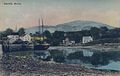 Blue Hillc. 1920
 -
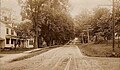 Main Streetc. 1909
 -
 The Elmsc. 1920


Geography
[edit]According to theUnited States Census Bureau,the town has a total area of 86.57 square miles (224.22 km2), of which 62.48 square miles (161.82 km2) is land and 24.09 square miles (62.39 km2) is water.[1]Located on Blue Hill Bay, the town is drained by Mill Brook. Blue Hill, elevation 940 feet (290 meters), is the town's highest point. Long Island, situated in Blue Hill Bay, is part of the town.
Blue Hill is crossed by state routes15,172, 176 and 177. It borders the towns ofSurryto the northeast,Brooklinto the southeast,Sedgwickto the southwest, andPenobscotto the northwest. The town is the site of Blue Hill Airport.
Demographics
[edit]| Census | Pop. | Note | %± |
|---|---|---|---|
| 1790 | 274 | — | |
| 1800 | 494 | 80.3% | |
| 1810 | 658 | 33.2% | |
| 1820 | 957 | 45.4% | |
| 1830 | 1,486 | 55.3% | |
| 1840 | 1,891 | 27.3% | |
| 1850 | 1,939 | 2.5% | |
| 1860 | 1,993 | 2.8% | |
| 1870 | 1,707 | −14.4% | |
| 1880 | 2,213 | 29.6% | |
| 1890 | 1,980 | −10.5% | |
| 1900 | 1,828 | −7.7% | |
| 1910 | 1,462 | −20.0% | |
| 1920 | 1,564 | 7.0% | |
| 1930 | 1,439 | −8.0% | |
| 1940 | 1,343 | −6.7% | |
| 1950 | 1,308 | −2.6% | |
| 1960 | 1,270 | −2.9% | |
| 1970 | 1,367 | 7.6% | |
| 1980 | 1,644 | 20.3% | |
| 1990 | 1,941 | 18.1% | |
| 2000 | 2,390 | 23.1% | |
| 2010 | 2,686 | 12.4% | |
| 2020 | 2,792 | 3.9% | |
| U.S. Decennial Census[5] | |||
2010 census
[edit]As of thecensus[6]of 2010, there were 2,686 people, 1,279 households, and 733 families living in the town. Thepopulation densitywas 43.0 inhabitants per square mile (16.6/km2). There were 1,936 housing units at an average density of 31.0 per square mile (12.0/km2). The racial makeup of the town was 97.3%White,0.4%African American,0.4%Native American,1.1%Asian,0.1% fromother races,and 0.7% from two or more races.HispanicorLatinoof any race were 0.8% of the population.
There were 1,279 households, of which 21.5% had children under the age of 18 living with them, 47.0% weremarried couplesliving together, 7.3% had a female householder with no husband present, 3.0% had a male householder with no wife present, and 42.7% were non-families. 34.1% of all households were made up of individuals, and 16.5% had someone living alone who was 65 years of age or older. The average household size was 2.08 and the average family size was 2.66.
The median age in the town was 49.5 years. 17.5% of residents were under the age of 18; 6.5% were between the ages of 18 and 24; 18.6% were from 25 to 44; 36.8% were from 45 to 64; and 20.7% were 65 years of age or older. The gender makeup of the town was 46.9% male and 53.1% female.
2000 census
[edit]As of thecensus[7]of 2000, there were 2,390 people, 1,074 households, and 681 families living in the town. The population density was 38.2 inhabitants per square mile (14.7/km2). There were 1,486 housing units at an average density of 23.8 per square mile (9.2/km2). The racial makeup of the town was 97.87%White,0.38%African American,0.21%Native American,0.13%Asian,0.08% fromother races,and 1.34% from two or more races.HispanicorLatinoof any race were 0.13% of the population.
There were 1,074 households, out of which 26.2% had children under the age of 18 living with them, 51.1% weremarried couplesliving together, 9.3% had a female householder with no husband present, and 36.5% were non-families. 30.6% of all households were made up of individuals, and 15.5% had someone living alone who was 65 years of age or older. The average household size was 2.23 and the average family size was 2.73.
In the town, the population was spread out, with 21.5% under the age of 18, 6.3% from 18 to 24, 22.9% from 25 to 44, 30.3% from 45 to 64, and 19.0% who were 65 years of age or older. The median age was 45 years. For every 100 females, there were 89.4 males. For every 100 females age 18 and over, there were 85.8 males.
The median income for a household in the town was $31,484, and the median income for a family was $41,688. Males had a median income of $28,200 versus $23,616 for females. Theper capita incomefor the town was $19,189. About 9.3% of families and 13.5% of the population were below thepoverty line,including 17.4% of those under age 18 and 12.8% of those age 65 or over.
Notable people
[edit]- Gerald Warner Brace,author
- Minerva Kline Brooks,campaigner for women's suffrage
- Mary Ellen Chase,author
- George Albert Clough,architect
- A. J. Cronin,author
- Jonathan Fisher,minister
- June Harding,actress, artist
- Effie Hinckley Ober Kline,opera impresario, philanthropist
- Jonathan Lethem,Author
- Bill McHenry,musician
- Nina Milliken,politician and resident of Blue Hill[8]
- Ethelbert Nevin,composer
- Horatio Parker,composer
- Brian D. Rogers,chancellor of theUniversity of Alaska Fairbanks
- Susan Shaw,environmental health scientist, founder of the Shaw Institute (formerly Marine Environmental Research Institute)
- Noel Paul Stookey,musician
- Bertha Tapper,pianist
- Walter C. Teagle,president and chairman atStandard Oil
- Janwillem van de Wetering,author
- Emma Willmann,comedian, actress
- Esther E. Wood,historian, educator, author, and journalist
References
[edit]- ^ab"US Gazetteer files 2010".United States Census Bureau.RetrievedDecember 16,2012.
- ^"Census - Geography Profile: Blue Hill town, Hancock County, Maine".RetrievedJanuary 16,2022.
- ^Coolidge, Austin J.; John B. Mansfield (1859).A History and Description of New England.Boston, Massachusetts. pp. 57–59.
{{cite book}}:CS1 maint: location missing publisher (link) - ^Varney, George J. (1886),Gazetteer of the state of Maine. Blue Hill,Boston: Russell[permanent dead link]
- ^"Census of Population and Housing".Census.gov.RetrievedJune 4,2015.
- ^"U.S. Census website".United States Census Bureau.RetrievedDecember 16,2012.
- ^"U.S. Census website".United States Census Bureau.RetrievedJanuary 31,2008.
- ^"Nina Milliken".Ballotpedia.RetrievedDecember 24,2023.
Further reading
[edit]External links
[edit]Municipalities and communities ofHancock County, Maine,United States | ||
|---|---|---|
| City |  | |
| Towns |
| |
| Unorganized territories | ||
| CDPs | ||
| Other villages | ||
44°24′50″N68°35′12″W/ 44.41389°N 68.58667°W
| International | |
|---|---|
| National | |