Bosut
| Bosut | |
|---|---|
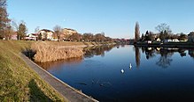
 Bosut betweenRokovciandAndrijaševci | |
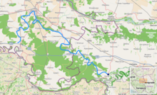
 Bosut location[1] | |
| Location | |
| Countries | |
| Physical characteristics | |
| Source | |
| • location | nearCerna,Croatia |
| • coordinates | 45°05′46″N18°40′36″E/ 45.09611°N 18.67667°E |
| Mouth | |
• location | Savaat thevillage of Bosut,Serbia |
• coordinates | 44°56′28″N19°22′14″E/ 44.9411°N 19.3706°E |
| Length | 186 km (116 mi)[1] |
| Basin size | 2,943 km2(1,136 sq mi)[1] |
| Basin features | |
| Progression | Sava→Danube→Black Sea |
 | |
TheBosut(Serbian Cyrillic:Босут) is a river in theSyrmiaregion of easternCroatiaand northwesternSerbia.It is a 186 km long, slow and meandering left tributary of theSavariver.[2]
The riverbed begins near the left embankment of the Sava river betweenŽupanjaandŠtitar(45°05′46″N18°40′36″E/ 45.09611°N 18.67667°E),[3]which in the past[4][5]was an outflow channel, and a connection with the Sava. Some 2,400 m (1.5 mi) farther, the Bosut gets its first water from theBeravariver (45°06′59″N18°40′45″E/ 45.11639°N 18.67917°E). The narrow riverbed widens inCerna,where it receives the water of theBiđ.[6][3]
The river continues north toward the city ofVinkovci,the only major city on its course, and then turns southeast. NearLipovacit receives its major tributarySpačva,and then enters Serbia nearBatrovci.In its lower course, Bosut flows through a forested area in theSpačva region.
The river is known for its abundance of fish.[7]It is thought that its name derives from the Indo-European root *bhogj, meaning "to flow". The same root is seen in hydronym "Bosna".[8]
Course
[edit]Headwaters
[edit]Since the construction of the Sava river embankment between Štitar and Županja, what used to be a connection with the Sava river and its outflow channel is now a 2,400 m (1.5 mi) bay calledKanal Bosut.There is no significant flow in the channel, so the Bosut River gets its first water from the Berava river, which originates south ofVelika Kopanica,meanders eastwards nearGundinciandBabina Greda,and turns north nearGradište,south ofCerna.It is believed that Bosut was a branch of the Sava or that there was a Roman canal that led from the Sava to the Berava. The narrow riverbed widens in Cerna where the Bosut receives the water of the Biđ, a 66 km (41 mi) long tributary originating in centralSlavoniaregion, on the southern slopes of theDiljmountain.[9]The origin and shape of Bosut, Biđ and their right tributaries are mainly due to the high waters of the Sava and its tributariesBosnaandDrina.The outflow named Bosut was created in the last bend of the great meanders of the Sava, and the surges of water caused the flow to stretch all the way to Vinkovci.[6]
Downstream of Cerna
[edit]
Turning north from Cerna, the river flows into the region ofSyrmia,and the villages ofAndrijaševciandRokovci,reaching the biggest settlement on its course, the city ofVinkovci.From there, the river turns to the southeast, which is the direction it will follow for the rest of its course, except for a large U-bend south of Vinkovci. It passes throughKunjevci,Nijemci,Podgrađe,ApševciandLipovac,where it receives theriver Spačvafrom the right, and after the flow of 151 km through Croatia,[2]crosses the Serbian border.
The Bosut enters Serbia at the village ofBatrovciand flows through the southwesternmost part of the province ofVojvodina.It continues through the villages ofMorović(where it receives the riverStudvafrom the right, its major tributary in Serbia) andVišnjićevo,makes a turn north ofSremska Račaand, after 28 km in Serbia, empties into the Sava at the village ofBosut.ASlezenpond, near Morović, is located in the river's valley.
Characteristics
[edit]
The Bosut belongs to theBlack Seadrainage basin, with its own drainage area of 3,097 km2(1,196 sq mi) (of which 2,572 km2(993 sq mi) in Croatia).[2]For some 40 km it is navigable for smaller vessels.
The river is known as meandering and extremely slow, especially during the summer when the water level can be very low.[6][10]That's why some suggest the origin of the name deriving from theTurkish language:boshfor empty or desolate andsutfor water.[11][3]Due to such a flow, the river has a specific ecosystem, abundant in fish,[7]marsh plants and a deep deposit of silt from their rotting.[10]
The declination in its basin is very small, less than 10 m from Vinkovci until its mouth. Bosut is known as 'the river that flows backwards', because sometimes, with strong winds and being so slow, it appears as if the water is flowing backwards.
It is also known as a region with the highest evaporation in both Croatia and Serbia.[citation needed]In its lower course, Bosut flows through a forested area in theregion of Spačva.
See also
[edit]References
[edit]- ^ab"Sava River Basin Analysis Report"(PDF).International Sava River Basin Commission. September 2009. p. 14. Archived fromthe original(PDF, 9.98 MB)on 2010-07-17.
- ^abcOstroški, Ljiljana, ed. (December 2015).Statistički ljetopis Republike Hrvatske 2015[Statistical Yearbook of the Republic of Croatia 2015](PDF).Statistical Yearbook of the Republic of Croatia (in Croatian and English). Vol. 47. Zagreb:Croatian Bureau of Statistics.p. 49.ISSN1333-3305.Retrieved27 December2015.
- ^abcMarušić, Josip (2017)."Stručni prikaz: Višenamjenski kanal Dunav-Sava. Preduvjet za poboljšanje vodnog režima Bosuta".Hrvatske vode(in Croatian).25(101).
- ^"Slawonische Militärgrenze (1780) - First Military Survey".Arcanum Maps.Retrieved2024-09-25.
- ^"Croatia (1865–1869) - Second military survey of the Habsburg Empire".Arcanum Maps.Retrieved2024-09-25.
- ^abcOrban-Kljajić & Kljajić 2003,p. 599.
- ^ab"Bosut".Hrvatska enciklopedija(in Croatian). Leksikografski zavod Miroslav Krleža.Retrieved2024-09-25.
- ^Mayer, Antun (1935)."Ime Mursa".Vjesnik Arheološkog muzeja u Zagrebu.16(1): 7.Retrieved2022-06-16.
- ^Orban-Kljajić & Kljajić 2003,p. 601.
- ^abĐapo, Almin; Pribičević, Boško; Bulić, Emanuel (2014)."Hydrographic Survey of the River Bed Bosut with Subbottom Profiler to Determine the Thickness of Sedimentary Deposits"(PDF).FIG Congress 2014: Engaging the Challenges – Enhancing the Relevance.
- ^Dukić, Dušan (1952).Naše reke.Izdavačko preduzeće Novo pokolenje. Belgrade
- Orban-Kljajić, Mica; Kljajić, Josip (November 2003)."Statistic description of Brod Regimente in third decade of 19th century".Scrinia Slavonica(in Croatian).3(1).
- Mala Prosvetina Enciklopedija,Third edition (1985); Prosveta;ISBN86-07-00001-2
- Jovan Đ. Marković (1990): "Enciklopedijski geografski leksikon Jugoslavije"; Svjetlost-Sarajevo;ISBN86-01-02651-6


