
Cape Blanco (Oregon)
| Cape Blanco State Park | |
|---|---|
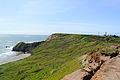
 View from Cape Blanco, looking south towardsPort Orford Heads State Park.Humbug Mountainin the distance. | |
  | |
| Type | Public, state |
| Location | Curry County,Oregon |
| Nearest city | Port Orford |
| Coordinates | 42°50′15″N124°33′50″W/ 42.8376089°N 124.5639997°W[1] |
| Area | 1,880 acres (760 ha) |
| Operated by | Oregon Parks and Recreation Department |
| Visitors | Annually, about 350,000 for day-use, 35,000 overnight[2] |
| Open | Year-round |

Cape Blancois a prominent headland on thePacific Oceancoast of southwesternOregonin the United States, forming the westernmost point in the state.[3]Cape Blanco extends farther west than any point of land in thecontiguous United States(lower 48 states) except portions of theOlympic PeninsulainWashington,includingCape Alava,the true westernmost point.[4]The cape is part ofCape Blanco State Parkand is the location of theCape Blanco Light,first lit in 1870.[3]
The cape may have been named by explorerMartín de Aguilarin 1603 for its appearance, asblancomeans "white" inSpanish.[4][5]In 1775,Juan Francisco de la Bodega y Quadranamed the pointCabo Diligensias.[4]It was later renamedCape Orfordby CaptainGeorge Vancouverin 1792, but this name fell into disuse and Cape Blanco became the common usage.[4]
Geology[edit]
The cape, a relatively level landform with cliffs facing the sea, is about 200 feet (61 m) higher than the ocean. It consists of layers of uplifted marine sediments, ranging in age from 80 million years at the bottom to less than 500,000 years at the top.[4]The uplift is continuing; Cape Blanco is rising by several millimeters each year.[6]Generally, landforms on the north and south end of theOregon Coastare rising as the ocean floor slides under the continent, while the central part of the coast "seems to be folding down."[6]
Landforms near the cape include beaches, bluffs, and reefs. Visible to the south are Needle Rock, Blanco Reef, andHumbug Mountain.To the north are Gull Rock, Castle Rock, and Blacklock Point.[3]Blanco Reef is a group of irregular rocks and ledges that are from 2 to 5 miles (3 to 8 km) offshore and are up to 149 feet (45 m) high.[7]
Geography and climate[edit]
Cape Blanco is in northernCurry County,about 4 miles (6 km) north ofPort Orford,along a mountainous and isolated stretch of the coast bounded to the east by theCoast Range.[8]It lies about 5 miles (8 km) west ofU.S. Route 101.[3]
TheSixes Riverempties into the Pacific Ocean along the north side of the cape.[8]A 2-mile (3 km) walk along theOregon Coast Trailleads south from the park to the mouth of theElk River.[3]
Cape Blanco has very mild temperatures year round, with an all-time record high of only 85 °F (29.4 °C). Annual precipitation is high, but there is a distinct drying trend in summer, which gives Cape Blanco a warm-summerMediterranean climate(Csb) according to theKöppen climate classificationsystem. During winter storms, wind speeds can reach 70 to 100 miles per hour (113 to 161 km/h) at the cape.[9]Extreme winds at the cape and over the Blanco Reef make this part of the coast especially dangerous for ships.[3]
| Climate data for Cape Blanco (1961–1990 normals, extremes 1952–1979) | |||||||||||||
|---|---|---|---|---|---|---|---|---|---|---|---|---|---|
| Month | Jan | Feb | Mar | Apr | May | Jun | Jul | Aug | Sep | Oct | Nov | Dec | Year |
| Record high °F (°C) | 75 (24) |
72 (22) |
67 (19) |
68 (20) |
75 (24) |
71 (22) |
76 (24) |
71 (22) |
79 (26) |
82 (28) |
71 (22) |
70 (21) |
82 (28) |
| Mean maximum °F (°C) | 58.9 (14.9) |
60.6 (15.9) |
59.7 (15.4) |
59.6 (15.3) |
63.0 (17.2) |
64.3 (17.9) |
67.3 (19.6) |
66.6 (19.2) |
68.6 (20.3) |
68.9 (20.5) |
63.4 (17.4) |
58.7 (14.8) |
72.8 (22.7) |
| Mean daily maximum °F (°C) | 50.9 (10.5) |
51.7 (10.9) |
51.7 (10.9) |
52.4 (11.3) |
54.3 (12.4) |
56.6 (13.7) |
58.0 (14.4) |
59.3 (15.2) |
59.3 (15.2) |
57.4 (14.1) |
52.9 (11.6) |
51.5 (10.8) |
54.8 (12.7) |
| Daily mean °F (°C) | 46.1 (7.8) |
47.6 (8.7) |
47.0 (8.3) |
47.7 (8.7) |
50.1 (10.1) |
52.5 (11.4) |
54.1 (12.3) |
55.1 (12.8) |
54.9 (12.7) |
53.0 (11.7) |
50.1 (10.1) |
47.1 (8.4) |
50.4 (10.2) |
| Mean daily minimum °F (°C) | 42.0 (5.6) |
42.7 (5.9) |
42.5 (5.8) |
43.3 (6.3) |
46.0 (7.8) |
48.5 (9.2) |
49.9 (9.9) |
50.9 (10.5) |
50.5 (10.3) |
48.5 (9.2) |
44.1 (6.7) |
42.5 (5.8) |
46.1 (7.8) |
| Mean minimum °F (°C) | 30.8 (−0.7) |
35.5 (1.9) |
34.5 (1.4) |
36.6 (2.6) |
40.4 (4.7) |
44.0 (6.7) |
45.9 (7.7) |
46.6 (8.1) |
45.3 (7.4) |
42.8 (6.0) |
36.7 (2.6) |
33.4 (0.8) |
28.8 (−1.8) |
| Record low °F (°C) | 19 (−7) |
22 (−6) |
25 (−4) |
25 (−4) |
34 (1) |
34 (1) |
41 (5) |
40 (4) |
39 (4) |
39 (4) |
29 (−2) |
17 (−8) |
17 (−8) |
| Averageprecipitationinches (mm) | 13.23 (336) |
10.14 (258) |
9.63 (245) |
5.74 (146) |
3.17 (81) |
1.27 (32) |
0.53 (13) |
1.51 (38) |
2.45 (62) |
5.42 (138) |
12.25 (311) |
14.15 (359) |
79.48 (2,019) |
| Average snowfall inches (cm) | 0.3 (0.76) |
trace | 0 (0) |
trace | 0 (0) |
0 (0) |
0 (0) |
0 (0) |
0 (0) |
0 (0) |
0 (0) |
trace | 0.3 (0.76) |
| Average precipitation days(≥ 0.01 inch) | 17.9 | 16.5 | 16.6 | 14.5 | 10.3 | 6.7 | 3.3 | 4.7 | 6.4 | 10.6 | 18.8 | 19.5 | 145.8 |
| Average snowy days(≥ 0.1 inch) | 0.1 | 0.0 | 0.0 | 0.0 | 0.0 | 0.0 | 0.0 | 0.0 | 0.0 | 0.0 | 0.0 | 0.0 | 0.1 |
| Source 1:WRCC[10] | |||||||||||||
| Source 2: XMACIS (snowfall)[11] | |||||||||||||
Recreation[edit]
Activities at the park include hiking, horseback riding, fishing, camping, picnicking, and beachcombing, among others, and visiting the lighthouse, a pioneer cemetery, or theHughes House,on theNational Register of Historic Places.[3]
The property belonged originally to Patrick Hughes, who came to the cape in 1860 in search of gold and who eventually established a 2,000-acre (810 ha) dairy ranch along the lower Sixes River. Restored by the Friends of Cape Blanco, the two-story, eleven-room ranch house was completed in 1898.[3]
Literature[edit]
InJules Verne's early science fiction bookThe Begum's Millions,aUtopiancommunity named Ville-France is established in 1872 on the South Oregon beach. Verne gives the location of this fictitious community as "eighty kilometres north of Cape Blanco". Cape Blanco is also noted on a map ofBrobdingnaginGulliver's Travels.It is also mentioned in Chapter 3 ofMoby-Dick:"And that harpoon-so like a corkscrew now-was flung in Javan seas, and run away with by a whale, years afterwards slain off the Cape of Blanco."
Gallery[edit]
-
 North side of the Cape
 -
 Cape Blanco and lighthouse
 -
 Cape Blanco looking north towards Gulf Rock, Castle Rock and Floras Lake State Park


See also[edit]
- Cape Blanco (disambiguation)
- Cape Blanco State Airport
- Cape Mendocino
- Extreme points of U.S. states
- List of Oregon state parks
References[edit]
- ^"Cape Blanco State Park".Geographic Names Information System.United States Geological Survey. May 22, 1986.RetrievedNovember 26,2014.
- ^"Cape Blanco State Park: History".Oregon Parks and Recreation Department.RetrievedNovember 26,2014.
- ^abcdefghBannan, Jan (2002).Oregon State Parks: A Complete Recreation Guide(2nd ed.). Seattle: The Mountaineers Books. pp. 37–38.ISBN0-89886-794-0.
- ^abcdeLaLande, Jeff."Cape Blanco".The Oregon Encyclopedia.RetrievedApril 28,2014.
- ^McArthur, Lewis A.;McArthur, Lewis L.(2003) [1928].Oregon Geographic Names(7th ed.). Portland, Oregon:Oregon Historical SocietyPress. pp. 159–160.ISBN978-0875952772.
- ^abBishop, Ellen Morris; Eliot, John (1996).Hiking Oregon's Geology.Seattle: The Mountaineers. p. 52.ISBN0-89886-485-2.
- ^"Booklet Chart: Port Orford to Cape Blanco"(PDF).National Oceanic and Atmospheric Administration. p. 2. Archived fromthe original(PDF)on December 19, 2014.RetrievedNovember 27,2014.
- ^abOregon Road and Recreation Atlas(5th ed.). Santa Barbara, California: Benchmark Maps. 2012. p. 82.ISBN978-0-929591-62-9.
- ^Palmer, Tim (2014).Field Guide to Oregon Rivers.Corvallis: Oregon State University Press. p. 114.ISBN978-0-87071-627-0.
- ^"1961-1990 Monthly Climate Summary, CAPE BLANCO, OREGON (351360)".Western Regional Climate Center.Archived fromthe originalon January 29, 2024.RetrievedJanuary 29,2024.
- ^XMACIS
External links[edit]
- "Cape Blanco".Geographic Names Information System.United States Geological Survey,United States Department of the Interior.RetrievedNovember 16,2008.
- Cape Blanco Heritage Society
| International | |
|---|---|
| Other | |