
Cape Cod Canal
| Cape Cod Canal | ||||||||||||||||||||||||||||||||||||||||||||||||||||||||||||||||
|---|---|---|---|---|---|---|---|---|---|---|---|---|---|---|---|---|---|---|---|---|---|---|---|---|---|---|---|---|---|---|---|---|---|---|---|---|---|---|---|---|---|---|---|---|---|---|---|---|---|---|---|---|---|---|---|---|---|---|---|---|---|---|---|---|
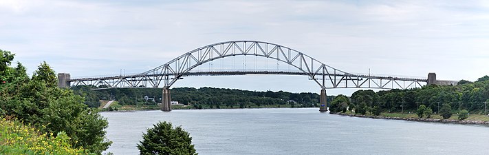
 TheBourne Bridgewith theCape Cod Canal Railroad Bridgein distance | ||||||||||||||||||||||||||||||||||||||||||||||||||||||||||||||||
 Location of the Cape Cod Canal | ||||||||||||||||||||||||||||||||||||||||||||||||||||||||||||||||
| Location | Barnstable County, Massachusetts | |||||||||||||||||||||||||||||||||||||||||||||||||||||||||||||||
| Country | United States | |||||||||||||||||||||||||||||||||||||||||||||||||||||||||||||||
| Coordinates | 41°45′51″N70°34′6″W/ 41.76417°N 70.56833°W | |||||||||||||||||||||||||||||||||||||||||||||||||||||||||||||||
| Specifications | ||||||||||||||||||||||||||||||||||||||||||||||||||||||||||||||||
| Length | 7.4 miles (11.9 km) | |||||||||||||||||||||||||||||||||||||||||||||||||||||||||||||||
| Maximumboat length | 825 feet (251 m)[1] | |||||||||||||||||||||||||||||||||||||||||||||||||||||||||||||||
| Maximumboat draft | 32 feet (9.8 m)[1] | |||||||||||||||||||||||||||||||||||||||||||||||||||||||||||||||
| Maximumboat air draft | 135 feet (41 m)[1] | |||||||||||||||||||||||||||||||||||||||||||||||||||||||||||||||
| Locks | None | |||||||||||||||||||||||||||||||||||||||||||||||||||||||||||||||
| Status | Open | |||||||||||||||||||||||||||||||||||||||||||||||||||||||||||||||
| Navigation authority | U.S. Army Corps of Engineers | |||||||||||||||||||||||||||||||||||||||||||||||||||||||||||||||
| History | ||||||||||||||||||||||||||||||||||||||||||||||||||||||||||||||||
| Original owner | Cape Cod & New York Canal Company | |||||||||||||||||||||||||||||||||||||||||||||||||||||||||||||||
| Principal engineer | William Barclay Parsons | |||||||||||||||||||||||||||||||||||||||||||||||||||||||||||||||
| Construction began | June 22, 1909 | |||||||||||||||||||||||||||||||||||||||||||||||||||||||||||||||
| Date of first use | July 29, 1914 | |||||||||||||||||||||||||||||||||||||||||||||||||||||||||||||||
| Geography | ||||||||||||||||||||||||||||||||||||||||||||||||||||||||||||||||
| Start point | Cape Cod Bay | |||||||||||||||||||||||||||||||||||||||||||||||||||||||||||||||
| End point | Buzzards Bay | |||||||||||||||||||||||||||||||||||||||||||||||||||||||||||||||
| ||||||||||||||||||||||||||||||||||||||||||||||||||||||||||||||||
TheCape Cod Canalis an artificial waterway inMassachusettsconnectingCape Cod Bayin the north toBuzzards Bayin the south, and is part of theAtlantic Intracoastal Waterway.The approximately 7.4-mile-long (11.9 km) canal traverses the neck of land joiningCape Codto the state's mainland. It mostly follows tidal rivers widened to 480 feet (150 m) and deepened to 32 feet (9.8 m) at mean low water, shaving up to 135 miles (217 km) off the journey around the cape for its approximately 14,000 annual users.[2]
Most of the canal is located in the town ofBourne,but its northeastern terminus is inSandwich.Scusset Beach State Reservationlies near the canal's north entrance, and theMassachusetts Maritime Academyis near its south. A swift-running current changes direction every six hours and can reach 5.2 miles per hour (8.4 km/h) during the receding ebb tide.
The waterway is maintained by theUnited States Army Corps of Engineersand has no toll fees.[3]It is spanned by theCape Cod Canal Railroad Bridge,theBourne Bridge,and theSagamore Bridge.Traffic lights at either end govern the approach of vessels over 65 feet (20 m).
The canal is occasionally used by whales and dolphins,[4]including endangeredNorth Atlantic right whales,which can cause closure of the canal.[5][6]
History
[edit]
Construction of a canal was first considered byMyles Standishof thePlymouth Colonyin 1623, and thePilgrimsscouted the low-lying stretch of land between the Manomet[a]and Scusset rivers for potential routes.William Bradfordestablished theAptucxet Trading Postin 1627 at the portage between the rivers. Trade prospered with the Indians ofNarragansett Bayand the Dutch ofNew Netherland,and this was a major factor enabling the Pilgrims to pay off their debt.[8]
In 1697, theGeneral Court of Massachusettsconsidered the first formal proposal to build the canal but took no action.[9]In 1717, a canal was created inOrleans, MassachusettscalledJeremiah's Gutterwhich spanned a narrower portion of the Cape some distance to the east, but it remained active only until the late 1800s. More energetic planning with surveys took place repeatedly in 1776 (commissioned byGeorge Washington),[10]1791,[11]1803, 1818, 1824–1830, and 1860. None of these efforts came to fruition.[citation needed]
The first attempts at actually building a canal did not take place until the late 19th century; earlier planners either ran out of money or were overwhelmed by the project's size. The engineers finally decided which route to take through the hillsides by connecting and widening the Manomet and Scusset rivers. The first excavation began in 1880, when the Cape Cod Ship Canal Company hired 400 immigrant Italian laborers to begin digging with shovels and wheelbarrows. The effort ran out of money almost immediately, and the laborers were unpaid and forced to beg for food inSandwich.In 1883, the Cape Cod Ship Canal Company reorganized under engineer Frederick Lockwood. The company used a bucket dredge to clear nearly a mile of channel through the Sandwich marshes before shutting down in 1891.[12]
Private construction
[edit]
On June 22, 1909, construction finally began for a working canal under the direction ofAugust Belmont Jr.'s Boston, Cape Cod & New York Canal Company, using designs by engineerWilliam Barclay Parsons.The canal engineers encountered many problems, such as huge boulders underwater. Divers were hired to blow them up, but the effort slowed dredging. Another problem was cold winter storms which forced the engineers to stop dredging altogether and wait for spring.[13]Nevertheless, the canal opened on a limited basis on July 29, 1914,[14]and it was completed in 1916. The privately owned toll canal had a maximum width of 100 feet (30 m) and a maximum depth of 25 feet (7.6 m), and it took a somewhat difficult route from Phinney Harbor at the head of Buzzards Bay.[15]Several accidents occurred due to the narrow channel and navigation difficulty, and these limited traffic and tarnished the canal's reputation. Toll revenues failed to meet investors' expectations as a result, despite shortening the trade route from New York City to Boston by 62 miles (100 km).[16]
Public takeover and expansion
[edit]
On July 25, 1918, the Director General of theUnited States Railroad Administrationtook over jurisdiction and operation of the canal under a presidential proclamation. Four days earlier, the German U-boatU-156surfaced three miles (5 km) offOrleans, Massachusettson July 21, 1918, andshelledthe tugboatPerth Amboyand her string of four barges. The canal remained under government control until 1920, during which theUnited States Army Corps of Engineersre-dredged the channel to 25 feet (7.6 m) deep.
In 1928, the government purchased the canal for $11.4 million as a free public waterway, and $21 million was spent between 1935 and 1940 increasing the canal's width to 480 feet (150 m) and its depth to 32 feet (9.8 m).[17]As a result, it became the widest sea-level canal of its time.[18]The southern entrance to the canal was rebuilt for direct access from Buzzards Bay rather than through Phinney Harbor. Before construction began, theMassachusetts Institute of Technologybuilt a huge scale model of the canal (9 feet to a mile, roughly1⁄587actual size) to study the hydraulic effects of tidal currents on the enlarged and rerouted canal.[19]
World War II
[edit]DuringWorld War II,shipping again used the canal to avoid U-boats patrolling offshore. It was protected by coastal artillery batteries at theSagamore Hill Military Reservationat the northern entrance and theButler Point Military Reservationat the southern entrance. The artillery was never fired in defense of the canal.[20][21]
TheMystic Steamship Company's collier SSStephen R. Joneswas grounded and sank in the canal on June 28, 1942. Shipping was routed around Cape Cod, and theLiberty shipSSAlexander Macombwas torpedoed by the German submarineU-215on July 3 with the loss of ten lives. The canal reopened on July 31 after the wreckedStephen R. Joneswas removed with the help of 17 tons of dynamite.[22]
Recreational uses
[edit]The canal is used extensively by recreational and commercial vessels. Service roads on both sides of the canal provide access for fishing and are heavily used by in-line skaters, bicyclists, and walkers. Several parking areas are maintained at access points. Bourne Scenic Park is leased by the Corps of Engineers to the Town of Bourne Recreation Authority for use as a tent and RV campground adjacent to the Canal.[23]
The Army Corps of Engineers maintains the Cape Cod Canal Visitor Center which introduces visitors to the history, features, and operation of the canal. Features include a retired 41-foot (12 m) US Army Corps of Engineers patrol boat, a 46-seat theater showing continuous DVD presentations on canal history, canal flora and fauna, real time radar and camera images of the waterway, and a variety of interactive exhibits. Corps Park Rangers staff the center and provide free public programs on a variety of subjects. The Visitor Center is open seasonally from May to October, and admission is free. It is located on Moffitt Drive in Sandwich near the canal's east end. A second seasonally staffed center is at the Herring Run along Scenic Highway.[24]
Scusset Beach State Reservationlies just north of the east end of the canal and offers beach facilities as well as tent and RV camping. A 0.7-mile (1.1 km) trail there leads to Sagamore Hill, once an Indian meeting ground and the site of a World War II coastal fortification.[23]Bournedale Hills Trail extends 1.4 miles (2.3 km) along the north side of the Canal from Bourne Scenic Park campground to the Herring Run. The trail includes a 0.8-mile (1.3 km) self-guided loop which interprets the Canal's historic and natural features.[23]
Tunnel folklore and proposal
[edit]A spoof became popular during the late 20th century concerning a fictitious road tunnel, allegedly built in the 1960s, under the Cape Cod Canal.[25]It came into popular usage in Massachusetts as a commentary on the severe traffic entering and exiting Cape Cod during the summer months. Since 1994, decals have been sold in shops around the Cape as popular souvenirs purporting to be "permits" allowing the bearer to use the tunnel; the popularity of these "permits" briefly led to a lawsuit among several different sellers.[26][27]In 2019, theMassachusetts Department of Transportation(MassDOT) said that it had studied the idea of adding a tunnel, but had no plans to do so.[28]
Gallery
[edit]- Cape Cod Canal
-

-

-
-
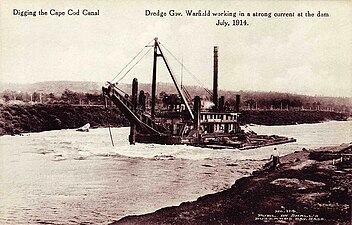 TheGov. Warfielddigging the canal in 1914
 -
 A 1922 map of the Cape Cod Canal, showing bridges, mooring points, and other features


See also
[edit]Notes
[edit]References
[edit]- ^New England District (November 12, 2015)."Cape Cod Canal (Buzzards Bay and Sandwich, Mass.)".U.S. Army Corps of Engineers.RetrievedFebruary 24,2016.
- ^Pearson, Samantha."Dolphins in Cape Cod Canal Saturday"(Video). Boston:WBZ-TV.
- ^Bragg, Mary Ann (May 9, 2015)."Cape Cod Canal closed after right whale sighting".Cape Cod Times.
- ^"Favorite Places".Archived fromthe originalon September 8, 2008.
- ^Ritt, Glenn (January 18, 2016)."A history of the Cape Cod Canal".capecodmuseumtrail.RetrievedMay 16,2023.
- ^Reid, William J. (August 1965). "The Military Value of the Cape Cod Canal".United States Naval Institute Proceedings.p. 83.
- ^Conway, J. North (2008).The Cape Cod Canal: Breaking Through the Bared and Bended Arm.Arcadia Publishing Incorporated. p. 16.ISBN9781625843821.
- ^Conway (2008),p. 18.
- ^Conway (2008),p. 20.
- ^Timothy, Orwig (2013).Cape Cod Canal.Arcadia Publishing. pp. 20–22.ISBN9781467120364.
- ^New England District."Cape Cod Canal".US Army Corps of Engineers. Archived fromthe originalon December 5, 2003.
- ^"The Story of the Week: Opening the Cape Cod Canal".The Independent.Vol. 79, no. 3423. July 20, 1914. p. 88.RetrievedFebruary 24,2016– via Archive.org.
- ^"Massachusetts Estuaries Project – Map & List of Targeted Estuaries".Massachusetts Department of Environmental Protection. Archived fromthe originalon June 9, 2012.RetrievedAugust 10,2012.
- ^"The Opening of the Cape Cod Canal".Bulletin of the American Geographical Society.Vol. 46, no. 11. 1914. pp. 832–834.doi:10.2307/200951.JSTOR200951.
- ^Reid (1965),pp. 85–86.
- ^"Cape Cod Canal at Army Corps of Engineers website".Archived fromthe originalon June 18, 2009.RetrievedMay 23,2009.
- ^"Model of Cape Cod Canal Helps Study of Channel".Popular Mechanics.April 1936. p. 567 – viaGoogle Books.
- ^"Sagamore Hill Military Reservation".American Forts Network.
- ^"Butler Point Military Reservation".American Forts Network.
- ^Reid (1965),pp. 89–90.
- ^abcNew England District."Recreation Along the Cape Cod Canal".U.S. Army Corps of Engineers. Archived fromthe originalon November 28, 2009.RetrievedOctober 31,2009.
- ^"Cape Cod Canal (Buzzards Bay and Sandwich, Mass.), New England District".U.S. Army Corps of Engineers.RetrievedJuly 27,2018.
- ^"Cape Cod Canal".New England Travel Planner.
- ^Carroll, Felix (October 2, 1999)."A case of tunnel vision".Cape Cod Times.
- ^Carlson, James (September 3, 2004)."Sticking around".Cape Cod Times.
- ^DeCosta-Klipa, Nik (May 24, 2019)."Why MassDOT dismissed the idea of a Cape Cod tunnel".Local news.The Boston Globe.RetrievedJanuary 12,2023– via Boston.
Officials say tunnels pose a lot more challenges compared to bridges, even if people keeping asking.
Further reading
[edit]- Butler, Gerald (2002).The Military History of the Cape Cod Canal.Charleston, SC: Arcadia Publishing.ISBN0738510092.OCLC0738510092.
- Massachusetts General Court Joint Committee on Ship Canal to Connect Barnstable Bay and Buzzard's Bay (1864).Report of the Joint Committee of 1860 upon the Proposed Canal to Unite Barnstable and Buzzard's Bays(Report). Boston: Wright & Potter, State Printers. pp. 10–22.RetrievedJuly 24,2014.
- Reid, William James (1961).The Building of the Cape Cod Canal, 1627–1914.New York: Privately printed.LCCN61-15903.OCLC987742.
External links
[edit]| International | |
|---|---|
| National | |
| Other | |
- Cape Cod Canal
- 1914 establishments in Massachusetts
- Belmont family
- Bodies of water of Barnstable County, Massachusetts
- Bourne, Massachusetts
- Canals in Massachusetts
- Canals opened in 1914
- Historic Civil Engineering Landmarks
- Intracoastal Waterway
- Massachusetts culture
- Sandwich, Massachusetts
- Ship canals
- Tourist attractions in Barnstable County, Massachusetts
- Transportation buildings and structures in Barnstable County, Massachusetts
- United States Army Corps of Engineers
- Water transportation in Massachusetts