
Castellinaldo d'Alba
Castellinaldo d'Alba | |
|---|---|
| Comune di Castellinaldo d'Alba | |
 Coat of arms | |
Location of Castellinaldo d'Alba  | |
 Castellinaldo d'Alba Location of Castellinaldo d'Alba in Italy  Castellinaldo d'Alba Castellinaldo d'Alba (Piedmont) | |
| Coordinates:44°47′N8°2′E/ 44.783°N 8.033°E | |
| Country | Italy |
| Region | Piedmont |
| Province | Province of Cuneo(CN) |
| Area | |
| • Total | 7.9 km2(3.1 sq mi) |
| Population (Dec. 2004)[2] | |
| • Total | 881 |
| • Density | 110/km2(290/sq mi) |
| Demonym | Castellinaldesi |
| Time zone | UTC+1(CET) |
| • Summer (DST) | UTC+2(CEST) |
| Postal code | 12050 |
| Dialing code | 0173 |
Castellinaldo d'Albais acomune(municipality) in theProvince of Cuneoin theItalianregionPiedmont,located about 40 kilometres (25 mi) southeast ofTurinand about 60 kilometres (37 mi) northeast ofCuneo.As of 31 December 2004, it had a population of 881 and an area of 7.9 square kilometres (3.1 sq mi).[3]
Castellinaldo borders the following municipalities:Canale,Castagnito,Magliano Alfieri,Priocca,andVezza d'Alba.
Demographic evolution
[edit]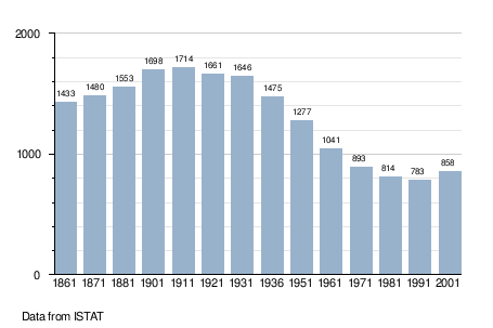
References
[edit]- ^"Superficie di Comuni Province e Regioni italiane al 9 ottobre 2011".Italian National Institute of Statistics.Retrieved16 March2019.
- ^"Popolazione Residente al 1° Gennaio 2018".Italian National Institute of Statistics.Retrieved16 March2019.
- ^All demographics and other statistics: Italian statistical instituteIstat.
This article on a location in the Province of Cuneo is astub.You can help Wikipedia byexpanding it. |