
Charpa Falls
| Charpa Falls | |
|---|---|
 The Milky Charpa Falls | |
 | |
 | |
| Location | Thrissur District,Kerala,India |
| Coordinates | 10°18′16″N76°34′47″E/ 10.30455°N 76.57981°E |
| Watercourse | Chalakkudi River |
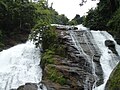
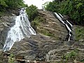
Charpa Fallsis a waterfall located inAthirappillypanchayathinThrissur districtofKerala.Located on the west-flowingChalakudy River,this waterfall lies in between the more famousAthirappilly FallsandVazhachal Falls.[1]It is a popular stopover for tourists who are visiting the Athirappilly and Vazhachal Falls. It is located close to the road,[2]and during monsoon months (June to August), the water splashes onto the road.[3]During the dry season, the water stops flowing.
Gallery
[edit]-
 A view of the waterfall
 -
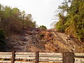 Waterfall during the dry season
 -
 Charpa
 -
 Charpa Falls
 -
 Charpa Falls


See also
[edit]- Athirappilly Falls
- Vazhachal Falls
- Chalakudy
- List of waterfalls in India
- List of waterfalls in India by height
References
[edit]Wikimedia Commons has media related toCharpa Falls.
- ^Sajith (9 May 2009)."Kerala tourism: Vazhachal falls & Charpa falls".Keralatourism-kns.blogspot.in.Retrieved5 September2012.
- ^"Waterfalls - Charpa Falls - Tourist Information of India - Lakes, Waterfalls, Beaches, Monuments, Museums, Places, Cities - By".Tripsguru. Archived fromthe originalon 16 May 2012.Retrieved5 September2012.
- ^MustSeeIndia."Thrissur: Charpa Falls, Thrissur Tourist Places to Visit for".Mustseeindia. Archived fromthe originalon 10 October 2012.Retrieved5 September2012.
Tourist attractions inThrissur | ||
|---|---|---|
| Dams |  | |
| Beaches and waterfalls | ||
| Forts and palaces | ||
| Boatraces | ||
| Parks and zoos | ||
| Exhibitions and film festivals | ||
| Buildings | ||
| Festivals | ||
| Prehistoric | ||
| Museums | ||