
Core Banks, North Carolina
 | |
 Core Banks | |
| Geography | |
|---|---|
| Location | SouthernOuter Banks,Carteret County, North Carolina,United States |
| Coordinates | 34°42′23″N76°27′32″W/ 34.70639°N 76.45889°W |
| Administration | |
United States | |
| Nearest city | Harkers Island, NC |
| Governing body | National Park Service |
| Demographics | |
| Population | no permanent population |
| Pop. density | 0/km2(0/sq mi) |
TheCore Banksarebarrier islandsinNorth Carolina,part of theOuter BanksandCape Lookout National Seashore.Named after theCoreetribe, they extend fromOcracoke InlettoCape Lookout,and consist of two low-relief narrow islands,North Core BanksandSouth Core Banks,and, since September 2011, two smaller islands.New Drum Inlet,Old Drum Inlet and Ophelia Inlet now separate the islands. The Core Banks are now uninhabited. However,Portsmouth,at the north end of the North Core Banks, was once a substantial port, andCape Lookout Village,about one and half miles south of theCape Lookout Lighthouse,contains the historic Lookout Life-Saving Station, aU.S. Coast Guard Station,and several island homes.
Access
[edit]Islands can be reached by two vehicle ferries. One ferry crossesCore SoundfromAtlanticto North Core Banks, and another crosses the sound fromDavisto South Core Banks. There are no roads on the islands: vehicles use the beach and four wheel drive tracks. Passenger ferries also take tourists fromHarkers Islandto the Cape Lookout area at the south end of South Core Banks.[1]
Portsmouth Island, on whichPortsmouth Villagestands, is a tidal island accessible from North Core Banks at most states of the tide.
History
[edit]TheCape Lookout Coast Guard Station,Cape Lookout Light Station,andCape Lookout Village Historic Districtare listed on theNational Register of Historic Places.[2]
Geography
[edit]
The geography of the Core Banks has changed since the mid 19th century. At that time South Core Banks was connected to theShackleford Banks.Over the years inlets have closed and opened in the barrier islands. From north to south these inlets have been Whalebone Inlet, now closed, which separated Portsmouth Island from the Core Banks, Swash Inlet (closed), Old Drum Inlet (closed in 1971 and reopened byHurricane Irenein 2011), New Drum Inlet (opened by theU.S. Army Corps of Engineersin 1971), Ophelia Inlet (opened byHurricane Opheliain 2005[3]), Cedar Inlet (closed) andBarden Inlet(opened by ahurricane in 1933,separating Shackleford Banks from South Core Banks).[4]
From northeast to southwest, the islands are located in theTownshipsof Portsmouth, Atlantic,Sea Level,Stacy, Davis, Smyrna, and Harkers Island, all inCarteret County.
Climate
[edit]According to theTrewartha climate classificationsystem, Core Banks, North Carolina has ahumid subtropical climatewith hot and humid summers, cool winters and year-around precipitation (Cfak). Cfak climates are characterized by all months having an average mean temperature > 32.0 °F (> 0.0 °C), at least eight months with an average mean temperature ≥ 50.0 °F (≥ 10.0 °C), at least one month with an average mean temperature ≥ 71.6 °F (≥ 22.0 °C) and no significant precipitation difference between seasons. During the summer months in Core Banks, a cooling afternoonsea breezeis present on most days, but episodes of extreme heat and humidity can occur withheat indexvalues ≥ 100 °F (≥ 38 °C). Core Banks is prone to hurricane strikes, particularly during theAtlantic hurricane seasonwhich extends from June 1 through November 30, sharply peaking from late August through September. During the winter months, episodes of cold and wind can occur withwind chillvalues < 10 °F (< -12 °C). Theplant hardiness zonein Core Banks is 8b with an average annual extreme minimum air temperature of 15.3 °F (-9.3 °C).[5]The average seasonal (Dec-Mar) snowfall total is < 2 inches (< 5 cm), and the average annual peak innor'easteractivity is in February.
| Climate data for Core Banks, NC (1981-2010 Averages) | |||||||||||||
|---|---|---|---|---|---|---|---|---|---|---|---|---|---|
| Month | Jan | Feb | Mar | Apr | May | Jun | Jul | Aug | Sep | Oct | Nov | Dec | Year |
| Mean daily maximum °F (°C) | 52.8 (11.6) |
54.4 (12.4) |
60.0 (15.6) |
67.1 (19.5) |
74.1 (23.4) |
80.9 (27.2) |
83.9 (28.8) |
83.2 (28.4) |
79.7 (26.5) |
71.9 (22.2) |
64.5 (18.1) |
56.2 (13.4) |
69.1 (20.6) |
| Daily mean °F (°C) | 45.6 (7.6) |
47.4 (8.6) |
53.1 (11.7) |
60.7 (15.9) |
68.4 (20.2) |
76.1 (24.5) |
79.4 (26.3) |
78.5 (25.8) |
74.5 (23.6) |
65.4 (18.6) |
57.4 (14.1) |
49.1 (9.5) |
63.0 (17.2) |
| Mean daily minimum °F (°C) | 38.5 (3.6) |
40.5 (4.7) |
46.2 (7.9) |
54.4 (12.4) |
62.6 (17.0) |
71.2 (21.8) |
74.9 (23.8) |
73.8 (23.2) |
69.4 (20.8) |
59.0 (15.0) |
50.3 (10.2) |
41.9 (5.5) |
57.0 (13.9) |
| Averageprecipitationinches (mm) | 4.54 (115) |
3.68 (93) |
4.44 (113) |
3.34 (85) |
4.20 (107) |
4.45 (113) |
5.98 (152) |
7.25 (184) |
6.59 (167) |
4.51 (115) |
4.05 (103) |
4.01 (102) |
57.04 (1,449) |
| Averagerelative humidity(%) | 72.9 | 73.6 | 72.0 | 72.7 | 74.8 | 77.9 | 80.8 | 79.2 | 78.3 | 75.4 | 76.0 | 74.4 | 75.7 |
| Averagedew point°F (°C) | 37.4 (3.0) |
39.4 (4.1) |
44.3 (6.8) |
51.9 (11.1) |
60.1 (15.6) |
68.7 (20.4) |
73.0 (22.8) |
71.5 (21.9) |
67.3 (19.6) |
57.4 (14.1) |
49.9 (9.9) |
41.3 (5.2) |
55.3 (12.9) |
| Source: PRISM[6] | |||||||||||||
| Climate data for Cape Hatteras, NC Ocean Water Temperature (64 NE Core Banks) | |||||||||||||
|---|---|---|---|---|---|---|---|---|---|---|---|---|---|
| Month | Jan | Feb | Mar | Apr | May | Jun | Jul | Aug | Sep | Oct | Nov | Dec | Year |
| Daily mean °F (°C) | 49 (9) |
46 (8) |
52 (11) |
59 (15) |
68 (20) |
74 (23) |
78 (26) |
80 (27) |
77 (25) |
70 (21) |
58 (14) |
55 (13) |
64 (18) |
| Source: NOAA[7] | |||||||||||||
Ecology
[edit]According to theA. W. KuchlerU.S.potential natural vegetationtypes, Core Banks, North Carolina would have a dominant vegetation type ofLive oak/Sea OatsUniola paniculata(90) with a dominant vegetation form ofCoastalPrairie(20).[8]
Gallery
[edit]-
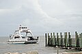 Access by ferry
 -
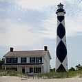 Cape Lookout Lighthouseand Keeper's Quarters.
 -
 View fromCape Lookout Lighthouselooking North East
 -
-
 Portsmouthchurch
 -
 BodyboardingnearGreat Islandcabins
 -
 Surf fishing
 -
 Recreational vehiclecustomized for beach driving and surf fishing.
 -
![In 1976, about 1,500 vehicles were removed from the island.[9] Few remain.](https://upload.wikimedia.org/wikipedia/commons/thumb/0/0e/Core_Banks_cars_-_2013-06_-_1.JPG/120px-Core_Banks_cars_-_2013-06_-_1.JPG) In 1976, about 1,500 vehicles were removed from the island.[9]Few remain.
In 1976, about 1,500 vehicles were removed from the island.[9]Few remain. -
![Many shipwreck remains can be found on the beaches[10]](https://upload.wikimedia.org/wikipedia/commons/thumb/4/48/Core_Banks_shipwreck_-_2013-06_-_3.JPG/120px-Core_Banks_shipwreck_-_2013-06_-_3.JPG) Many shipwreck remains can be found on the beaches[10]
Many shipwreck remains can be found on the beaches[10] -
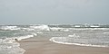 Confusing wave patterns at the beach at Cape Lookout point. Waves are coming from several directions.
 -
 Fires are allowed on the beach


![In 1976, about 1,500 vehicles were removed from the island.[9] Few remain.](/translate/en.wikipedia.org?u=https%3A%2F%2Fen.wikipedia.org%2Fwiki%2FFile%3ACore_Banks_cars_-_2013-06_-_1.JPG&t=vi)
![Many shipwreck remains can be found on the beaches[10]](/translate/en.wikipedia.org?u=https%3A%2F%2Fen.wikipedia.org%2Fwiki%2FFile%3ACore_Banks_shipwreck_-_2013-06_-_3.JPG&t=vi)


References
[edit]- ^Cape Lookout National Seashore: Ferry Services
- ^"National Register Information System".National Register of Historic Places.National Park Service.July 9, 2010.
- ^David J. Mallinson; et al. (2008)."Past,Present and Future Inlets of the Outer Banks Barrier Islands, North Carolina"(PDF).Archived fromthe original(PDF)on 2011-10-16.Retrieved2011-06-13.page 12
- ^Barrier Island Ecology of Cape Lookout National Seashore, NPS Scientific Monograph No.9, Chapter 3
- ^"USDA Interactive Plant Hardiness Map".United States Department of Agriculture.RetrievedAugust 6,2019.
- ^"PRISM Climate Group, Oregon State University".RetrievedAugust 6,2019.
- ^"Water Temperature Table of All Coastal Regions".RetrievedAugust 6,2019.
- ^"U.S. Potential Natural Vegetation, Original Kuchler Types, v2.0 (Spatially Adjusted to Correct Geometric Distortions)".RetrievedAugust 6,2019.
- ^The Dispatch; Jun 25, 1976
- ^Surface Interval Diving Company (SIDCO)."The 2002 and 2005 Core Banks Beach Wreck Survey(s)".Archived fromthe originalon 2011-10-14.Retrieved2 August2013.