Crudwell
| Crudwell | |
|---|---|
| Village | |
 Footbridge near the A429 | |
Location withinWiltshire | |
| Population | 1,057 (in 2011)[1] |
| OS grid reference | ST953928 |
| Unitary authority | |
| Ceremonial county | |
| Region | |
| Country | England |
| Sovereign state | United Kingdom |
| Post town | Malmesbury |
| Postcode district | SN16 |
| Dialling code | 01666 |
| Police | Wiltshire |
| Fire | Dorset and Wiltshire |
| Ambulance | South Western |
| UK Parliament | |
| Website | Parish Council |
Crudwellis a village andcivil parishin northWiltshire,England. The nearest towns areMalmesbury,about 4 miles (6.4 km) to the south-west, andCirencester,Gloucestershire8 miles (13 km) to the north-east. Also to the north-east isCotswold Airport.Kemblevillage, about 4 miles (6.4 km) away, has the nearestrailway station,with services toLondon PaddingtonandGloucester.
Links and extent
[edit]The village lies on theA429linking Cirencester and Malmesbury. This route south to Malmesbury opened as aturnpikein 1778.[2]
The parish includes the hamlets of Chedglow, Chelworth, Eastcourt, Murcott and West Crudwell. TheFosse Way,originally a Roman road, forms part of the parish and county boundary. The population of the parish changed little between 1831 (604) and 1951 (618).[1]
History
[edit]TheDomesday Bookof 1086 recorded a large population of 107 households at Crudwell, and smaller settlements at Chelworth and Chedglow.[3]Most of the parish belonged toMalmesbury Abbey's Brokenborough estate, which in the 13th century had a farmstead with a fishpond and a chapel.[2]A large barn still stands to the south of All Saints' Church, probably dating from the 15th century and nowGrade II* listed.[4]
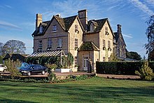
Manor Farm, east of the church, is probably from the 17th century, with additions in the 18th.[5]The old rectory, now a hotel, is from the early 18th century, altered in the late 19th.[6]
A school was founded at Crudwell in the 17th century byLord Lucas.The schoolroom and schoolhouse of 1670 survive in residential use, south-west of the church.[7]A new school was built in 1857, alongside the older buildings, became aNational School,and then in 1949 avoluntary controlledschool.[8]A small school also opened at Eastcourt in about 1858 and became a National School. It closed in 1923 due to falling pupil numbers.[2]
RAF Kemble opened in 1938 in the north of the parish[2]and now serves asCotswold Airport.It was a base for aircraft maintenance and ferrying, and later the home of theRed Arrowsaerobatics display team. In the 1980s the airfield became a maintenance base for the US Air Force. Military flying ended in 1993 when the site was used to store surplus equipment. It was sold into private ownership in 2001 and now houses businesses carrying out aircraft maintenance and dismantling, and technical training.
Parish church
[edit]
TheChurch of England Parish Churchof All Saints, probably begun in the 11th century, is aGrade I listedbuilding.[9][10]Work from the 12th–15th centuries can be seen, with alterations and restoration in the 17th and 19th.[11]
The 15th-century stained glass in a north-east window depicts theseven sacraments.[9]The tower has five bells, recast in 1858 byMears.[9]
In 1151 the church belonged toMalmesbury Abbey,andHankertonChurch was dependent on it, but became a separate parish in 1445.[2]The rectories of Crudwell andSt James, Ashley(Gloucestershire) were united in 1954,[12]and in 1987 the two churches joined withHankertonandOakseyto form the Braydon Brook group.[13]
Amenities
[edit]
The village school, extended in 1969, continues as CrudwellCEPrimary School. Crudwell has two pubs,The Potting Shedand theWheatsheaf Inn,and two hotels,Mayfield House HotelandThe Rectory;the latter is a Grade II listed building.[6]The village also has a village hall and recreation ground, as well as a post office (housed within theWheatsheaf Inn).
Of several annual village events, the two largest are the Crudwell Bike Ride (June), a 24-hour "Le Mans" style event that raises funds for the local village hall, and the Strawberry Fair (July), held on and around the village green. Both take up a weekend and attract visitors from outside the village.
Notable people
[edit]In birth order:
- George Ingram(1694–1763), rector from 1719 until his death[14]
- Ambrose McEvoy(1878–1927), artist[15]
- Walter Knight-Adkin(1880–1957), Chaplain of the Fleet[16]
- Richard Cooper(1945–1990), cricketer
- John Rawling Todd(1929–2002), colonial administrator inBritish Indian Ocean TerritoryandHong Kong[17]
References
[edit]- ^ab"Wiltshire Community History – Census".Wiltshire Council.Retrieved8 January2015.
- ^abcdeBaggs, A. P.; Freeman, Jane; Stevenson, Janet H (eds.)."Victoria County History – Wiltshire – Vol 14 pp. 51–65 – Parishes: Crudwell".British History Online.University of London.Archivedfrom the original on 8 January 2015.Retrieved21 May2016.
- ^Crudwellin theDomesday Book
- ^Historic England."Barn to the south-west of Manor Farmhouse (1181760)".National Heritage List for England.Retrieved24 May2016.
- ^Historic England."Manor Farmhouse (1022233)".National Heritage List for England.Retrieved24 May2016.
- ^abHistoric England."Crudwell Court (1022234)".National Heritage List for England.Retrieved24 May2016.
- ^Historic England."School House and School Cottage (1022235)".National Heritage List for England.Retrieved24 May2016.
- ^"Crudwell Church of England Primary School".Wiltshire Community History.Wiltshire Council.Retrieved23 May2016.
- ^abc"All Saints Church, Crudwell".Wiltshire Community History.Wiltshire Council.Retrieved21 May2016.
- ^Historic England."Church of All Saints (1363888)".National Heritage List for England.Retrieved21 May2016.
- ^"All Saints, Crudwell: About".Retrieved21 May2016.
- ^"No. 40176".The London Gazette.18 May 1954. p. 2918.
- ^"Braydon Brook Churches".Retrieved21 May2016.
- ^"Ingram, George (1718–1763) (CCEd Person ID 50600)".The Clergy of the Church of England Database 1540–1835.Retrieved27 July2017.
- ^Claude Johnson, ed.,The Works of Ambrose McEvoy from 1900 to May 1919,1919.
- ^"No. 33506".The London Gazette.14 June 1929. p. 3943.
- ^"Deaths",Hatfield Record,2004, p. 105.
External links
[edit]![]() Media related toCrudwellat Wikimedia Commons
Media related toCrudwellat Wikimedia Commons
- "Crudwell".Wiltshire Community History.Wiltshire Council.Retrieved15 April2023.
- Crudwell community website
- Crudwell Parish Council
- Crudwell Village Hall and Recreation Ground

