
Harrison, Maine
Harrison, Maine | |
|---|---|
 The Ballroom (2014) | |
 Location inCumberland Countyand the state ofMaine. | |
| Coordinates:44°6′14″N70°39′12″W/ 44.10389°N 70.65333°W | |
| Country | United States |
| State | Maine |
| County | Cumberland |
| Incorporated | 1805 |
| Villages | Harrison Bolsters Mills |
| Area | |
| • Total | 36.81 sq mi (95.34 km2) |
| • Land | 33.19 sq mi (85.96 km2) |
| • Water | 3.62 sq mi (9.38 km2) |
| Elevation | 577 ft (176 m) |
| Population (2020) | |
| • Total | 2,447 |
| • Density | 74/sq mi (28.5/km2) |
| Time zone | UTC-5(Eastern (EST)) |
| • Summer (DST) | UTC-4(EDT) |
| ZIP code | 04040 |
| Area code | 207 |
| FIPS code | 23-31600 |
| GNISfeature ID | 0582513 |
| Website | www |
Harrisonis a town inCumberland County,Maine,United States. Harrison is included in theLewiston-Auburn,Maine metropolitan New England city and town area. The population was 2,447 at the2020 census.[2]A historic resort area, Harrison straddlesLong Lakeand Crystal Lake. It is part of thePortland–South Portland–Biddeford,Mainemetropolitan statistical area.
History[edit]
TheMassachusetts General Courtgranted Otis Field Plantation in 1771 toJames Otisand other heirs of Captain John Gorham and his company for their service in the 1690Battle of Quebec.It replaced a 1736 grant which had been ruled invalid. In 1797, the plantation was incorporated asOtisfield.On March 8, 1805, Harrison was set off and incorporated from portions of Otisfield andBridgton.It was named after a principal landowner,Harrison Gray OtisofBoston,the heir of James Otis.[3]
In the autumn of 1792, two brothers fromGorham,John and Nathan Carsley, built a camp and cleared land in Harrison. During the winter they returned to Gorham, coming back in March 1793 with their wives. Because John Carsley and his wife remained in Harrison when Nathan Carsley and his wife resumed living in Gorham until 1796, he is considered the town's first permanent settler. More pioneers arrived, living inlog houseschinked withmoss.The outlet of Crystal Lake into Long Lake providedwater powerfor industry, and James Sampson erected at Harrison village the firstsawmillandgristmill.Over the years other industries followed, including a wire-making business,blacksmithy,shinglemill,harness-maker,foundry,carriagemaker,clothingmaker andshoeshop. Scribner's Mill (now a museum) was built in 1847 on theCrooked River.On the Bear River, in 1867 the Harrison Water Power Company established the Bear River Woolen Mill, destroyed by fire in 1872.[4]
In 1832, theCumberland and Oxford Canalopened, connectingPortlandwithSebago Lake.A series of 27lockslifted vessels from sea level atCasco Bayto Sebago Lake, 270 feet (82 m) above sea level. From there they traveled up theSongo RivertoBrandy Pond,then continued along theChute Riverto Long Lake. As the company name indicates, the canal was originally planned to reachOxford County,but instead terminated at Harrison. The town became a center for trade and transportation, withwharvesandwarehouseslining the shore.[4]

In 1847, the Sebago & Long Pond Steam Navigation Company builtFawn,the firststeamboatto ply the lakes and waterways. It had a shallowdraftto navigate the winding Songo River, with passengers asked to shift sides asballastto keep bothpaddlewheelsin the water around sharp curves. The lakes became a popular summer tourist destination, with The Elm House (later called The Elms Inn) opening in 1860. When thePortland and Ogdensburg Railroadcommenced service toSebago Lake Stationin 1870, the canal was abandoned as obsolete. Beginning in 1898, theBridgton and Saco River Railroad,anarrow gaugeline, delivered freight and passengers directly to Harrison.
In 1906, the Harrison Hotel opened. Camp Kineo operated beside Long Lake as a camp for boys. Today, Harrison remains a recreational area. Harrison is also home toFernwood Cove,a half-season summer camp for girls on the same spot as Camp Chickawah was. It is located on Island Pond.[5]
In 1936 the Historic Deertrees Theatre was built by Enrica Clay Dillon and is still home to countless theatre, opera and music performances, including the Sebago Long Lake Music Festival.
-
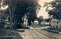 Main Street in 1912
 -
 Camp Kineo in 1914
 -
 The Elms Inn in 1910


Geography[edit]
According to theUnited States Census Bureau,the town has a total area of 36.81 square miles (95.34 km2), of which 33.19 square miles (85.96 km2) is land and 3.62 square miles (9.38 km2) is water.[1]Harrison is drained by the Bear River andCrooked River.
The Maine state routes that cross through Harrison are35and117.Harrison is bordered by the town ofBridgtonto its west,WaterfordandNorwayto its north,Otisfieldto its east, andNaplesto its south.
Crystal Lake[edit]
| Crystal Lake | |
|---|---|
 Crystal Lake | |
| Coordinates | 44°07′N70°40′W/ 44.117°N 70.667°W[6] |
| Primary outflows | Long Lake |
| Basincountries | United States |
| Max. length | 1.5 mi (2.4 km)[7] |
| Surface area | 446 acres (180 ha)[8] |
| Max. depth | 65 feet (20 m)[9] |
| Water volume | 14,254acre⋅ft(17,582,000 m3)[8] |
| Surface elevation | 308 ft (94 m)[6] |
Crystal Lake (formerlyAnonymous Pond) is north of Long Lake, and overflows into Long Lake through downtown Harrison.[7]Smallmouth bassthrive in the lake, with a fewlake trout.[9]
Demographics[edit]
| Census | Pop. | Note | %± |
|---|---|---|---|
| 1810 | 439 | — | |
| 1820 | 789 | 79.7% | |
| 1830 | 1,068 | 35.4% | |
| 1840 | 1,243 | 16.4% | |
| 1850 | 1,416 | 13.9% | |
| 1860 | 1,251 | −11.7% | |
| 1870 | 1,219 | −2.6% | |
| 1880 | 1,168 | −4.2% | |
| 1890 | 1,071 | −8.3% | |
| 1900 | 969 | −9.5% | |
| 1910 | 967 | −0.2% | |
| 1920 | 901 | −6.8% | |
| 1930 | 966 | 7.2% | |
| 1940 | 1,026 | 6.2% | |
| 1950 | 1,026 | 0.0% | |
| 1960 | 1,014 | −1.2% | |
| 1970 | 1,045 | 3.1% | |
| 1980 | 1,667 | 59.5% | |
| 1990 | 1,951 | 17.0% | |
| 2000 | 2,315 | 18.7% | |
| 2010 | 2,730 | 17.9% | |
| 2020 | 2,447 | −10.4% | |
| U.S. Decennial Census[10] | |||
2010 census[edit]
As of thecensus[11]of 2010, there were 2,730 people, 1,113 households, and 779 families living in the town. Thepopulation densitywas 82.3 inhabitants per square mile (31.8/km2). There were 1,761 housing units at an average density of 53.1 per square mile (20.5/km2). The racial makeup of the town was 97.4%White,0.3%African American,0.7%Native American,0.2%Asian,0.3% fromother races,and 1.1% from two or more races.HispanicorLatinoof any race were 0.9% of the population.
There were 1,113 households, of which 29.6% had children under the age of 18 living with them, 55.6% weremarried couplesliving together, 8.7% had a female householder with no husband present, 5.7% had a male householder with no wife present, and 30.0% were non-families. 23.0% of all households were made up of individuals, and 8.5% had someone living alone who was 65 years of age or older. The average household size was 2.45 and the average family size was 2.84.
The median age in the town was 45.3 years. 21.3% of residents were under the age of 18; 5.2% were between the ages of 18 and 24; 23.2% were from 25 to 44; 35% were from 45 to 64; and 15.5% were 65 years of age or older. The gender makeup of the town was 51.3% male and 48.7% female.
2000 census[edit]
As of thecensus[12]of 2000, there were 2,315 people, 920 households, and 662 families living in the town. The population density was 70.1 inhabitants per square mile (27.1/km2). There were 1,430 housing units at an average density of 43.3 per square mile (16.7/km2). The racial makeup of the town was 98.79%White,0.52%African American,0.04%Native American,0.04%Pacific Islander,and 0.60% from two or more races.HispanicorLatinoof any race were 0.52% of the population.
There were 920 households, out of which 32.7% had children under the age of 18 living with them, 57.1% weremarried couplesliving together, 9.3% had a female householder with no husband present, and 28.0% were non-families. 22.6% of all households were made up of individuals, and 9.6% had someone living alone who was 65 years of age or older. The average household size was 2.52 and the average family size was 2.90.
In the town, the population was spread out, with 25.4% under the age of 18, 5.7% from 18 to 24, 28.6% from 25 to 44, 27.1% from 45 to 64, and 13.3% who were 65 years of age or older. The median age was 40 years. For every 100 females, there were 96.9 males. For every 100 females age 18 and over, there were 96.0 males.
The median income for a household in the town was $35,478, and the median income for a family was $42,159. Males had a median income of $30,726 versus $22,311 for females. Theper capita incomefor the town was $17,898. About 6.9% of families and 9.3% of the population were below thepoverty line,including 9.8% of those under age 18 and 5.9% of those age 65 or over.
Notable people[edit]
- Horace A. Barrows,a 19th-century physician, maker of plant-based medicines and advocate of vegetarian diet who invested in the building of the Barrows-Scribner's Mills sawmill andScribner Homestead
- Edward H. Hill,founder ofCentral Maine Medical Center
- Melville E. Ingalls,Massachusetts state legislator and railroad president
- George Lakin,US senator fromWisconsinandUnited States District Attorney
References[edit]
- ^ab"US Gazetteer files 2010".United States Census Bureau.RetrievedDecember 16,2012.
- ^"Census - Geography Profile: Harrison town, Cumberland County, Maine".United States Census Bureau.RetrievedJanuary 16,2022.
- ^Coolidge, Austin J.; John B. Mansfield (1859).A History and Description of New England.Boston, Massachusetts: A.J. Coolidge. p.154.
coolidge mansfield history description new england 1859.
- ^abAlphonso Moulton, Howard L. Sampson and Granville Fernald,Centennial History of Harrison, Maine,1909; published by the Southworth Printing Company, Portland, Maine
- ^Reverend G. T. Ridlon,History of the Settlement and Early Settlers of Harrison, Maine,1877; Published by Kilby & Woodbury; Skowhegan, Maine 1877
- ^abU.S. Geological Survey Geographic Names Information System: Crystal Lake
- ^abThe Maine Atlas and Gazetteer(Thirteenth ed.). Freeport, Maine: DeLorme Mapping Company. 1988. p. 10.ISBN0-89933-035-5.
- ^abMaine Depts. of Environmental Protection and Inland Fisheries & Wildlife (August 4, 2005)."Maine Lakes: Morphometry and Geographic Information".Senator George J. Mitchell Center for Environmental and Watershed Research, TheUniversity of Maine.Archived fromthe originalon September 3, 2006.RetrievedJuly 31,2008.
- ^ab"Crystal Lake"(PDF).Maine Department of Inland Fisheries and Wildlife.State of Maine.RetrievedMay 17,2016.
- ^"Census of Population and Housing".Census.gov.RetrievedJune 4,2015.
- ^"U.S. Census website".United States Census Bureau.RetrievedDecember 16,2012.
- ^"U.S. Census website".United States Census Bureau.RetrievedJanuary 31,2008.
Further reading[edit]
- Ward, Ernest E. (1967).My First Sixty Years in Harrison, Maine.Denmark, Maine: Cardinal Printing.OCLC430144.
External links[edit]
- Town of Harrison official website
- Harrison Village Library
- Deertrees Theatrehttp:// deertrees-theatre.org
- Harrison Friendly Riders Snowmobile Club
- Harrison at Maine.GovArchivedOctober 26, 2007, at theWayback Machine
- Epodunk Town ProfileArchivedAugust 22, 2007, at theWayback Machine
- Maine Genealogy: Harrison, Cumberland County, Maine
Municipalities and communities ofCumberland County, Maine,United States | ||
|---|---|---|
| Cities |  | |
| Towns | ||
| CDPs | ||
| Other villages | ||
44°06′37″N70°40′45″W/ 44.11028°N 70.67917°W
| International | |
|---|---|
| National | |