
Cumlosen
Cumlosen | |
|---|---|
Location of Cumlosen within Prignitz district  | |
 Cumlosen  Cumlosen | |
| Coordinates:53°01′59″N11°40′00″E/ 53.03306°N 11.66667°E | |
| Country | Germany |
| State | Brandenburg |
| District | Prignitz |
| Municipal assoc. | Lenzen-Elbtalaue |
| Subdivisions | 3Ortsteile |
| Government | |
| •Mayor(2024–29) | Harald Pohle[1] |
| Area | |
| • Total | 21.85 km2(8.44 sq mi) |
| Elevation | 20 m (70 ft) |
| Population (2022-12-31)[2] | |
| • Total | 719 |
| • Density | 33/km2(85/sq mi) |
| Time zone | UTC+01:00(CET) |
| • Summer (DST) | UTC+02:00(CEST) |
| Postal codes | 19322 |
| Dialling codes | 038794 |
| Vehicle registration | PR |
| Website | cumlosen.de |

Cumlosenis amunicipalityin thePrignitzdistrict, inBrandenburg,Germany.
History
[edit]Between 1945 and 1990 Cumlosen served as East Germaninner German bordercrossing forinland navigationon theElbe.The crossing was open for freight vessels navigating betweenCzechoslovakia,theSoviet Zone of occupation in Germany(till 1949, thereafter the EastGerman Democratic Republic,orWest Berlinand the British zone of occupation (till 1949) and thereafter the West GermanFederal Republic of Germany.The traffic was subject to theInterzonal trafficregulations and that between West Germany and West Berlin was subject to the special regulations of theTransit Agreement (1972).[3]
Demography
[edit]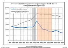
|
|
References
[edit]- ^Landkreis Prignitz Wahl der Bürgermeisterin / des Bürgermeisters.Retrieved 10 July 2024.
- ^"Bevölkerungsentwicklung und Bevölkerungsstandim Land Brandenburg Dezember 2022"(PDF).Amt für Statistik Berlin-Brandenburg(in German). June 2023.
- ^"Seite wird geladen"(PDF).statistik-berlin-brandenburg.de.Retrieved2023-05-18.
- ^Detailed data sources are to be found in the Wikimedia Commons.Population Projection Brandenburg at Wikimedia Commons
Towns and municipalities inPrignitz | ||
|---|---|---|
 | ||
| International | |
|---|---|
| National | |
ThisBrandenburglocation article is astub.You can help Wikipedia byexpanding it. |