Daba Mountains
| Daba Mountains | |
|---|---|
| Dabashan | |
 On top of the Shennong Peak | |
| Highest point | |
| Elevation | 3,105 m (10,187 ft) |
| Prominence | Shennong Ding |
| Naming | |
| Native name | Xe buýt sơn(Chinese) |
| Geography | |
| Daba Mountains | |||||||||
|---|---|---|---|---|---|---|---|---|---|
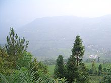
 Morning in Xiqiuwan inBadong County | |||||||||
| Chinese | Xe buýtSơn | ||||||||
| Literal meaning | GreatBaMountain(s) | ||||||||
| |||||||||

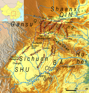
TheDaba Mountains,also known by theirChinesename as theDabashan,[a]are a mountain range in Central China between the watersheds of theYellowandYangtze Rivers.Part of the largerQinling mountain range,it cuts through four provinces:Sichuan,Chongqing,Shaanxi,andHubei.It spans about 1,000 kilometers (620 mi).
Geography[edit]
The Daba Mountains run in the general west-northwest to east-southeast direction, along the border between, on the one side (southwest and south)SichuanandChongqing,and on the other side (northeast and north)ShaanxiandHubei.The mountains ofShennongjiaare often considered the easternmost section of the Daba Range.
The southern slope of the Daba Mountains drains into theSichuan Basinor directly into the Yangtze via short streams that flow into the river in theThree Gorgesarea, such as theShen Nong Stream.The northern side drains into theHan River,a major tributary of the Yangtze, which, however, does not join the Yangtze until some hundreds kilometers to the east (inWuhan).
The Daba Mountains' highest points are in the ShennongjiamassifinShennongjiaForest District. The three tallest peaks, located west ofMuyutown, are Shennong Deng ( "Shennong Peak", 3,105 meters (10,187 ft) elevation), Da Shennongjia ( "Great Shennongjia", 3,052 meters (10,013 ft)), and Xiao Shennongjia ( "Lesser Shennongjia", 3,005 meters (9,859 ft), on the district's border withBadong County). Laojun Shan, 2,936 meters (9,633 ft) tall, is located northeast of Muyu.
In the southeast, the Daba Mountains are joined to theWu Mountains,which block the Yangtze's flow out of theSichuan Basin.In the east, the smallJingshan Range(in the southern part of theXiangyangPrefecture) can be viewed as the extreme extension of the Daba Mountains. In the northeast, theWudang Mountainsare nearby; some authors even consider them a "branch" of the Daba Mountains.[2]
In the rural counties of southernHanzhong,in Shaanxi Province, there is a large area ofkarstwith some of the largestsinkholesin the world, known as theShaanxi tiankeng clusteror "Hanzhong tiankeng group". It covers nearly 5019 square kilometers[3]and is located in four counties,Ningqiang County,Nanzheng County,Xixiang County,andZhenba County,with the largest sinkhole (520 meters in diameter and 320 meters deep), near Sanyuanzhen (Tam nguyên trấn) in Zhenba County.[4]
Natural environment[edit]
The natural landscape of the region, theDaba Mountains evergreen forests,is listed by theWorld Wildlife Fund (WWF)as one of the world's200 ecoregionsthat should be a priority for conservation.[5]Dabashan National Nature Reserveis located in the Chongqing part of the Daba Mountains (Chengkou County); Shennongjia Mountain Nature Reserve (704 square kilometers (272 sq mi)[5]), inHubei(ShennongjiaForestry District).
TheDawn Redwood(Metasequoia glyptostroboides) is a deciduous conifer endemic to the Daba Shan, whose nearest living relatives are theCoast RedwoodandGiant Sequoiaof California. Redwoods formerly ranged across the northern hemisphere, but were thought to be extinct outside California until stands of Dawn Redwood were discovered in the Daba Shan in the 1940s.[5]
Plants of the Daba Mountains
-
A forest mushroom (nearMuyu,Shennongjia)
-
Decaisneainsignis(at about 2,000 meters (6,600 ft) elevation, north of Muyu)
-
Hostaventricosa
-
Chinese red pine (Pinus tabuliformis), inXingshan County
-
Cunninghamia lanceolata(center), inBadong County
Land use[edit]
Presently, terraced agriculture is expanded in the Daba Mountains. A widely planted cash crop is theEucommiatree, a medicinal plant.[6]
Notes[edit]
- ^In the 19th century, the range was also known as theKew-lung[why?]orPo-mung.[1]The latter name refers toMount Bozhong,the source of theHan River.InChinglishsources, the range is also sometimes referenced as "Mount Daba" or "Daba Mountain", owing to confusion arising from the general lack of plural forms in Chinese.
References[edit]
- ^"China",Encyclopædia Britannica,9th ed., Vol. V,1878.
- ^"Wudang Mountains",Atlas of World Heritage: China,Long River Press, 2008, pp. 89–90,ISBN1-59265-060-0
- ^"Thiểm Tây phát hiện thiên hố đàn địa chất di tích đồng phát hiện hiếm thấy thực vật cùng phi miêu"[Tiankeng group of geological relics with rare plants and flying cats found in Shaanxi]. Sohu Inc.Archivedfrom the original on 25 November 2016.
- ^"Thời sự tin tức -- giải mật Hán Trung thiên hố đàn —— viết lại địa chất lịch sử thế giới cấp" tự nhiên viện bảo tàng ""[Deciphering the Hanzhong tiankeng group — world-class "Nature Museum" ]. Hanzhong People's Municipal Government. 25 November 2016.Archivedfrom the original on 27 November 2016.
- ^abc"Daba Mountains evergreen forests".Terrestrial Ecoregions.World Wildlife Fund.Retrieved5 June2011.
- ^Saint-Pierre, Claude (1999), "Building a shared view of future land-use in a project area: terraced agroecosystems in China and the Philippines", in Price, Martin F. (ed.),Global change in the mountains,Informa Health Care, pp. 180–181,ISBN1-85070-062-1


