
Dangri
| Tangri river Dangri river | |
|---|---|
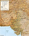
 Ghaggar-Hakra ( "Sarasvati" ) rivers and tributaries | |
| Location | |
| Country | India |
| Physical characteristics | |
| Source | |
| • location | Shivalik Hills,Himachal Pradesh |
| Length | 70 km (43 mi) |
| Discharge | |
| • location | Ghaggar riverinHaryana |
| Basin features | |
| Cities | Ambala Cantt |
| Tributaries | |
| • right | Balaiali river, Amri river (Dadri river or Shahzadpur Wali river) |
| Bridges | Ambala cantt bridge, Barwala bridge, Ambala railway bridge |
TheTangri River,also called theDangri River,which originates in theShivalik Hills,is a tributary of theGhaggar Riverin theHaryanastate ofIndia.[1][2]
Origin and route
[edit]The Tangri river originates in theShivalik hillson the border ofHaryanaandHimachal PradeshState, and flows along the Haryana andPunjabborder before meeting with theGhaggar riverat the confluence.[3]The basin is classified in two parts,Khadir and Bangar,the higher area that is not flooded in rainy season is calledBangarand the lower flood-prone area is calledKhadar.[3]
TheDangriorTangriis a stream that rises in theMorni Hillsof theSiwalik Hillsof south-easternHimachal Pradeshin India,[4]and flows for 70 km in Haryana.[5]It joins theMarkanda River (Haryana)at the Haryana-Punjab border north of Sadhpur Viran in the northwest of theKurukshetra districtand south of Mehmudpur Rurki in southPatiala district.The combined Dangir-Markandastream merges with theSarsuti Riverin northeastKaithal district,east of Diwana and southwest of Adoya, before joining theGhaggarriver just east of Dhandota village nearKasolitown in northwest Kaithal.[4]It is thereafter known as theGhaggar.Further downstream on the banks of the Ghaggar stands an old derelict fort atSirsatown named Sarsuti.[4]After theOttu barrage,the Ghaggar river is called the Hakra River and in Sindh it is called the Nara River. The order of rivers from left to right is the Ghaggar, Dangri, Markanda and Sarsuti. Further left to the right, theChautangandSomb riversare tributaries of the Yamuna.
It is believed that Sarsuti is a corruption of the wordSarasvatiand that the 6–8 km wide channel of the Sarsuti–Ghaggar system might have once been theSarasvati Rivermentioned in theRig Veda.[4][6]This Sarsuti channel is currently being revived by theGovernment of Haryanaas the ancient Sarasvat river.
Tributaries
[edit]
Originating from the Morni Hills, the Tangri joins its southern tributary called theBalaiali River(which originates near the south of the Morni Hills) near Chajju Majra, south ofKharar.Near Panjokhra, southeast of Ambala, the Tangri River divides into two streams that flow north and south of Ambala. Further downstream near Segti and Segta villages, the Tangri River joins its tributary called theAmri River(also known as theDadri Riverand theShahzadpur Wali River,which originates near Rataur)) after Amri has already collected its own tributary called theOmla River.[7]
- Ghaggar,250 km[5]
- Kaushalya river,20 km,[5]tributary of the Ghaggar which converges in Panchkula
- Markanda river,90 km,[5]eastern tributary of the Ghaggar
- Dangri river (Tangri), 70 km,[5]western tributary of the Markanda
- Balaiali river, eastern tributary of the Dangri
- Amri river (Dadri River or Shahzadpur Wali river), eastern tributary of the Dangri
- Omla river, tributary of the Amri river
- Numerous other streams in Yamunanagar district
- Dangri river (Tangri), 70 km,[5]western tributary of the Markanda
- Sarsuti,?km,[5]eastern tributary of the Ghaggar
- Chautang,9 km,[5]eastern tributary of the Ghaggar
Several archaeologists have identified the oldGhaggar-Hakra Riverwith theSarasvati river,on the banks of which theIndus Valley civilisationdeveloped.[8][9][10][11]
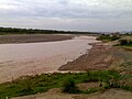
Gallery
[edit]-
 Indus–Sarasvati civilisationmajor sites
 -


See also
[edit]References
[edit]- ^AmbalaOnline - Rivers in Ambala
- ^Chopra, Sanjeev (25 September 2010)."Overflowing Ghaggar, Tangri inundate some villages along Punjab-Haryana border".The Indian Express.Retrieved9 April2017.
- ^ab"HaryanaOnline - Geography of Haryana".Archived fromthe originalon 1 February 2016.Retrieved14 February2018.
- ^abcdValdiya, K.S.(2002).Saraswati: the river that disappeared.Hyderabad: Orient Longman. pp. 23–27.ISBN9788173714030.Retrieved4 May2015.
- ^abcdefgHaryana rivers profile,South Asia Network on Dams, Rivers and People.
- ^Danino, Michel(2010).The lost river: on the trail of the Sarasvatī.New Delhi: Penguin Books India. p. 12.ISBN9780143068648.Retrieved4 May2015.(Chapter 1, page 12)
- ^Rivers in Ambala
- ^Possehl, Gregory L.(December 1997), "The Transformation of the Indus Civilization",Journal of World Prehistory,11(4): 425–472,doi:10.1007/bf02220556,JSTOR25801118,S2CID161129625
- ^Kenoyer, J. M. (1997), "Early City-states in South Asia: Comparing the Harappan Phase and the Early Historic Period", in D. L. Nichols; T. H. Charlton (eds.),The Archaeology of City States: Cross Cultural Approaches,Washington: Smithsonian Institution Press, pp. 52–70,ISBN1560987227
- ^Allchin, Bridget; Allchin, Raymond (1982),The Rise of Civilization in India and Pakistan,Cambridge University Press, p. 160,ISBN978-0-521-28550-6
- ^Erdosy, George, ed. (1995),The Indo-Aryans of Ancient South Asia: Language, Material Culture and Ethnicity,Walter de Gruyter, pp. 44, 266,ISBN978-3-11-014447-5
External links
[edit]- Sarasvati-Sindhu civilization and Sarasvati River
- The Saraswati: Where lies the mystery by Saswati Paik
| Rivers | |
|---|---|
| Lakes |
|
| Dams, barrages | |