Daraina
Daraina | |
|---|---|
 | |
| Coordinates:13°12′S49°40′E/ 13.200°S 49.667°E | |
| Country | |
| Region | Sava |
| District | Vohemar |
| Elevation | 92 m (302 ft) |
| Population (2001)[2] | |
| • Total | 10,000 |
| Time zone | UTC3(EAT) |
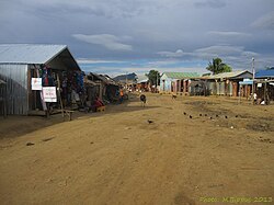
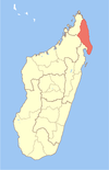
Darainais a town and commune (Malagasy:kaominina) in northernMadagascar.It belongs to thedistrictofVohemar,which is a part ofSava Region.The city is located at the unpaved part of theRoute Nationale 5abetweenVohemarandAmbilobe.
The population of the commune was estimated to be approximately 10,000 in 2001 communecensus.[2]
Primary and junior level secondary education are available in town. The majority 98% of the population of the commune are farmers. The most important crop isrice,while other important products arebanana,maize,cassavaandsweet potato.Services provide employment for 2% of the population.[2]
There are also artisanal gold mining activities on the rivers nearby.
Protected areas
[edit]The protected area ofLoky Manambatois situated at 15km near Daraina. It hosts the only side where theGolden-crowned sifaka(Propithecus tattersalli) can be found.
Geography
[edit]The town is located at theManankolana river.
References and notes
[edit]- ^Estimated based onDEMdata fromShuttle Radar Topography Mission
- ^abc"ILO census data".Cornell University.2002.Retrieved2008-02-25.
13°12′S49°40′E/ 13.200°S 49.667°E


