Denbighshire
This article'slead sectioncontains information that is not included elsewhere in the article.(October 2023) |
Denbighshire
Sir Ddinbych(Welsh) | |
|---|---|
| |
 Denbighshire shown withinWales | |
| Sovereign state | |
| Constituent country | |
| Preserved county | Clwyd |
| Established | 1 April 1996 |
| Administrative HQ | Ruthin |
| Largest town | Rhyl |
| Government | |
| • Type | Principal council |
| • Body | Denbighshire County Council |
| •Executive | No overall control |
| • Leader | Jason McLellan (Welsh Labour) |
| • Chairman | Arwel Roberts |
| • Chief Executive | Graham Boase |
| •MPs | Becky Gittins(L) Gill German(L) |
| Area | |
| • Total | 326 sq mi (844 km2) |
| • Rank | 8th |
| Population (2022) | |
| • Total | 96,558 |
| • Rank | 16th |
| • Density | 300/sq mi (115/km2) |
| Time zone | UTC+0(Greenwich Mean Time) |
| • Summer (DST) | UTC+1(British Summer Time) |
| GSScode | W06000004 |
| ISO 3166-2 | GB-DEN |
| NUTS 3 code | UKL13 |
| ONS code | 00NG |
| Website | denbighshire.gov.uk |

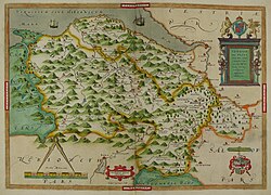
Denbighshire(/ˈdɛnbiʃər,-ʃɪər/DEN-bee-shər, -sheer;[1]Welsh:Sir Ddinbych[ˌsiːrˈðɪnbɨχ]) is acountyin thenorth-eastofWales.It borders theIrish Seato the north,Flintshireto the east,Wrexhamto the southeast,Powysto the south, andGwyneddandConwyto the west.Rhylis the largest town, andRuthinis the administrative centre. Its borders differ from thehistoric county of the same name.
Denbighshire has an area of 326 square miles (840 km2) and a population of 95,800, making it sparsely populated. The most populous area is the coast, where Rhyl and Prestatyn form asingle built-up areawith a population of 46,267. The next-largest towns areDenbigh,Ruthin,andRhuddlan,whileSt Asaphis its only city. All of these settlements are in the northern half of the county; the south is even less densely populated, and the only towns areCorwenandLlangollen.
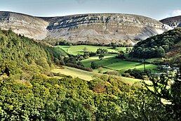
The geography of Denbighshire is defined by the broad valley of theRiver Clwyd,which is surrounded by rolling hills on all sides except the north, where it reaches the coast. TheVale of Clwyd,the lower valley, is given over to crops, while cattle and sheep graze the uplands. TheClwydian Rangein the east is part of theClwydian Range and Dee Valley Area of Outstanding Natural Beauty.

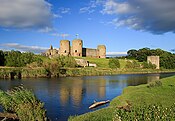
This part of Wales contains the country's oldest known evidence of habitation –Pontnewydd (Bontnewydd-Llanelwy) Palaeolithic sitehasNeanderthalremains of some 225,000 years ago. The county is also home to several medieval castles, includingCastell Dinas Brân,Denbigh,andRhuddlan,as well asSt Asaph Cathedral.Llangollen International Musical Eisteddfodtakes place in the town each July.[2]
Formation
[edit]The main area was formed on 1 April 1996 under theLocal Government (Wales) Act 1994,from various parts of the county ofClwyd.It includes the district ofRhuddlan(formed in 1974 entirely from Flintshire), the communities ofTrefnantandCefn Meiriadogfrom the district ofColwyn(entirely Denbighshire) and most of theGlyndŵrdistrict. The last includes the formerEdeyrnion Rural District,part of the administrative county of Merionethshire before 1974, covering the parishes ofBetws Gwerfil Goch,Corwen,Gwyddelwern,Llangar,Llandrillo yn Edeirnion and Llansanffraid.[3]
Other principal areas including part of historical Denbighshire areConwy,which picked up the remainder of 1974–1996 Colwyn, the Denbighshire parts of 1974–1996Aberconwy,andWrexham,which corresponds to the pre-1974 borough ofWrexhamalong with most ofWrexham Rural Districtand several parishes of Glyndŵr. Post-1996Powysincludes the historically Denbighshire parishes ofLlanrhaeadr-ym-Mochnant,LlansilinandLlangedwyn,which formed part of Glyndŵr district.[3]
Early history
[edit]Researchers have found signs that Denbighshire was inhabited at least 225,000 years ago.Bontnewydd Palaeolithic siteis one of the most significant in Britain. Hominid remains of probableNeanderthalshave been found, along with stone tools from the laterMiddle Pleistocene.[4]
Archaeology
[edit]In 2021 February, archaeologists from Aeon Archaeology announced a discovery of over 300Stone Agetools and artifacts inRhuddlan.They revealedscrapers,microliths,flakes ofchert(a hard, fine-grained, sedimentary rock composed of microcrystalline or cryptocrystalline quartz),flintsand other rudimentary tools. An expert, Richard Cooke, believes the lithic remains belonged to ancient peoples, who while passing through the area, made camp by the river more than 9,000 years ago.[5][6]
Geography
[edit]- See alsoList of places in Denbighshire.
The eastern edge of Denbighshire follows the ridge of theClwydian Range,with a steep escarpment to the west and a high point atMoel Famau(1,820 ft (555 m)),[7]which with the upper Dee Valley forms anArea of Outstanding Natural Beauty,theClwydian Range and Dee Valley–one of just five in the Wales.[8]TheDenbigh Moors(Mynydd Hiraethog) are in the west of the county and theBerwyn Rangeadjacent to the southern edge. TheRiver Clwydhas a broad fertileValerunning from south–north in the centre of the county. There is a narrow coastal plain in the north which much residential and holiday-trade development.[7]The highest point in the historic county wasCadair Berwynat 832 m or 2,730 ft), but the boundary changes since 1974 makeCadair Berwyn North Topthe highest point. Denbighshire borders the present-day principal areas ofGwynedd,Conwy County Borough,Flintshire,Wrexham County Borough,andPowys.
Rhyl and Prestatyn form asingle built-up areain the north of the county, with a population of 46,267. They are immediately adjacent to theKinmel BayandAbergelebuilt-up area in neighbouringConwy,and at the eastern end of series of coastal resorts which that also includesColwyn BayandLlandudnofurther west.
Population
[edit]According to the2021 United Kingdom census,Denbighshire's population was approximately 95,800.[9]According to previous censuses, the population of Denbighshire was 93,734 in 2011 and 93,065 in 2001.[10]The largest towns on the coast areRhyl(2001 population c. 25,000) andPrestatyn(2001 population c. 18,000). According to the 2011 Census returns, 24.6 per cent stated they could speak Welsh.[11]
Economy
[edit]Since the 20th-century demise of the coal and steel industries in theWrexhamarea, there is noheavy industryin the county. Although most towns have smallindustrial parksor estates for light industry, the economy is based on agriculture and tourism. Much of the working population is employed in theservice sector.Theuplandssupport sheep and beef cattle rearing, while in the Vale of Clwyd dairy farming and wheat and barley crops predominate.[12]Many towns have livestock markets and farming supports farm machinery merchants, vets, feed merchants, contractors and other ancillaries.[13]With their incomes on the decline, farmers have found opportunities in tourism, rural crafts, specialist food shops, farmers' markets and value-added food products.[14]
The upland areas with their sheep farms and small, stone-walled fields are attractive to visitors. Redundant farm buildings are often converted into self-catering accommodation, while many farmhouses supply bed and breakfast. The travel trade began with the arrival of the coast railway in the mid-19th century, opening up the area toMerseyside.This led to a boom in seaside guest houses. More recently, caravan sites and holiday villages have thrived and ownership of holiday homes increased.[15]Initiatives to boost the economy ofNorth Walescontinue, including redevelopment of the Rhyl seafront andfunfair.[16]
Transport
[edit]TheNorth Wales Coast Linerunning fromCrewetoHolyheadis served byTransport for WalesandAvanti West Coastservices. Trains leaving Crewe to pass through Chester, cross theRiver Deeinto Wales, and continue throughFlint,Shotton,Holywell Junction(closed in 1966),Prestatyn,Rhyl,and stations toBangorand Holyhead, which has a ferry service to Ireland.[17]
There are no motorways in Denbighshire. TheA55dual carriageway runs from Chester throughSt Asaphto the North Wales coast at Abergele, then parallel to the railway through Conwy and Bangor to Holyhead. TheA548run from Chester to Abergele through Deeside and along the coast, before leaving the coast and terminating atLlanrwst.The main road from London, theA5,passes north-westwards throughLlangollen,CorwenandBetws-y-Coedto join the A55 and terminate at Bangor. TheA543crosses the Denbigh Moors from south-east to north-west, and theA525links Ruthin with St Asaph.[18]
There are local bus services between the main towns. Several services byArriva Buses Walesrun along the main coast road between Chester and Holyhead, linking the coastal resorts. Another route links Rhyl to Denbigh.[19]
Politics
[edit]
Denbighshire was last represented in theHouse of Commonsby threeMPs.TheWelsh Labour Partylost to theWelsh Conservativesin the2019 general electionfor the first time.[20]
The following MPs were elected from Denbighshire in 2019:
- Simon Baynes(Welsh Conservatives) inClwyd South,first elected in2019.[21]
- David Jones(Welsh Conservatives) inClwyd West,first elected in2005.[22]
- James Davies(Welsh Conservatives) inVale of Clwyd,first elected in2019.[23]
From 2024, Denbighshire is covered by four constituencies. These areBangor Aberconwy,Clwyd North,Clwyd EastandDwyfor Meirionnydd.[24]
Denbighshire is also represented in theSeneddby three members elected in 2021:
- Ken Skates(Welsh Labour) inClwyd South,first elected in 2011[25]
- Darren Millar(Welsh Conservatives) inClwyd West,first elected in 2007[26]
- Gareth Davies(Welsh Conservatives) inVale of Clwyd,first elected in 2021.[27]
In 2019, research byUnHerdin association with the pollster FocalData showed that most people across the county support theBritish monarchy.[28]
See also
[edit]- Denbighshire (historic)
- List of Lord Lieutenants of Denbighshire
- List of Custodes Rotulorum of Denbighshire
- List of High Sheriffs of Denbighshire
- Denbighshire (UK Parliament constituency)
- List of places in Denbighshire
- List of schools in Denbighshire
References
[edit]- ^Jones, Daniel(2011).Roach, Peter;Setter, Jane;Esling, John(eds.).Cambridge English Pronouncing Dictionary(18th ed.). Cambridge University Press.ISBN978-0-521-15255-6.
- ^"Attractions in Clwyd".Britain Express.Retrieved21 April2016.
- ^ab"Local Government (Wales) Act 1994".The National Archives.legislation,gov.uk.Retrieved1 May2016.
- ^"Pontnewydd Cave".University of Central Lancashire. Archived fromthe originalon 7 May 2016.Retrieved1 May2016.
- ^"Hundreds of stone age tools found on Denbighshire housing site".BBC News. 17 February 2021.Retrieved15 June2021.
- ^"Encampment dating back 9,000 years has been discovered in Rhuddlan".Denbighshire Free Press.17 February 2021.Retrieved15 June2021.
- ^abPhilip's (1994).Modern School Atlas.George Philip & Son. p. 26.ISBN0-540-05278-7.
- ^"Clwydian Range".North East Wales. Archived fromthe originalon 19 April 2014.Retrieved30 April2016.
- ^Evans, Harri (28 June 2022)."The population of North Wales has dropped in the last decade".North Wales Live.Retrieved3 December2022.
- ^"Local Authority population 2011".Archived fromthe originalon 22 May 2015.Retrieved22 May2015.
- ^"Welsh speakers by local authority, gender and detailed age groups, 2011 Census".Stat Wales.Archived fromthe originalon 9 May 2016.Retrieved1 May2016.
- ^"Clwyd".NFU Cymru. 5 December 2014. Archived fromthe originalon 20 March 2016.Retrieved1 May2016.
- ^Morris, Jan (2014).Wales: Epic Views of a Small Country.Penguin Books Limited. p. 234.ISBN978-0-241-97024-9.
- ^Nienaber, Birte (2016).Globalization and Europe's Rural Regions.Routledge. pp. 76–83.ISBN978-1-317-12709-3.
- ^Boniface, Brian G.; Cooper, Chris; Cooper, Robyn (2012).Worldwide Destinations: The Geography of Travel and Tourism.Routledge. pp. 129, 152–153.ISBN978-0-08-097040-0.
- ^"Six projects to kick-start the North Wales economy in 2016".Daily Post.1 January 2016.Retrieved1 May2016.
- ^"Crewe to Holyhead".North Wales Coast Railway. 2012.Retrieved30 April2016.
- ^Concise Road Atlas: Britain.AA Publishing. 2015. pp. 47–55.ISBN978-0-7495-7743-8.
- ^"Discover the towns of Wales".Arriva Wales.Arriva Buses Wales.Retrieved30 April2016.
- ^"General Election 2019: Tories win overall majority as Labour suffer in North Wales".Denbighshire Free Press.12 December 2019.Retrieved14 December2019.
- ^"Clwyd South parliamentary constituency – Election 2019".Retrieved14 December2019.
- ^"Clwyd West parliamentary constituency – Election 2019".Retrieved14 December2019.
- ^"Vale of Clwyd parliamentary constituency – Election 2019".Retrieved14 December2019.
- ^"2023 Parliamentary Review - Revised Proposals | Boundary Commission for Wales".Boundary Commission for Wales.Retrieved20 June2023.
- ^"Clwyd South – Welsh Assembly constituency – Election 2016".Retrieved14 December2019.
- ^"Clwyd West – Welsh Assembly constituency – Election 2016".Retrieved14 December2019.
- ^"Vale of Clwyd – Welsh Assembly constituency – Election 2021".Retrieved26 May2021.
- ^"People in Denbighshire still back the monarchy".Denbighshire Free Press.29 November 2019.Retrieved14 December2019.
External links
[edit]- .Encyclopædia Britannica.Vol. 8 (11th ed.). 1911. p. 18.
- DenbighshireatCurlie
- Denbighshire landscape


