
Deventer
Deventer
Daeventer(Sallands) | |
|---|---|
 Flag  Coat of arms | |
 Location in Overijssel | |
 Deventer Location within the Netherlands  Deventer Location within Europe | |
| Coordinates:52°15′N6°9′E/ 52.250°N 6.150°E | |
| Country | Netherlands |
| Province | Overijssel |
| Government | |
| • Body | Municipal council |
| •Mayor | Ron König (D66) |
| Area | |
| • Total | 134.33 km2(51.87 sq mi) |
| • Land | 130.68 km2(50.46 sq mi) |
| • Water | 3.65 km2(1.41 sq mi) |
| Elevation | 9 m (30 ft) |
| Population (January 2021)[3] | |
| • Total | 101,236 |
| • Density | 775/km2(2,010/sq mi) |
| Demonym | Deventernaren |
| Time zone | UTC+1(CET) |
| • Summer (DST) | UTC+2(CEST) |
| Postcode | 7400–7438 |
| Area code | 0570 |
| Website | www |


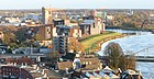
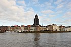
Deventer(Dutch:[ˈdeːvəntər];Sallands:Daeventer) is acityandmunicipalityin theSallandhistorical region of theprovinceofOverijssel,Netherlands. In 2020 the municipality of Deventer had a population of 100,913. The city is largely situated on the east bank of the riverIJssel,but it also has a small part of its territory on the west bank. In 2005 the municipality ofBathmen(with a population of about 5,000 people) was merged with Deventer as part of a national effort to reducebureaucracyin the country.
Deventer is one of the oldest cities in the Netherlands.[4]The place is mentioned in 9th-century sources from theDiocese of Utrecht.A charter from 877 AD mentions seven farmsteads inDaventre portu[5](the Deventer harbor). In 952 AD, Deventer is mentioned as a city in a gift certificate fromKing Otto I.[6]After the place had acquired more and more rights and privileges over time, it received the municipal lands fromEmperor Henry Vin 1123. This is considered by historians to be the moment of Deventer obtaining the city rights by the inhabitants.[7]The city has the oldest stone house, the oldest walking park and with the Athenaeum library also the oldest scientific library in the Netherlands.
History
[edit]Foundation and development in the Middle Ages
[edit]Deventer was probably founded around 768 AD by theEnglishmissionaryLebuinus,who built a wooden church on the east bank of the riverIJssel.In January 772 AD the sack and burning of this church by a Saxon expedition was the cause for the first punitive war waged by Charlemagne to the Saxons, in which, in retribution, theIrminsul(the Saxon sacred tree, probably near modernPaderborn) was destroyed. This was not the first human settlement at the location; between 1981 and 2006, remains of a lateRoman Iron Agesettlement (dated to c.300 AD) were excavated at Colmschate, 4 km east of the current city

The village of Deventer, already important because of a trading road crossing the riverIJssel,was looted and burnt down by theVikingsin 882. It was immediately rebuilt and fortified with an earthen wall (in the streetStenen Walremains of this wall have been excavated and restored).
Deventer receivedcity rightsin 956, after which fortifications were built or replaced by stone walls around the city for defense. Between 1000 and 1500, Deventer grew to be a flourishing trade city because of its harbour on the river IJssel, which was capable of accommodating large ships. The city eventually joined theHanseatic League.
One of the commodities it traded in, dried haddock and cod from Norway, gave the citizens the nickname they carry to this day: "DeventerStokvis".In the 15th century, Deventer had a common mint, where coins for the three IJssel cities Deventer,Zwolle,andKampenwere made.
Deventer is the birthplace ofGeert Grooteand home to hisBrethren of the Common Life,a school of religious thought that influencedThomas a KempisandErasmusin later times. Together with Haarlem it was among the first cities to have printing presses, dating back to as early as 1477. From around 1300, it also housed a Latin School, which became internationally renowned, and remained in service in changing forms until 1971. Its most well-known student was the scholarDesiderius Erasmus,who was born in 1466 and attended the school from 1475 to 1484.
16th–18th centuries
[edit]


Between 1500 and 1800, the volume of water flowing through the IJssel decreased, decreasing the importance of Deventer's harbour. The competition with trade centres inHolland,as well as thereligious warbetween 1568 and 1648, brought a decline in the city's economy.
In the 18th century, theironindustry came to Deventer. East of the town, so-called "oer", riversand containing iron, was found as early as 900. From this material, ore was produced and brought to town. The main road of the villages Okkenbroek, Lettele and Schalkhaar is still named Oerdijk (Ore Dyke).
Modern times
[edit]
In the 19th century, Deventer became an industrial town. Bicycles (Burgers), carpets (Koninklijke Deventer Tapijtfabriek), tins and cans for food and drinks (Thomassen & Drijver), cigars (Horst & Maas en Bijdendijk & Ten Hove), foundry and heavy machinery (Nering Bögel), and textiles (Ankersmit)[8]were produced until the mid to late 20th century. Some of these industries are still thriving today, such as beds and accessories (Auping) and publishing (Wolters Kluwer,now headquartered inAlphen aan den Rijn).
The city's trade and industry are still of some importance. The city is host to a factory producingcentral heatingsystems, as well asWolters Kluwer,a global information services and publishing company.
The Deventer honey cake (Bussink Deventer Koek), produced in Deventer for over 500 years, is still manufactured locally and sold all over the Netherlands and beyond.
World War II
[edit]
Deventer has seen few military engagements throughout its long history, although it was agarrisoncity of the Dutchcavalry.The IJssel bridge area and harbour were bombed heavily duringWorld War II.The city centre has been largely spared, but many Allied bombs, meant to shell the IJssel railway bridge, came down on buildings in the city centre. The Deventer railway bridge was considered strategically important, being a part of the main railway connection between Amsterdam and the German city of Osnabrück, leading from there to either Berlin, Hamburg or Bremen. The railway bridge, constructed of steel, was difficult to hit. Many bombs were bounced down into the river or its banks, exploding in the areas around the bridge or failing to explode at all. The three heaviest of about 15 attacks were on October 28, 1944 causing 35 fatalities; on December 15, 1944 killing 33 people; and on February 6, 1945 causing the death of 61 people. In the aftermath of this last bombardment, the German occupying forces committed awar crime.The German army used acool warehousein Deventer for its military food supplies. In the city centre, theretirement homeof theUnited Foundations,originally dating back as far as the 13th century, caught fire by the shellings, as well as the army food warehouse. The Germans allowed local fire fighters only to extinguish the fire in the cool warehouse. The retirement home burnt down as good as totally. Over twenty of the elderly living there perished in the flames.[9]
The Jewish poet and writerEtty Hillesumlived in Deventer during the war before being deported toAuschwitz.
In Schalkhaar, a village only 2 km northeast of the city centre, barracks were used by the German occupying forces to train Nazi policemen. The compound is now a centre forasylum seekers.
In a forested area between Lettele and Okkenbroek, about 10 kilometres east of Deventer, the Germans operated aV-1 flying bomblaunching ramp. It was used from December, 1944, until March, 1945. Some of the 400 V-1 missiles launched there hit already liberated Belgium, including the city of Antwerp, killing many people. A war monument in the village of Lettele consists of concrete blocks from this launching site, that is a war monument itself as well.[10]
Deventer has been somewhat popular with the film industry. During the production of the 1977 filmA Bridge Too Far,all of the scenes taking place in nearbyArnhemwere filmed in Deventer - as Arnhem itself had lost its historic centre.
By the end of the 1950s, the buildings had reached the boundaries of the municipality. In 1960, for further expansion, the part of the municipality of Diepenveen was annexed that now covers the Keizerslanden, Borgele and Platvoet districts, all three realized in the 1960s; all together roughly the area up to (west of) the Zandwetering.
After a plan to expand the city across the IJssel, the so-called Double City Plan, was deemed unfeasible at the end of the 1960s, Deventer turned its attention to the east again: in 1974 part of Diepenveen was once again annexed. On January 1, 1999, the municipality of Diepenveen was dissolved and added to Deventer. The same happened with the municipality of Bathmen on 1 January 2005.
Demographics
[edit]Deventer has 101.378 Inhabitants on 1 July 2021.
Inhabitants by nationality
[edit]- 77.37% is Dutch
- 9.23% western migration background
- 13.4% non western migration background
Geography
[edit]
Associated hamlets at second level


The population centres in the municipality are:
- Deventer(see below)
- Snippeling(a small community about 2 km east of the city centre)
- De Worp, the quarter west of the IJssel river
- Colmschate(Deventer suburb quarters surrounding eponymous village 4 km east of the city centre, ice skating hall, small railway station)
- De Bannink
- Oxe
- Diepenveen,a village 4 km to the north, surrounded by forest
- Molenbelt
- Rande
- Tjoene
- Lettele,in a forest area
- Linde
- Oude Molen (old mill)
- Zandbelt
- Okkenbroek
- Schalkhaar(former centre of Diepenveen municipality including Lettele and Okkenbroek until 1999)
- Averlo
- Frieswijk
- Bathmen(independent municipality until 2005)
- Apenhuizen
- Dortherhoek
- Loo
- Pieriksmars
- Zuidloo
Climate
[edit]Deventer is in thenorthern hemisphere.Summer here starts at the end of June and ends in September. Deventer experiences anoceanic climate(Köppen climate classificationCfb) similar to almost all of theNetherlands.
| Climate data for Deventer | |||||||||||||
|---|---|---|---|---|---|---|---|---|---|---|---|---|---|
| Month | Jan | Feb | Mar | Apr | May | Jun | Jul | Aug | Sep | Oct | Nov | Dec | Year |
| Mean daily maximum °C (°F) | 5.3 (41.5) |
6.3 (43.3) |
9.6 (49.3) |
14.1 (57.4) |
17.8 (64.0) |
20.5 (68.9) |
22.4 (72.3) |
21.8 (71.2) |
18.8 (65.8) |
14.3 (57.7) |
9.3 (48.7) |
6.0 (42.8) |
13.8 (56.8) |
| Daily mean °C (°F) | 3.1 (37.6) |
3.3 (37.9) |
5.8 (42.4) |
9.7 (49.5) |
13.6 (56.5) |
16.4 (61.5) |
18.4 (65.1) |
17.9 (64.2) |
15.1 (59.2) |
11.2 (52.2) |
7.0 (44.6) |
3.9 (39.0) |
10.4 (50.7) |
| Mean daily minimum °C (°F) | 0.9 (33.6) |
0.7 (33.3) |
2.2 (36.0) |
5.2 (41.4) |
9.0 (48.2) |
11.9 (53.4) |
14.2 (57.6) |
13.9 (57.0) |
11.6 (52.9) |
8.4 (47.1) |
4.7 (40.5) |
1.8 (35.2) |
7.0 (44.6) |
| Averageprecipitationmm (inches) | 71.0 (2.80) |
58.0 (2.28) |
60.0 (2.36) |
55 (2.2) |
67.0 (2.64) |
74.0 (2.91) |
86.0 (3.39) |
83.0 (3.27) |
70.0 (2.76) |
66.0 (2.60) |
66.0 (2.60) |
74.0 (2.91) |
830.0 (32.68) |
| Mean monthlysunshine hours | 72.0 | 96.0 | 127.2 | 189.6 | 216.0 | 228.0 | 235.2 | 208.8 | 165.6 | 124.8 | 86.4 | 69.6 | 1,819.2 |
| Source: Climate-Data.org[11] | |||||||||||||
Water
[edit]
The Deventer settlement was founded on a river dune on theIJssel.This river has played a major role for the city over the centuries, because of the trade that this waterway brought with it. In 1241 the city had received the Katentol on long lease from the Elten stift. This toll, which is named after the Katerveer underZwolle,had to be paid in the Deventer toll house near the Zandpoort, and generated a lot of money in theMiddle Ages.
The IJssel has also caused many problems over the centuries, because it often overflowed its banks. Nowadays Deventer has a flood defence, but the Welle ('wal', the name of the street over the quay) is still regularly under water during high water. Dike breaches of the IJssel have created many gullies in and around the city, such as the Douwelerkolk and the Klinkenbeltskolk.
In addition to the IJssel, Deventer has a large number of waters. TheSchipbeekis a brook partly dug on behalf of the city that rises inGermanyand flows into the IJssel near Deventer. In the past, the stream was navigable, so that wood and Bentheimer sandstone could be brought in, among other things. Another waterway that was built for shipping and which flows into the IJssel in Deventer is a branch of the Overijssels canal, through which Deventer was connected to a large system of canals through Overijssel. It was dug in the mid-19th century and opened in 1858.
Culture
[edit]Sights
[edit]
- The Grote Kerkhof square (Grand Churchyard).
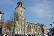
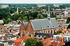
- The SaintLebuïnuskerk(St. Lebuin's Church) inGothic style,with ceiling paintings and an organ. Its tower can be climbed in summer.
- The City Hall with a façade built in 1693 inDutch Baroque style.
- The Brink (market square) with houses, shops, and cafes dating from 1575 to 1900. The market square is also the centre of Deventer nightlife. Alongside this square there is the Bussink "Koekhuisje", where the honey-cake Deventer Koek is sold. Markets take place every Friday (including one on Good Friday, following a medieval tradition) and Saturday.
- The Waag (Weighing-house) on the edge of the Brink square, built in 1550 and restored in 2003. The Deventer City Museum is housed inside the Waag. The Museum's collections include industrial and trading history, paintings byGerard TerborchandHan van Meegeren,silver objects, and prehistoric findings).Thea Beckman's novelHet wonder van Frieswijck( "The Frieswijck Miracle" ) features the Waag.
- On the outer wall of the Waag hung until 2016 a large kettle that is over 500 years old, said to have been used for apublic executionin the lateMiddle Ages;a man who had produced counterfeit coins was cooked to death in it. According to local tradition, there are holes in the kettle shot by footmen ofNapoleon's army around 1809. In 2017 the kettle has been placed inside the building, at the entrance of the museum.
- The Speelgoedmuseum (ToyMuseum) behind the Waag, housed in an old house in the city calledDe Drie Haringen('The Three Herrings').
- TheGreat Synagogue of DeventerinNeo-Renaissance stylewithMoorishinfluences.
- The medievalBergkerk(Mountain Church), on top of a small hill (old river dune), now a place for expositions and concerts.
- The old streets around the Bergkerk, known as Bergkwartier (Mountain Quarter) situated on and around the old river dune.
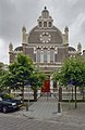
- The Broederenkerk (Friars church) in Gothic and neo-Gothic style
- The Stadsarchief en Athenaeumbibliotheek (City Archive and Athenaeum Library), the oldest scientific library of the Netherlands (founded in 1560).
- De Proosdij in the Sandrasteeg is the oldest stone house of the Netherlands still in use. The earliest parts dating back to around 1130.
-
-
 Deventer City Hall
 -
-

-
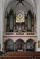 Interior of Broederenkerk
 -
 City Archives and Athenaeum Library
 -
 Theater of Deventer
 -
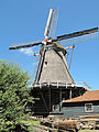
 The 19th-century Bolwerksmolen


Sports
[edit]
Deventer is the home of professional Football clubGo Ahead Eagles,who are housed in stadiumDe Adelaarshorst.De Adelaarshorst is situated in a 1930s neighbourhood and one of the oldest stadiums still in use today.[citation needed]The club was founded in 1902 as Be Quick, although the name was soon changed to Go Ahead at the request of theDutch Football Association.The suffix Eagles was added in 1971, following a suggestion from the then coach,Barry Hughes.Go Ahead Eagles has been the club ofMarc Overmars,Paul Bosvelt,andBert van Marwijk,whilst providingHenk ten CateandLeo Beenhakkerwith their first experience of management.
The 1992 founded skating rink De Scheg, which is semi-indoor since 2011, is in the top 10 of fastest skating tracks of the Netherlands.[citation needed]It has been the training accommodation of skaters including Olympic championMark Tuitertand the retired former world champion sprintErben Wennemars.
Deventer also houses a number of watersports clubs, due to its situation on the banks of the river IJssel.
Events and festivals
[edit]- In the first weekend of July, the city centre is the scene of the open air festival "Deventer op stelten" (Deventer onStilts). Actors and artists give performances in the streets and on the Brink square. Originally all actors used stilts during their acts.
- In August, Deventer is home to Europe's largest book fair, attracting 125,000 visitors.[12]
- TheDickensFestival in December sees some of the oldest streets and alleys in the city dressed up in the style of theVictorian era.In 2018, the festival attracted 125,000 visitors.[13]
Government
[edit]City council
[edit]
In the redivision elections of November 17, 2004, amunicipal executivewas elected for the period 2005-2010. This municipal election was earlier than in the rest of the Netherlands, because the municipality of Deventer was merged with the then municipality of Bathmen. The March 2006 elections were therefore skipped.
An issue that has occupied the municipal council and public opinion in Deventer since 2006 was the housing of municipal officials and public services in a (new) municipal office adjacent to the old town hall of Deventer. In 2009, the college fell over it. At the end of January 2012, the Municipal Executive approved an adapted design for the new city office by architectMichiel Riedijk.However, a 'popular poll' by telephone two weeks later would have shown that only 13% of the population of Deventer supported the plans. On March 21 that year, a large majority of the city council voted in favor of the municipal office. In October 2013, the Council of State ruledpositive about the arrival of the municipal office, after objections were raised. On December 6 of that year, the official opening act for construction was performed. In December 2015, the complex was completed and municipal staff moved in. In November 2017, the architect received the Abe Bonnema Prize for the design.
Economy
[edit]This sectionneeds expansion.You can help byadding to it.(February 2023) |
Business
[edit]- Girasolar,founded in 2003
Education
[edit]
Deventer is also home to one of the three campuses ofSaxion University of Applied Sciences(Saxion Hogeschool), apolytechnical schooloffering internationally recognizedBachelor's degreesandMaster's degreesin a wide range of fields, including engineering, economics, social work, investigations and health care.[14]The other campuses are located inEnschedeandApeldoorn.
In 1912 theSecondary Colonial Agricultural Schoolwas founded, which grew out of the National Agricultural School Wageningen. After decolonization took effect, the name was changed into Tropical Agricultural School. In 1957 the school was transformed into the National Higher School for Tropical Agriculture. After a merger with study programs from Boskoop, Wageningen and Velp, it became the International Agricultural College Larenstein. The school was located at the Ceintuurbaan/Brinkgreverweg intersection. The building was given a residential destination in 2018.
Transport
[edit]Rail
[edit]
Since 1989, Deventer has two train stations,Deventer railway stationandDeventer Colmschate station.Previously, Deventer has known several so-called stopping points. Most of them closed around 1920. In addition to the current rail connections from Deventer train station, over theArnhem–Leeuwarden railway,Apeldoorn–Deventer railway,andDeventer–Almelo railwaylines, a train connection existed from 1910 to 1935 on theDeventer–Ommen railwayline. This was operated by the Overijsselsche Lokaalspoorweg-Maatschappij Deventer - Ommen (OLDO), but had to stop the train service due to competition from the bus.
Public transport
[edit]
In the 19th and 20th centuries, Deventer was connected to the extensive tram network of theAchterhoek.The tram line between Deventer andBorculowas operated from 1885 to 1944 by the Geldersch-Overijsselsche Stoomtram Maatschappij (GOSM) and its successors. Another tram company, theTramweg Maatschappij Zutphen-Emmerik,operated the tram line between Deventer and Zutphen. The tram station of Deventer stood on the Pothoofd. It was not combined with Deventer train station because the trams were too heavy to drive over two intermediate bridges. It seemed unprofitable for the tram company to reinforce two bridges, so they used the Pothoofd as a terminal station. After theSecond World War,the tram lines were dismantled.
Since the end of 2020, bus transport has been provided byKeolis Nederlandunder the nameRRReis,with the exception of the lines from the Achterhoek, which are provided byArriva.
Notable residents
[edit]
Public thinking & public service
[edit]
- Lebuinus(??-ca.775) the Apostle of theFrisiansand patron of Deventer
- Saint Radboud(before 850 – 917)Bishop of Utrecht899 to 917
- Geert Groote(1340–1384) a Dutch Roman Catholic deacon, founder of theBrethren of the Common Life[15]
- Gerlac Peterssen(ca.1377 – 1411) a Dutch mystic[16]
- Alexander Hegius von Heek(ca.1435–1498) a German humanist who settled in Deventer[17]
- Jacobus Revius(1586–1658) a Dutch poet, Calvinist theologian and church historian
- Samuel Holland(1728–1801) aRoyal Engineerand Surveyor General ofBritish North America
- Abraham Josias Sluysken(1736-1799) last Governor of theDutch Cape Colony
- Rutger Jan Schimmelpenninck(1761–1825) a Dutch jurist, ambassador, politician andGrand Pensionaryof theBatavian Republic
- Frans Adam van der Duyn van Maasdam(1771-1848)nobleman,officer and politician
- Louis Gerlach Pareau(1800–1866) a theologian and academic, co-foundedGroningen theology
- Willem Jan Knoop(1811–1894) a Dutch lieutenant-general, military historian, and politician
- W. R. van Hoëvell(1812–1879) a minister in theDutch East Indies,politician and reformer
- Elisabeth van Dedem Lecky(1842–1912) a Dutch-Irish writer, historian and suffragist
- Martinus Theunis Steyn(1857–1916) a South African lawyer, politician and statesman[18]
- Han Hollander(1886–1943) the first Dutch radio sports journalist
- Etty Hillesum(1914–1943) wrote about the persecutions of the Jews during theGerman occupation
- Bé Udink(1926–2016) a Dutch politician, government minister, diplomat and businessman
- Willem Scholten(1927–2005) a Dutch politician, government minister and economist
- Jomanda(born 1948) a controversial Dutch healing medium
- Guusje Ter Horst(born 1952) a retired Dutch politician and psychologist
- Caroline van der Plasleader of the BBB political party and member of the house of Netherlands representatives since 2021.
The arts
[edit]
- Jan Pieterszoon Sweelinck(1562–1621) a Dutch composer, organist andpedagogue
- Bartholomeus Breenbergh(1598–1657) aDutch Golden Agepainter ofItalianatelandscapes
- Gerard Ter Borch(1617–1681) aDutch Golden Agegenre painter
- Justus Hiddes Halbertsma(1789–1869) a Frisian writer, poet, minister and linguist
- Han van Meegeren(1889–1947) a Dutch painter, portraitist and art forger
- Truus Schröder-Schräder(1889–1985) a Dutch socialite, involved withavant-gardeartists and architects of theDe Stijlmovement, lived in theRietveld Schröder House
- Mannus Franken(1899–1953) a Dutch filmmaker, developed theIndonesian cinema[19]
- Jan Kleinbussink(born 1946) a classical musician, cantor-organist of the Lebuïnus Church
- Pieter Jan Brugge(born 1955) a Dutch film producer[20]
- Rob Voerman(born 1966) a Dutch graphic artist, sculptor and installation artist
- Clara Wildschut(1906-1950), a Dutch composer
Science & business
[edit]
- Jacob van Deventer(ca. 1500 in Kampen – 1575) a Dutch cartographer of theRenaissance
- John GroenveldtM.D. (ca.1647-ca.1710) a physician, member of theRoyal College of Physicians[21]
- Willem ten Rhijne(1647–1700) a doctor and botanist with theDutch East India Company
- Hendrik van DeventerM.D. (1651–1724), considered the world's foremost obstetrician and gynaecologist at the time
- Johannes C. H. de Meijere(1866–1947) a Dutch zoologist andentomologist
- Lourens Baas Becking(1895–1963) a Dutch botanist andmicrobiologist
- David de Wied(1925–2004) a Dutch professor ofpharmacologyat theUniversity of Utrecht
- Hubert Schoemaker(1950–2006) a Dutchbiotechnologist
Sport
[edit]

- Gerard le Heux(1885–1973) a horse rider, team bronze medallist at the1928 Summer Olympics
- Jan Bultman(born 1942) a former water polo player, competed at the1964 Summer Olympics
- Dick Schneider(born 1948) a retired Dutch footballer with over 500 club appearances
- Bert van Marwijk(born 1952) a Dutch former footballer with 468 club appearances and current manager
- Jan van Dijk(born 1956) a footballer with 465 club appearances withFC Groningenand current manager
- René Temmink(born 1960) a Dutch former football referee
- Gertjan Verbeek(born 1962) a Dutch former footballer with 285 club appearances and current manager
- Ron Dekker(born 1966) a breaststroke swimmer, competed at the1988 Summer Olympics
- Jan Michels(born 1970) a Dutch footballer with over 400 club appearances
- Marc Overmars(born 1973) footballer with 399 club appearances, director of football atAFC Ajax
- Victor Sikora(born 1978) a Dutch football player with 330 club appearances
- Marloes Coenen(born 1981 in Olst) a retired Dutch mixed martial artist
- Boaz Meylink(born 1984) a Dutch rower, team bronze medallist at the2016 Summer Olympics
- Bas Dost(born 1989) a Dutch professional footballer with over 300 club appearances
- Carlijn Achtereekte(born 1990) a long-distance speed skater, gold medallist at the2018 Winter Olympics
- Elis Ligtlee(born 1994) a Dutch track cyclist, gold medallist at the2016 Summer Olympics
International relations
[edit]Deventer istwinnedwith four cities:
|
Gallery
[edit]-
 Tower of theSt. Lebuinus Church
 -
 De Brink panorama
 -
 Aerial view of Broederenkerk
 -

-
 Pothoofd panorama
 -
 Panorama of Deventer city centre
 -
 View ofSt. Lebuinus Churchfrom the river
 -
 Bolwerksmolen windmill
 -
 IJssel near Deventer, Wellekade
 -
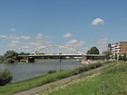 De Wilhelminabrug bridge


References
[edit]- ^"Kerncijfers wijken en buurten 2020"[Key figures for neighbourhoods 2020].StatLine(in Dutch).CBS.24 July 2020.Retrieved19 September2020.
- ^"Postcodetool for 7411KT".Actueel Hoogtebestand Nederland(in Dutch). Het Waterschapshuis.Retrieved27 March2014.
- ^"Bevolkingsontwikkeling; regio per maand"[Population growth; regions per month].CBS Statline(in Dutch).CBS.1 January 2021.Retrieved2 January2022.
- ^"Diverse overzichten van de stadsrechten in Nederland".2015-10-16. Archived fromthe originalon 2015-10-16.Retrieved2021-10-22.
- ^Otten, Dirk (2006).Lebuïnus, een gedreven missionaris(in Dutch). Uitgeverij Verloren.ISBN978-90-6550-914-7.
- ^Koch, A.C.F.; Kruisheer, Jaap (1992).Sammlung(in Dutch). Uitgeverij Verloren.ISBN978-90-6550-245-2.
- ^"Deventer".mijn.land.Retrieved2021-10-22.
- ^Archived atGhostarchiveand theWayback Machine:"OPGEDOEKT, documentaire over Ankersmit Deventer".YouTube.
- ^Source:Klakkende laarzen aan de IJssel (...)by K.H. Vos, 1995, Arko Editors, ISBN 90-72047-26-5 (in Dutch), pp. 71-82, 93
- ^"V1 Feuerstellung 519 Lettele - Lettele - TracesOfWar.nl".
- ^"Climate Deventer (The Netherlands)".RetrievedOctober 22,2021.
- ^"Algemene informatie".deventerboekenmarkt.nl.Archived fromthe originalon 2019-02-14.Retrieved2019-03-09.
- ^"Dickens Festijn weer goed voor 125.000 bezoekers".destentor.nl.Retrieved2019-03-09.
- ^Saxion."Get Ready for a Smart World | Saxion University of Applied Sciences | Saxion".Hogeschool Saxion.Retrieved2021-10-23.
- ^.Encyclopædia Britannica.Vol. 12 (11th ed.). 1911.
- ^.Catholic Encyclopedia.Vol. 11. 1911.
- ^.Encyclopædia Britannica.Vol. 13 (11th ed.). 1911.
- ^.Encyclopædia Britannica.Vol. 25 (11th ed.). 1911.
- ^IMDb Databaseretrieved 23 February 2020
- ^IMDb Databaseretrieved 21 February 2020
- ^.Dictionary of National Biography.Vol. 23. 1890.
- ^ab"Twin Cities of Tartu".©2007 City of Tartu.Retrieved2009-01-04.
- ^"Working visit and celebration 25 years partnership Sibiu-Deventer".2015.Retrieved3 Jan2020.
External links
[edit]- .Encyclopædia Britannica.Vol. 08 (11th ed.). 1911.
- Official website
- Official Tourist websiteArchived2008-04-12 at theWayback Machine
Places adjacent to Deventer | ||||||||||||||||
|---|---|---|---|---|---|---|---|---|---|---|---|---|---|---|---|---|
| ||||||||||||||||
Members of theHanseatic Leagueby quarter, and trading posts of the Hanseatic League | ||||
|---|---|---|---|---|
| ||||
| Wendish |
|   | ||
| Saxon | ||||
| Baltic | ||||
| Westphalian | ||||
| Kontore | ||||
| Vitten | ||||
| Factories | ||||
Overijsselprovince | ||
|---|---|---|
| Municipalities |  | |
| Regions | ||
| International | |
|---|---|
| National | |
| Geographic | |
| Other | |