
Dharmatala
Dharmotala | |
|---|---|
Neighbourhood in Kolkata (Calcutta) | |
 Bentinck Street in Dharmatala | |
 Location of Dharmatala in Kolkata | |
| Coordinates:22°33′36″N88°21′09″E/ 22.560055°N 88.352540°E | |
| Country | |
| State | West Bengal |
| District | Kolkata |
| City | Kolkata |
| Metro Station | Chandni ChowkandEsplanade |
| Municipal Corporation | Kolkata Municipal Corporation |
| KMCwards | 46,47 |
| Elevation | 36 ft (11 m) |
| Population | |
| • Total | For population see linked KMC ward pages |
| Time zone | UTC+5:30(IST) |
| PIN | 700013, 700069 |
| Area code | +91 33 |
| Lok Sabhaconstituency | Kolkata Uttar |
| Vidhan Sabhaconstituency | Chowranghee |
Dharmatala(archaic spellingDhurrumtollah[1]) is a neighbourhood ofCentral Kolkata,inKolkata districtin theIndianstateofWest Bengal.Dharmatala Street has been renamed afterLeninas Lenin Sarani but the neighbourhood up to Wellington Square continues to be referred as Dharmatala. It is a busy commercial area that had come up with the growth of Calcutta during theBritish Rajand is thus one of the repositories of history in the city.
Etymology
[edit]Dharmatala means Holy Street. It is commonly held to derive its name from a large mosque which stood at the site of Cook and Company's livery stables. Some discern the name as a reference todharma,one of the units of theBuddhist Trinity.There was a Buddhist temple atJanbazar,nearby.Tipu Sultan Mosqueat the corner ofChowringhee Roadand Dharmatala, was built in 1842, byPrince Gholam Mohammad,son ofTipu Sultan.[2]Binoy Ghoshfeels that the name Dharmatala is because of the preeminence ofDharmathakurin olden days.HarisandDoms,who are worshippers of Dharmathakur, predominated the area even in the memorable past.[3]
Geography
[edit]
Dharmatala extends fromChowringhee Road(renamed Jawaharlal Nehru Road) to Nirmal Chandra Street. It is bounded to the north byBowbazar,the south byJanbazar,the east byTaltalaand the west byMaidan.[2]
The neighbourhood is spread over 2 wards: 46 and 47 ofKolkata Municipal Corporation.[4]
History
[edit]In the 18th century, Dharmatala is described as ‘a well raised causeway, raised by deepening the ditch on both sides’. It was shaded with trees on both sides.[2]
Just north of Dharmatala a creek formerly ran from Chandpal Ghat toBeliaghata(or Baliaghata, as it was then known). The creek passed through what was later Wellington Square (renamed Subodh Chandra Mallick Square) and Creek Row. The earlier name of Creek Row was Dhinga Bhanga, as a ship broke there during the cyclone of 1737. The creek was navigable for large boats. Wellington Square was a tank made on the bed of this creek. Both Wellington Square and Creek Row were developed by the Lottery Committee. Calcutta Gazette of 9 August 1821 refers to Wellington Square as ‘the new square in Dhurrumtollah.’[2]
While the English quarter was then restricted to around the old fort (presentB.B.D. Bagh), the area south of Dharmatala was a jungle. The native quarters to the north consisted of a number of straggling villages.[5]
After their victory in theBattle of Plassey,the English decided to build newFort William,in 1758. For this purpose, the native population shifted fromGobindapurmostly toSutanuti.The European inhabitants ofKalikatagradually forsook the narrow limits of the old palisades and moved to around theMaidan.[6]Civilians were not allowed to live within the new fort. Gradually the areas to the south of theGreat Tankand to the east alongChowringhee Roadwere emerging as preferred haunts for the Englishmen. While Sutanuti developed as the Black Town, theEsplanadeandChowringheeemerged as the White Town. However, the areas aroundWriters' building,Baitakkhana(Bowbazar), Dharmatala andJanbazarwent down in estimation and were gradually taken over by ‘the rest’, which included half-castes,Portuguese,Armeniansand so on, 'to become grey areas between Black and White Towns of old Calcutta'.[7]
The district lying between Dharmatala and Bowbazar and bounded on the west by Bentinck Street was in the 19th and 20th century inhabited by a variety of people that included Portuguese, other Europeans of poorer classes and Indians. The area was full of ‘tortuous and narrow lanes, badly drained and reeking with foul odours, thickly populated and miserably housed.’ In this district on the northern side of Dharmatala is a bazaar called Chandney Chowk. ‘It is a labyrinth of ill-kept passages, lined with shops, in which may be found a wonderful collection of sundries, from a door nail to a silk dress.’[8]
Dharmatala Bazar was established in 1794 at the corner of Dharmatala and Chowringhee.Rudyard Kiplingin the last chapter of his Kolkata sketches published under the title ofThe City of Dreadful Nights,has given a lively description of the market and its frequenters.[9]It was formerly called Shakespeare's Bazar.[2]
In the earliest list of police stations in Kolkata made in 1785, both Dharmatala and Dingabhanga were included. However, when the police stations were reorganised in 1888–89, the number of police stations were reduced and no mention is there of either.[10]
Transport
[edit]A three-horseomnibusplied briefly between Dharmatala andBarrackporein November 1830 but the truly successful horse-drawn public transport was thetramcar.These were introduced in Dharmatala in March 1882. In 1899, theCalcutta Tramways Companystarted electrifying the entire system.[11]
Dharmatala has always been a major traffic hub. Today, Dharmatala is the busiest bus terminus ofWest Bengal.Kolkata tramsroute no. 5, 25 and 36 also start their journey from Dharmatala.[12]
During rush hours some 200,000 to 300,000 vehicles pass through Dharmatala. Experts say 50–60 percent of air pollution in Kolkata is due to vehicle emission. Increase in number of vehicles may have added to the problem.[13]In the Dharmatala area, the noise levels are 75–84 dB.[14]
According to transport department officials, over 2,000 long-distance buses operate from the city. Most of the state and private buses originate from here.[15][16]
Eden Gardens railway stationonKolkata Circular Railwayline is the nearest railway station.Sealdah Station,one of the five major railway-terminals ofKolkata Metropolitan Area,is also nearby.
The Esplanade Metro Station ofKolkata Metroopened on October 24, 1984, with the opening of the Esplanade Bhawanipur Section ofLine 1.Ten years later, the line was extended northward toChandni Chowk.Both these stations in the Dharmatala Area are among the busiest in the network. Just below the existing Metro station of Line 1, another station is under construction forLine 2of Kolkata Metro. It will be the extension of Line 2 fromSalt Lake Stadiumto Howrah Maidan going beneath the Ganges, with an interchange with Line 1 at Esplanade.Line 3of Kolkata Metro is also planned to terminate at Esplanade running fromJoka.
Gallery
[edit]-
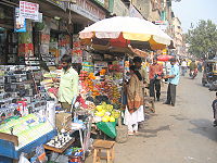 A part of Chandni Chowk Street
 -

-
 Statue ofUtkalmani Pandit Gopabandhu Das
 -
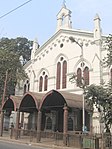 Thoburn Memorial Methodist Church, established in 1873
 -
 A closer view ofTipu Sultan Mosque


References
[edit]- ^The Madras Catholic Directory and General Annual Register for the Year of our Lord 1870.Examiner Press. 1869. p. 187.Retrieved9 March2024.
- ^abcdeCotton, H.E.A.,Calcutta Old and New,1909/1980, pp. 248-50, General Printers and Publishers Pvt. Ltd.
 This article incorporates text from this source, which is in thepublic domain.
- ^Ghosh, Binoy,Paschim Banger Sanskriti,(in Bengali), part II, 1978 edition, p. 252, Prakash Bhaban
- ^Map nos. 29, 30, and 32, Detail Maps of 141 Wards of Kolkata, D.R.Publication and Sales Concern, 66 College Street, Kolkata – 700073
- ^Nair, P. Thankappan,The Growth and Development of Old Calcutta,inCalcutta, the Living City,Vol. I, edited bySukanta Chaudhuri,p. 11, Oxford University Press,ISBN978-0-19-563696-3.
- ^Cotton, H.E.A., p. 72
- ^Lahiri Choudhury, Dhriti Kanta,Trends in Calcutta Architecture,inCalcutta, the Living City,Vol I, pp.159-160
- ^Cotton, H.E.A., p. 219
- ^Cotton, H.E.A., p. 771
- ^Nair, P. Thankappan,The Growth and Development of Old Calcutta,p. 15.
- ^Nair, P.Thankappan,Civic and Public Services in Old Calcutta,inCalcutta, the Living City,Vol I, pp. 234-6
- ^Google maps
- ^"Better Kolkata Campaign".The Statesman, 17 June 2002. Archived fromthe originalon 29 September 2007.Retrieved2007-07-25.
- ^Chakraborti, Dipankar,Calcutta's Environment,p.185, inCalcutta, the Living City,Vol II
- ^Mukherjee, Shankar (18 August 2003)."Bypass, Setu sites for twin central bus terminals".Calcutta, India: The Telegraph, 18 August 2003. Archived fromthe originalon 22 August 2003.Retrieved25 July2007.
- ^Konar, Debashis (24 January 2003)."Breather for choking esplanade?".Times of India, 24 January 2003.Retrieved25 July2007.
External links
[edit]![]() Kolkata/Esplanadetravel guide from Wikivoyage
Kolkata/Esplanadetravel guide from Wikivoyage