
Dodoni
Dodoni
Δωδώνη | |
|---|---|
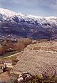
 View of Dodoni and mountTomaros | |
 Dodoni Location within the region  | |
| Coordinates:39°33′N20°46′E/ 39.550°N 20.767°E | |
| Country | Greece |
| Administrative region | Epirus |
| Regional unit | Ioannina |
| Area | |
| • Municipality | 657.5 km2(253.9 sq mi) |
| • Municipal unit | 101.0 km2(39.0 sq mi) |
| • Community | 8.748 km2(3.378 sq mi) |
| Population (2021)[1] | |
| • Municipality | 7,199 |
| • Density | 11/km2(28/sq mi) |
| • Municipal unit | 937 |
| • Municipal unit density | 9.3/km2(24/sq mi) |
| • Community | 185 |
| • Community density | 21/km2(55/sq mi) |
| Time zone | UTC+2(EET) |
| • Summer (DST) | UTC+3(EEST) |
| Vehicle registration | ΙΝ |
Dodoni(Greek:Δωδώνη) is a village and a municipality in theIoanninaregional unit,Epirus,Greece.The seat of the municipality is the village Agia Kyriaki (communityTheriakisi).[2]
The modern village of Dodoni is located near the ancient city of same name and site of the ancient oracle ofDodona.Oedipus the Kingwas shot here in 1967.
Municipality
[edit]The present municipality Dodoni was formed at the 2011 local government reform by the merger of the following 4 former municipalities, that became municipal units:[2]
- Agios Dimitrios
- Dodoni
- Lakka Souliou
- Selloi
The municipality Dodoni has an area of 657.499 km2,the municipal unit Dodoni has an area of 101.016 km2,and the community Dodoni has an area of 8.748 km2.[3]
Gallery
[edit]-
 Theatre at Dodoni
 -
 View on theatre and MountTomaros


References
[edit]- ^"Αποτελέσματα Απογραφής Πληθυσμού - Κατοικιών 2021, Μόνιμος Πληθυσμός κατά οικισμό"[Results of the 2021 Population - Housing Census, Permanent population by settlement] (in Greek). Hellenic Statistical Authority. 29 March 2024.
- ^ab"ΦΕΚ A 87/2010, Kallikratis reform law text"(in Greek).Government Gazette.
- ^"Population & housing census 2001 (incl. area and average elevation)"(PDF)(in Greek). National Statistical Service of Greece. Archived fromthe original(PDF)on 2015-09-21.
| Regional unit ofArta |  | |
|---|---|---|
| Regional unit ofIoannina | ||
| Regional unit ofPreveza | ||
| Regional unit ofThesprotia | ||
| ||
ThisEpiruslocation article is astub.You can help Wikipedia byexpanding it. |