Drino
Appearance
| Drino | |
|---|---|
 Drino River | |
| Location | |
| Countries | AlbaniaandGreece |
| Physical characteristics | |
| Source | |
| • location | Ioannina regional unit,Greece |
| Mouth | |
• location | Vjosë |
• coordinates | 40°17′12″N20°2′32″E/ 40.28667°N 20.04222°E |
| Length | 84.6 km (52.6 mi) |
| Basin size | 1,320 km2(510 sq mi)[1] |
| Basin features | |
| Progression | Vjosë→Adriatic Sea |
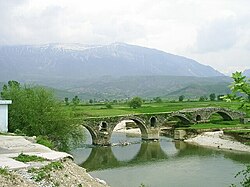
TheDrinoorDrinos(Albanian:Drino,Greek:Δρίνος) is ariverin southernAlbaniaand northwesternGreece,and a tributary of theVjosë.Its source is in the northwestern part of theIoannina regional unit,near the villageDelvinaki.The 84.6 km (52.6 mi) long Drino flows initially southwest, then northwest and crosses the Albanian border nearKtismata.It continues northwest throughGjirokastërand flows into the Vjosë nearTepelenë.
Name
[edit]TheAlbanianname of the river isDrinoand theGreekname is Δρίνος,Drinos.The name of the river contains the rootDrin-,which is considered to be ofIllyrianorigin and is encountered also in the northern Albanian riverDrin(cf. alsoDrinabetweenBosnia and HerzegovinaandSerbia).[2]
See also
[edit]References
[edit]- ^"Rivers of Europe".researchgate.net.p. 3.
- ^Demiraj, Shaban(2006).The origin of the Albanians: linguistically investigated.Academy of Sciences of Albania.pp. 146, 148−149.ISBN9789994381715.Archived fromthe originalon 20 November 2020.
Wikimedia Commons has media related toDrino River.
Categories:
- Tributaries of the Aoös
- Rivers of Albania
- Rivers of Greece
- International rivers of Europe
- Landforms of Ioannina (regional unit)
- Rivers of Epirus (region)
- Geography of Gjirokastër County
- Pindus
- Braided rivers in Albania
- Gjirokastër County geography stubs
- Epirus geography stubs
- Greece river stubs
- Europe river stubs
- Albania geography stubs
