Dry line
The examples and perspective in this articledeal primarily with the United States and do not represent aworldwide viewof the subject.(March 2018) |

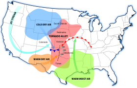
Adry line(also calleda dew point line,orMarfa front,afterMarfa, Texas)[1]is a line across a continent that separates moist air and dry air. One of the most prominent examples of such a separation occurs in centralNorth America,especially Texas, Oklahoma, and Kansas, where the moist air from theGulf of Mexicomeets dry air from the desert south-western states. The dry line is an important factor insevere weatherfrequency in theGreat PlainsofNorth America.It typically lies north-south across theHigh Plainsstates in the warm sector of anextratropical cycloneand stretches into theCanadian Prairiesduring the spring and early summer.[citation needed]The dry line is also important for severe convective storms in other regions of the world, such as northernIndiaandSouthern Africa.[2]In general, thunderstorms and other forms of severe weather occur on the moist side of the dryline.
Characteristics
[edit]
Near the surface, warm dry air is denser than warm moist air of lesser or similartemperature,and thus the warm dry air wedges under the moist air like a cold front.[3][4] At higher altitudes, the warm moist air is less dense than the cooler, drier air and the boundary slope reverses. In the vicinity of the reversal aloft, severe weather is possible, especially when a triple point is formed with acold front.The dry line is most common in thespring.[5]Its location is close to the location of the 55 °F (13 °C) isodrosotherm, or line of equaldewpoint.The location of the dryline may not be marked with a surface pressuretroughor shift of thewinddirection. It bulges more to the east underneath the location of the highest winds within thejet stream.[6]While dry lines are most common in theGreat Plains,northern India also witnesses a similar moisture boundary.[7]In northeast India, it occurs mainly before the onset of their summermonsoon,[8]while northwest India experiences it during the monsoon season.[9]
Daily progression in North America
[edit]The dry line typically advances eastward during the afternoon and retreats westward at night, mainly due to the increased mi xing down to the surface of moist air aloft, rather than the air mass' surface density contrast. The movement of the dry line during daylight hours is quickest in areas where low level moisture is most shallow, as dryline movement slows in areas with deeper low-level moisture. Weaker winds aloft also slow its progression.[10]However, a strong storm system can sweep the dry line eastward into theMississippi ValleyorTexas/Louisianaborder, regardless of the time of day. Stronger dry line passages result in a sharp drop indew point,clearing skies, and awindshift from south or south-easterly to west or south-westerly. Blowingdustand risingtemperaturesalso may follow, especially if the dry line passes during the daytime. These changes occur in reverse order when the dry line retreats westward during the evening and nighttime hours. Severe and sometimestornadicthunderstormsoften develop along the slope-reversal zone east of the surface dry line, especially when it begins moving eastward.
Associated weather
[edit]In the dry sector west of the dry line, clear skies are the rule due to the dryness of theair masssweeping in from theDesert SouthwestinNorth America,[11]and theAravalli rangein India.[9]If winds are strong enough,dust stormscan develop.[7]Cumulus cloudsare common east of the dry line in the moist sector, though they are taller with greater development along the dry line itself.[12]The moist sector is normally capped with a lid of an elevated mixed drier layer which represents subsidence from aloft as the surface air cools and contracts at night. The same process promotes the development of a low level jet to the east of the dryline. During the daytime, if heating and/or convergence are sufficient, the cap can be broken, resulting in convective clouds.[7]
See also
[edit]References
[edit]- ^Scott Girhard (2007-05-04)."Lecture 3 - Thunderstorms".San Antonio College. Archived fromthe originalon 2007-09-27.Retrieved2008-03-15.
- ^>Howard, E., and R. Washington, 2019: Drylines in Southern Africa: Rediscovering the Congo Air Boundary. J. Climate, 32, 8223–8242,https://doi.org/10.1175/JCLI-D-19-0437.1.
- ^Carlson and Ludlam, "Conditions for the occurrence of severe local storms", orig. Tellus, Vol.20, No.2, pp.203-226 (May 1968), republished online atWiley Online Library, March 18, 2010
- ^Huaqing Cai (2001-09-24)."Dryline cross section".University of California Los Angeles.Archived fromthe originalon 2008-01-20.Retrieved2006-12-05.
- ^Glossary of Meteorology (June 2000)."Dryline".American Meteorological Society.Archived fromthe originalon 2011-06-06.Retrieved2010-04-25.
- ^Daniel Dix (June 2000)."Dryline Thunderstorms".The Weather Channel.Archived fromthe originalon 2007-07-29.Retrieved2010-04-25.
- ^abcT. N. Carlson (1991).Mid-Latitude Weather Systems.HarperCollinsAcademic. pp. 449–481.ISBN978-0-04-551116-7.
- ^K. J. Weston (1972-03-07)."The dry-line of Northern India and its role in cumulonimbus convection".Quarterly Journal of the Royal Meteorological Society.98(417): 519–531.Bibcode:1972QJRMS..98..519W.doi:10.1002/qj.49709841704.Archived fromthe originalon 2013-01-05.Retrieved2010-04-25.
- ^abSen Chiao andAna P. Barros(2007)."A Numerical Study of the Hydrometeorological Dryline in Northwest India During the Monsoon".Journal of the Meteorological Society of Japan.85A:337–361.Bibcode:2007JMeSJ..85A.337C.doi:10.2151/jmsj.85A.337.ISSN0026-1165.
- ^Todd Lindley (1997-09-01)."Effects of Texas Panhandle Topography on Dryline Movement".National Weather ServiceSouthern Region Headquarters.Retrieved2010-04-25.
- ^National Severe Storms Laboratory(2006-10-11)."Tornado Climatology".National Oceanic and Atmospheric Administration.Archived fromthe originalon 2012-03-20.Retrieved2010-04-25.
- ^Michael William Carr (1999).International Marine's Weather Predicting Simplified: How to Read Weather Maps.McGraw-Hill Professional. p. 70.ISBN978-0-07-012031-0.Retrieved2010-04-25.
