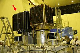
EgyptSat 1
 EgyptSat 1 (left) and Saudi Sat 3 (right) | |
| Mission type | Remote sensing |
|---|---|
| Operator | NARSS |
| COSPAR ID | 2007-012A[1] |
| SATCATno. | 31117[1] |
| Website | www |
| Mission duration | Planned: 5 years; Achieved: 3 years, 3 months, 2 days |
| Spacecraft properties | |
| Bus | MS-1TK[2] |
| Manufacturer | Yuzhnoye Design Bureau |
| Launch mass | 165 kilograms (364 lb)[3][4] |
| Power | 65 watts[5] |
| Start of mission | |
| Launch date | April 17, 2007, 07:02UTC |
| Rocket | Dnepr |
| Launch site | Baikonur109/95 |
| Contractor | ISC Kosmotras |
| End of mission | |
| Last contact | July 19, 2010[6] |
| Orbital parameters | |
| Reference system | Geocentric |
| Regime | Sun-Synchronous |
| Perigee altitude | 658 kilometres (409 mi)[7] |
| Apogee altitude | 666 kilometres (414 mi)[7] |
| Inclination | 98.1 degrees[7] |
| MainPush broom scanner[4] | |
| Name | EgyptSat 1 |
| Resolution | 7.8 metres (26 ft)(MBEI)[4] 39 metres (128 ft) (cross-track) x 46 metres (151 ft) (along-track)(IREI)[4] |
EgyptSat | |
EgyptSat 1orMisrSat-1wasEgypt's firstEarthremote sensingsatellite.This satellite was jointly built by Egypt'sNational Authority for Remote Sensing and Space Sciencestogether with theYuzhnoye Design BureauinUkraineand was launched on board aDnepr rocketon 17 April 2007 from theBaikonur Cosmodrome.
The effort was spearheaded by Dr. Aly Sadek, chairman of the Egyptian Council for Space Science and Technology Research. It in many ways was considered a huge step for the Egyptians since it marked the first time they opted for technology transfer during the manufacturing the satellite rather than simply purchasing one (as in case of theNilesatsatellites). On 23 October 2010, the National Authority for Remote Sensing and Space Sciences announced that control and communication with the satellite had been lost since July 2010.[8][9][10]
History[edit]
In 2001, Egypt posted an international tender for the development of the first Egyptian satellite for the observation and remote sensing and bidders from Ukraine, UK, Russia, Korea and Italy competed for the deal.[2][11]
on June 26, 2001 KB Yuzhnoe design bureau from Ukraine announced winner and on October 24, a contract had been signed in Egypt.[12]
A consortium consisted of KB Yuzhnoe design bureau and sub-contractors Ukrainian companies:[2][4][12]
- Yuzhnoye- prime contractor responsible for the platform and the launch
- Yuzhmash- Scientific Research Institute of Radio Engineering Measurements
- Khartron-KonsatandKhartron-Yukom- Research and Scientific Production Enterprises
- KONEX- State Research and Production Enterprise
- CONECS- responsible for the development of the two optical payloads, the onboard payload command and data handling subsystem, as well as for the development of the data processing in theground segment
- Arsenal- optics manufacturing
Achievements and future plans[edit]
- EgyptSat 1 Launched successfully on April 17, 2007.
- EgyptSat 2with spatial resolution of 5.4 metres (18 ft)[3]was planned to be launched on October 1, 2013 but the launch was put on hold in 2011 following all contact being lost with EgyptSat 1.[13][14]EgyptSat 2 launched into orbit 16 April 2014; last contact with the satellite was April 14, 2015.
- DesertSat with spatial resolution of 2.5 metres (8 ft 2 in)[3]which specialized in identifying and monitoring desert resources[6]is planned to be launched in 2017.[15]
The objective of the three satellites is to provide comprehensive images of Egypt.
Equipment[edit]
Egyptsat 1 is considered aminiaturized satelliteweighing 100 kg and is carrying two devices: an infrared sensing device and a high resolution multispectral imager together withstore and forwardcommunications payload.
See also[edit]
References[edit]
- ^ab"EgyptSat 1".National Space Science Data Center Administration - National Aeronautics and Space Administration.Archivedfrom the original on 29 March 2016.Retrieved23 August2013.
- ^abc"EgyptSat-1".russianspaceweb.Archived fromthe originalon 18 June 2014.Retrieved1 September2014.
- ^abcAbd Al-Rahman, Zahraa."Assessment Of Egyptian Satellite (EGYPT SAT-1) Images For The Production and Updating Of 1:25000 Planimetric Maps"(PDF).Association of American Geographers.Archived fromthe original(PDF)on 2 December 2012.Retrieved23 August2013.
- ^abcdeKramer, Herbert J."EgyptSat-1".eoPortal Directory.Archivedfrom the original on 21 October 2013.Retrieved23 August2013.
- ^"Hartron-Arkos, Control systems for space and ground applications".Archived fromthe originalon 2012-03-08.Retrieved2013-08-19.
- ^ab"Archived copy"(PDF).Archived fromthe original(PDF)on 2014-04-13.Retrieved2013-08-19.
{{cite web}}:CS1 maint: archived copy as title (link) - ^abc"EgyptSat 1".National Space Science Data Center Administration (Goddard Space Flight Center).National Aeronautics and Space Administration.Archivedfrom the original on 29 March 2016.Retrieved23 August2013.
- ^"اختفاء القمر الصناعي المصري «إيجبت سات 1» | المصري اليوم، أخبار اليوم من مصر".Archivedfrom the original on 2010-10-25.Retrieved2010-10-25.
- ^"خبير: القمر مصر سات انتهى عمره الافتراضي بعد نصف المدة.. وفرصة استعادته ضعيفة".Archived fromthe originalon 2010-10-28.Retrieved2010-10-25.
- ^"هيئة الاستشعار: فقدنا الاتصال والسيطرة على القمر البحثيايجبت سات1".Archived fromthe originalon 2010-10-26.Retrieved2010-10-25.
- ^"Russian application satellites - Ukraine to build satellite for Egypt".russianspaceweb.Archived fromthe originalon 7 October 2014.Retrieved1 September2014.
- ^ab"Ukraine's Space Program".Moscow Defense Brief.Archivedfrom the original on 3 September 2014.Retrieved1 September2014.
- ^"Page redirection".Archived fromthe originalon 2013-02-03.
- ^"EgyptSat 2 (MisrSat 2)".Archivedfrom the original on 2016-10-17.Retrieved2013-08-19.
- ^http:// freedominion.pa/phpBB2/viewtopic.php?p=1011884[dead link]
