El Dorado State Park
| El Dorado State Park | |
|---|---|
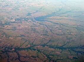
 El Dorado Reservoir - aerial view looking north | |
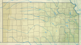
| Location | Butler,Kansas,United States |
| Coordinates | 37°51′40″N96°46′19″W/ 37.86111°N 96.77194°W |
| Area | 4,500 acres (18 km2) |
| Elevation | 1,352 ft (412 m)[1] |
| Established | 1981 (Reservoir) |
| Visitors | 1,615,212 (in 2022)[2] |
| Governing body | Kansas Department of Wildlife, Parks and Tourism |
El Dorado State Parkis astate parkinButler County, Kansas,United States, located just north ofEl Dorado.
The largest of Kansas' state parks, El Dorado is nestled in the scenicFlint Hillsand sprawls across 4,000 acres (16 km2) along the eastern and western shores ofEl Dorado Reservoir.Crappieandlargemouth bassfishing are good in standing timber and around fish attractors.Walleyefishing is good along the face of the dam and on the oldrailroadbed.Channel catfishis good lakewide, as well as in the river below the outlet.Flatheadfishing is good in a variety of areas, especiallyOld Bluestem Lake.
Regarded as one of the state's mosthandicapped accessibleparks, El Dorado contains 1,100 campsites which offer visitors a range of choices. Other facilities include two swimming beaches, 10 group shelters, and a 24-site group campground. A largeamphitheateraccommodates a variety of concerts and festivals. Trail users will find a variety of attractions, including a designatedhorsecampground.
See also
[edit]References
[edit]- ^"El Dorado State Park".Geographic Names Information System.United States Geological Survey.October 13, 1978.RetrievedNovember 26,2012.
- ^Self, Matthew (August 18, 2023)."Top 5 most popular Kansas state parks revealed".KSNT.
External links
[edit]- "El Dorado State Park".Kansas Department of Wildlife, Parks and Tourism.RetrievedNovember 11,2012.

