
Elba
Native name: Isola d'Elba | |
|---|---|
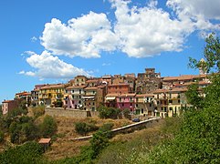
 Seen from the west,Monte Capannein foreground | |
 | |
| Geography | |
| Location | Tyrrhenian Sea |
| Coordinates | 42°46′48″N10°16′30″E/ 42.78000°N 10.27500°E |
| Archipelago | Tuscan Archipelago |
| Total islands | 7 |
| Major islands | Elba,Gorgona,Capraia,Pianosa,Montecristo,Isola del Giglio,andGiannutri |
| Area | 224 km2(86 sq mi) |
| Length | 29 km (18 mi) |
| Width | 18 km (11.2 mi) |
| Coastline | 147 km (91.3 mi) |
| Highest elevation | 1,018 m (3340 ft) |
| Highest point | Monte Capanne |
| Administration | |
Italy | |
| Region | Tuscany |
| Province | Livorno |
| Communesof Elba | Portoferraio,Campo nell'Elba,Capoliveri,Marciana,Marciana Marina,Porto Azzurro,Rio |
| Largest settlement | Portoferraio(pop. 12,011) |
| Demographics | |
| Population | 31,592 (January 2019[1]) |
| Pop. density | 140/km2(360/sq mi) |

Elba(Italian:isola d'Elba,pronounced[ˈiːzolaˈdelba];Latin:Ilva) is aMediterraneanisland inTuscany,Italy,10 km (6.2 mi) from the coastal town ofPiombinoon the Italian mainland, and the largest island of theTuscan Archipelago.It is also part of theArcipelago Toscano National Park,[2]and the third largestisland in Italy,afterSicilyandSardinia.It is located in theTyrrhenian Seaabout 50 km (30 mi) east of the French island ofCorsica.
The island is part of theprovince of Livornoand is divided into seven municipalities, with a total population of about 30,000 inhabitants which increases considerably during the summer. The municipalities arePortoferraio(which is also the island's principal town),Campo nell'Elba,Capoliveri,Marciana,Marciana Marina,Porto Azzurro,andRio.
It is famous for being the site ofNapoleon's first exile, from 1814 to 1815.
Geography
[edit]Elba is the largest remaining stretch of land from the ancient tract that once connected the Italian peninsula to Corsica.[citation needed]The northern coast faces the Ligurian Sea, the eastern coast the Piombino Channel, the southern coast the Tyrrhenian Sea, and the Corsica Channel divides the western tip of the island from neighbouring Corsica.
Geology
[edit]The island itself is made up of slices of rocks which once formed part of the ancientTethyanseafloor.[3]These rocks have been through at least twoorogenies,theAlpine orogenyand theApennine orogeny.The second of these two events was associated with subduction of theTethyanoceanic crust underneathItalyand the obduction of parts of the ancient seafloor onto the continents. Later extension within the stretched inner part of theApennine mountainscaused adiabatic melting and the intrusion of theMount Capanneand the La Serra-Porto Azzuro granitoids. These igneous bodies brought with themskarnfluids which dissolved and replaced some of the carbonate units, precipitatingiron-rich minerals in their place. One of theiron-rich minerals,ilvaite,was first identified on the island and takes its name from theLatinword for Elba. More recently, high-angle faults formed within the tectonic pile, allowing for the migration ofiron-rich fluids through the crust. The deposits left behind by these fluids formed the island's rich seams ofiron ore.

The terrain is quite varied and is thus divided into several areas based ongeomorphology.The mountainous and most recent part of the island can be found to the west, the centre of which is dominated byMount Capanne(at a height of 1,018 metres, or 3,340 feet), also called the "roof of the Tuscan Archipelago". The mountain is home to many animal species including themouflonandwild boar,two species that flourish despite the continuous influx of tourists. The central part of the island is a mostly flat section with the width being reduced to just four kilometres (2.5 mi). It is where the major centres can be found: Portoferraio, Campo nell'Elba. To the east is the oldest part of the island, formed over 3 million years ago.[4]In the hilly area, dominated by Monte Calamita, are the deposits ofironthat made Elba famous.
Hydrography
[edit]Rivers rarely exceed 3 km (2 mi) in length, and it is common for the shorter ones to dry up during the summer. The largest rivers, sorted by length, are:
- Fosso San Francesco 6.5 km (4.0 mi);
- Fosso Barion, 5.1 km (3.2 mi);
- Fosso Redinoce, 2 km (1.2 mi)
Between Poggio and Marciana, at the foot of Mount Capanne, is a spring called Fonte Napoleone, known for its quality.
Climate
[edit]The climate of the island is predominantly Mediterranean, except for Mount Capanne, where winters tend to be moderately cold. Precipitation is concentrated in autumn and comprises a normal rainfall. The island lies in therain shadowof the large and mountainous island of Corsica, so precipitation totals are somewhat reduced from the mainland (most of the island receives less than 750 mm (30 inches) annually). Snowfall in winter is rare in the lowlands and melts quickly. The table below shows the average temperatures for the islands by month.
| Climate data for Monte Calamita, Elba Island | |||||||||||||
|---|---|---|---|---|---|---|---|---|---|---|---|---|---|
| Month | Jan | Feb | Mar | Apr | May | Jun | Jul | Aug | Sep | Oct | Nov | Dec | Year |
| Mean daily maximum °C (°F) | 9.9 (49.8) |
10.2 (50.4) |
12.7 (54.9) |
15.5 (59.9) |
19.7 (67.5) |
24.0 (75.2) |
27.4 (81.3) |
27.8 (82.0) |
23.5 (74.3) |
18.8 (65.8) |
14.2 (57.6) |
10.9 (51.6) |
17.9 (64.2) |
| Daily mean °C (°F) | 7.8 (46.0) |
7.7 (45.9) |
9.8 (49.6) |
12.5 (54.5) |
16.3 (61.3) |
20.4 (68.7) |
23.6 (74.5) |
24.0 (75.2) |
20.2 (68.4) |
16.3 (61.3) |
12.1 (53.8) |
8.8 (47.8) |
15.0 (58.9) |
| Mean daily minimum °C (°F) | 5.7 (42.3) |
5.3 (41.5) |
7.1 (44.8) |
9.6 (49.3) |
13.2 (55.8) |
16.9 (62.4) |
19.9 (67.8) |
20.4 (68.7) |
17.0 (62.6) |
13.9 (57.0) |
10.0 (50.0) |
6.9 (44.4) |
12.2 (53.9) |
| Averageprecipitationmm (inches) | 48.3 (1.90) |
52.5 (2.07) |
47.2 (1.86) |
43.6 (1.72) |
39.5 (1.56) |
25.1 (0.99) |
15.4 (0.61) |
20.0 (0.79) |
66.5 (2.62) |
74.4 (2.93) |
82.6 (3.25) |
63.1 (2.48) |
578.2 (22.78) |
| Average precipitation days(≥ 1.0 mm) | 6.27 | 6.27 | 5.70 | 5.67 | 5.22 | 2.85 | 1.46 | 1.73 | 4.81 | 6.15 | 7.92 | 7.76 | 61.81 |
| Averagerelative humidity(%) | 77.54 | 74.00 | 72.77 | 72.66 | 72.79 | 71.04 | 68.82 | 70.33 | 74.06 | 78.45 | 79.95 | 78.16 | 74.21 |
| Averagedew point°C (°F) | 4.1 (39.4) |
3.1 (37.6) |
4.9 (40.8) |
7.5 (45.5) |
11.2 (52.2) |
14.8 (58.6) |
16.9 (62.4) |
17.7 (63.9) |
15.1 (59.2) |
12.3 (54.1) |
8.8 (47.8) |
5.2 (41.4) |
10.1 (50.2) |
| Source:NOAA[5] | |||||||||||||
| Climate data for Elba | |||||||||||||
|---|---|---|---|---|---|---|---|---|---|---|---|---|---|
| Month | Jan | Feb | Mar | Apr | May | Jun | Jul | Aug | Sep | Oct | Nov | Dec | Year |
| Record high °C (°F) | 17.6 (63.7) |
18.0 (64.4) |
22.0 (71.6) |
24.6 (76.3) |
29.6 (85.3) |
33.4 (92.1) |
35.0 (95.0) |
37.2 (99.0) |
32.0 (89.6) |
27.0 (80.6) |
24.6 (76.3) |
17.2 (63.0) |
37.2 (99.0) |
| Mean daily maximum °C (°F) | 9.6 (49.3) |
10.0 (50.0) |
12.0 (53.6) |
14.2 (57.6) |
18.8 (65.8) |
22.7 (72.9) |
26.5 (79.7) |
26.7 (80.1) |
22.6 (72.7) |
18.0 (64.4) |
13.4 (56.1) |
10.5 (50.9) |
17.1 (62.8) |
| Daily mean °C (°F) | 7.4 (45.3) |
7.5 (45.5) |
9.2 (48.6) |
11.4 (52.5) |
15.6 (60.1) |
19.3 (66.7) |
22.7 (72.9) |
23.1 (73.6) |
19.5 (67.1) |
15.4 (59.7) |
11.2 (52.2) |
8.5 (47.3) |
14.2 (57.6) |
| Mean daily minimum °C (°F) | 5.3 (41.5) |
5.0 (41.0) |
6.3 (43.3) |
8.5 (47.3) |
12.3 (54.1) |
15.8 (60.4) |
19.0 (66.2) |
19.5 (67.1) |
16.4 (61.5) |
12.9 (55.2) |
9.0 (48.2) |
6.5 (43.7) |
11.4 (52.5) |
| Record low °C (°F) | −7.4 (18.7) |
−5.4 (22.3) |
−5.4 (22.3) |
1.2 (34.2) |
3.4 (38.1) |
5.0 (41.0) |
12.2 (54.0) |
11.6 (52.9) |
7.6 (45.7) |
2.0 (35.6) |
−1.0 (30.2) |
−5.4 (22.3) |
−7.4 (18.7) |
| Averageprecipitationmm (inches) | 59.5 (2.34) |
75.6 (2.98) |
56.2 (2.21) |
57.8 (2.28) |
31.6 (1.24) |
26.8 (1.06) |
13.8 (0.54) |
41.5 (1.63) |
75.0 (2.95) |
101.6 (4.00) |
88.7 (3.49) |
50.5 (1.99) |
678.6 (26.71) |
| Average precipitation days(≥ 1.0 mm) | 6.7 | 6.2 | 6.9 | 7.0 | 5.0 | 3.5 | 1.6 | 2.4 | 5.0 | 7.9 | 7.3 | 5.8 | 65.3 |
| Averagerelative humidity(%) | 77 | 76 | 75 | 76 | 76 | 73 | 68 | 72 | 76 | 80 | 81 | 79 | 76 |
| Mean monthlysunshine hours | 133.3 | 118.7 | 155.0 | 183.0 | 195.3 | 237.0 | 275.9 | 257.3 | 201.0 | 151.9 | 117.0 | 114.7 | 2,140.1 |
| Source 1: Servizio Meteorologico (temperature and precipitation data 1971–2000),[6]NOAA(Extremes 1991-2020)[5] | |||||||||||||
| Source 2: Servizio Meteorologico (relative humidity and sun data 1961–1990)[7] | |||||||||||||
History
[edit]


Early history
[edit]The island was originally inhabited byLiguresIlvatesand was calledIlva(Ἰλούα). It was well known from very ancient times for itsironresources and valued mines. TheGreeksalso called itAethalia(Αἰθαλία or Αἰθάλεια) andAethale(Αἰθάλη) from "smoky" (αἰθάλη), after the fumes of the metal producing furnaces.[8]
Apollonius of Rhodesmentions it in his epic poemArgonautica,describing that theArgonautsrested here during their travels. He writes that signs of their visit were still visible in his day, including skin-coloured pebbles that they dried their hands on and large stones which they used at discus.Strabo(5.2.6) presents a slightly different account: "because the scrapings, which the Argonauts formed when they used theirstrigils,became congealed, the pebbles on the shore remain variegated still to this day. "[9]The port which is now called Porto Ferraio, was known in ancient times as the portus Argous (Ἀργῶος λιμήν), because it was believed that the Argonauts landed there on their return voyage.[8]
The island was then settled by theEtruscans,who started mining iron at Elba, and later (after 480 BC) by theRomans,who called the island Ilva.[10]
Middle Ages and early modern
[edit]In the earlymedieval period,Elba was invaded by the Ostrogoths and theLombards,and later it became a possession of theRepublic of Pisa.After thebattle of Meloria,theRepublic of Genoatook possession of Elba, but it was regained by Pisa in 1292.[11]The island was retained for two centuries by theAppiani family,Lords ofPiombino,when they sold Pisa to thehouse of Viscontiof Milan in 1399.
In 1544, theBarbary piratesfrom North Africa devastated Elba and the coasts of Tuscany.[12]In 1546, part of the island was handed over toCosimo I de' Medici, Grand Duke of Tuscany,who fortified Portoferraio and renamed it "Cosmopoli", while the rest of the island was returned to the Appiani in 1577. In 1596,Philip II of Spaincaptured Porto Longone and had two fortresses built there. This part of Elba came into the direct power of Spain through theState of the Presidi,includingPorto Longone.In 1736, the sovereignty of this part of Elba was claimed by theKingdom of Naplesbut remained abandoned.[13]
Late modern and contemporary
[edit]TheBritishlanded on the island of Elba in 1796, after the occupation ofLivornoby theFrench Republicantroops, to protect the 4,000 French royalists who had found asylum in Portoferraio two years earlier. In 1801, thePeace of Lunevillegave Elba to theKingdom of Etruria,and it was transferred to France in 1802 by thePeace of Amiens.[14][15]
The French EmperorNapoleonwasexiled to Elba,after his forced abdication following theTreaty of Fontainebleau,and conveyed to the island onHMSUndauntedby CaptainThomas Ussher;he arrived at Portoferraio on 4 May 1814.[16]He was allowed to keep a personal guard of 400 men[17]and was nominallysovereign of Elba,a step down from Emperor of the French. However, the nearby sea was patrolled by theFrenchandBritish naviesto ensure he could not escape. During the months that he stayed on the island, Napoleon carried out a series of economic and social reforms to improve the quality of life. After staying for almost ten months, he managed to escape back to France on 26 February 1815 with about 1,000 men.
At theCongress of Vienna,Elba was given to theGrand Duchy of Tuscany.In 1860, it became part of the new unifiedKingdom of Italy.
During theSecond World War,the island was liberated from German occupation by the French1erCorps d'Arméesupported by British forces including Royal Naval Commandos on 17 June 1944, inOpération Brassard.Faulty intelligence and strong defences made the battle more difficult than expected.[18][19]
In 1954,BOAC Flight 781crashed in the waters off the coast of Elba.[20]
In recent decades, thanks to its rich cultural heritage, cuisine and nature, the island has become an important international tourist destination.[21]
Transportation
[edit]The island is connected to the mainland via the four ferry companies,Toremar,Moby Lines,BlunavyandSardinia Ferries,[22]all offering routes between Piombino and Portoferraio, the capital located in the north,Cavo,Rio Marinaand Porto Azzurro, on the east coast of the island.[23][24][25][26][27]
There is an airport on the island,Marina di Campo Airport.It is served bySilver Airwith flights to the Italian mainland.[28]
Cycling
[edit]The island has a network of trails for road racers looking for more technical routes for their training, trails and dirt roads for bikers to have fun on, and accessible routes for families with children who need safe and rela xing routes. On the road fromRio nell'Elbagoing to Porto Azzurro is the "Fonte di Coppi". Towards the end of his career,Fausto Coppi,the "campionissimo", came here to train on the roads of Elba. He still retained a celebrity status but was no longer at the peak of his career that ended with his death a few years later. The plaque on the fountain reads: "1960–2010, here the champion quenched his thirst, after fifty years on the run".
Sport
[edit]
 | |
| Association | Elba Island Football Association |
|---|---|
| Confederation | CONIFA |
| First international | |
(Sicily;11 September 2021) | |
| Biggest win | |
(Capoliveri,Elba; 16 July 2022) | |
| Biggest defeat | |
(Capoliveri,Elba; 11 September 2021) | |
The Elba football team represents the island. They were approved as aConIFAmember at the Annual General Meeting 2020.[29]It is not affiliated withFIFAorUEFA,and therefore cannot compete for theFIFA World Cupor in theUEFA European Championship.It is, however, affiliated toConIFA,and play in theConIFA European Football Cup.
Elba Island played their first game as aConIFAmember on 11 September 2021 against the Sicily Football Team scoring a 4–4 tie against them.[29]
Gallery
[edit]-
 Enfola Beach
 -

-
-
 Fetovaia beach
 -
-
 Schiaccia briaca (drunken cake) from Elba and Aleatico (Elban wine) used in the recipe


See also
[edit]- List of islands of Italy
- Tuscan Archipelago
- The Count of Monte Cristo,1844 novel by Alexandre Dumas
References
[edit]- ^"Istat official population estimates".Archived fromthe originalon 24 July 2019.Retrieved30 March2020.
- ^"Elba".Parco nazionale dell'Arcipelago Toscano. 16 February 2009. Archived fromthe originalon 28 May 2013.Retrieved15 January2012.
- ^"The association of continental crust rocks with ophiolites in the Northern Apennines (Italy): implications for the continent-ocean transition in the Western Tethys"(PDF).els-cdn.
- ^Bortolotti, Valerio; Fazzuoli, Milvio; Pandeli, Enrico; Principi, Gianfranco; Babbini, Amedeo; Corti, Simone (2001)."Login".Ofioliti.26(2a): 97–150.
- ^ab"WMO Climate Normals for 1991-2020: Monte Calamita-16197"(CSV).ncei.noaa.gov(Excel).National Oceanic and Atmosoheric Administration.Retrieved29 February2024.
- ^"Elba/M. Calamita"(PDF).Servizio Meteorologico.Retrieved13 October2012.
- ^"Monte Calamita – Elba".Servizio Meteorologico.Retrieved13 October2012.
- ^abDictionary of Greek and Roman Geography (1854), Ilva
- ^Race, W. H. (2008).Apollonius Rhodius: Argonautica.Vol. II. Loeb Classical Library. pp. 654–58, 381–3.See note 95, p. 383 for Strabo quote.
- ^"Elba ISLAND, ITALY".britannica.Encyclopaedia Britannica.Retrieved29 March2020.
- ^"History of Elba Island".elbaworld.[permanent dead link]
- ^David, Robert C. (2004).Christian Slaves, Muslim Masters: White Slavery in the Mediterranean, the Barbary Coast and Italy, 1500–1800.Palgrave Macmillan.ISBN1-4039-4551-9.
- ^Roberto Ferretti (a cura di), Aspetti e problemi di storia dello Stato dei Presìdi in Maremma, 1979; Giuseppe Caciagli, Stato dei Presidi, Pontedera, Arnera Edizioni, 1992
- ^"Elba".Catholic Encyclopedia.
- ^"History of Elba Island".Elbaworld.
- ^Thompson, J. M. (January 1950). "Napoleon's Journey to Elba in 1814 Part II. By Sea".American Historical Review.55(2): 301–320.doi:10.2307/1843729.JSTOR1843729.
- ^Alphonse de Lamartine, p. 206. (Article XVII)His Majesty the Emperor Napoleon can take with him, and keep for his guard, 400 men, volunteers, officers, subofficers, and soldiers.
- ^McGrann, Bill."Operation Brassard | The Invasion of Elba".Peoples' War Stories.BBC.Retrieved16 March2010.
- ^"Operation Brazzard | The invasion of Elba".combinedops.Retrieved31 August2020.
- ^"BOAC Flight 781, Database".Aviation Safety Network.Retrieved3 October2021.
- ^Bohlen, Celestine (14 July 2014)."Italian Island of Elba Clings to Napoleon's Legacy".The New York Times.Archived fromthe originalon 2022-01-01.Retrieved29 March2020.
- ^"Traversate traghetti Sardegna, Corsica e Isola d'Elba".CorsicaFerries / SardiniaFerries.Archived fromthe originalon 2020-10-24.Retrieved2015-07-18.
- ^"Ferries to Elba".Tuscany Live.Retrieved16 March2010.
- ^"Ferries to the island of Elba".Ferry Elba Reservation. Archived fromthe originalon 22 July 2011.Retrieved16 March2010.
- ^"Blunavy ticket reservation (EN)".Blunavy. Archived fromthe originalon 2011-06-19.Retrieved19 June2011.
- ^"Toremar ticket reservation (IT)".Toremar.Retrieved19 June2011.
- ^"Moby Lines ticket reservation (EN)".Moby Lines.Retrieved19 June2011.
- ^"Home – Elba Island Airport".Retrieved16 July2016.
- ^ab"Elba Island".CONIFA.Archived fromthe originalon 2022-12-10.Retrieved2022-12-10.
Further reading
[edit]- Chandler, David G. (1990).The Illustrated Napoleon.New York: Henry Holt & Co.ISBN0-8050-0442-4.
- Carta, Angelino; Forbicioni, Leonardo; Frangini, Giuliano; Pierini, Brunello; Peruzzi, Lorenzo (2018)."An updated inventory of the vascular flora of Elba island (Tuscan Archipelago, Italy)".Italian Botanist.6:1–22.doi:10.3897/italianbotanist.6.26568.ISSN2531-4033.
External links
[edit]| International | |
|---|---|
| National | |
| Geographic | |