
Enewetak Atoll
 Landsat 8satelliteimage of Enewetak Atoll. Thecraterformed by theIvy Mikenuclear testcan be seen near the north cape of the atoll, with the smallerCastle Nectarcrater adjoining it. | |
 Map of theMarshall Islandshighlighting the Enewetak Atoll in red | |
 Enewetak | |
| Geography | |
|---|---|
| Location | North Pacific |
| Coordinates | 11°30′N162°20′E/ 11.500°N 162.333°E |
| Archipelago | Ralik |
| Total islands | 40 |
| Area | 5.85 km2(2.26 sq mi)[1] |
| Highest elevation | 5 m (16 ft) |
| Administration | |
| Demographics | |
| Population | 296 (2021)[1] |
| Ethnic groups | Marshallese |


Enewetak Atoll(/ɛˈniːwəˌtɔːk,ˌɛnɪˈwiːtɔːk/;[2]also spelledEniwetok Atollor sometimesEniewetok;Marshallese:Ānewetak,[ænʲeːwɛːdˠɑk],orĀne-wātak,[ænʲeːwæːdˠɑk];[3]known to the Japanese asBrown AtollorBrown Island;Japanese:ブラウン đá ngầm vòng) is a largecoral atollof 40 islands in thePacific Oceanand with its 296 people (as of 2021)[1]forms a legislative district of theRalik Chainof theMarshall Islands.With aland areatotal less than 5.85 square kilometers (2.26 sq mi),[1]it is no higher than 5 meters (16.4 ft) and surrounds a deep centrallagoon,80 kilometers (50 mi) incircumference.It is the second-westernmost atoll of the Ralik Chain and is 305 kilometers (190 mi) west fromBikini Atoll.
It was held by the Japanese from 1914 until its capture by theUnited Statesin February 1944, duringWorld War II,then becameNaval Base Eniwetok.Nuclear testingby theUStotaling the equivalent of over 30 megatons ofTNTtook place during theCold War;in 1977–1980, a concrete dome (the Runit Dome) was built onRunit Islandto depositradioactivesoil and debris.[4]
The Runit Dome is deteriorating and could be breached by a typhoon, though the sediments in the lagoon are even more radioactive than those which are contained.[5]
Etymology
[edit]TheU.S. governmentreferred to the atoll as "Eniwetok" until 1974, when it changed its official spelling to "Enewetak" (along with many other Marshall Islandsplace names,to more properly reflect theirpronunciationby theMarshall Islanders[6]).
Geography
[edit]Enewetak Atoll formed atop aseamount.The seamount was formed in the lateCretaceous.[7]This seamount is now about 1,400 meters (4,600 ft) below sea level.[8]It is made ofbasalt,and its depth is due to a generalsubsidenceof the entire region and not because oferosion.[9]
Enewetak has ameanelevationabove sea level of 3 meters (9.8 ft).[10]
History
[edit]Humans have inhabited the atoll since about 1,000 B.C.[11]
The islands were first settled by Austronesian islanders.
The first European colonizers to Enewetak, Spanish explorerÁlvaro de Saavedra Cerón,arrived on 10 October 1529.[12][13]He called the island "Los Jardines"(The Gardens). In 1794, sailors aboard the British merchantsloopWalpolecalled the islands "Brown's Range" (thus, the Japanese name "Brown Atoll" ). It was visited by about a dozen ships before the establishment of the German colony of theMarshall Islandsin 1885.[14]
World Wars I and II
[edit]With the rest of the Marshalls, Enewetak was captured by theImperial Japanese Navyin 1914, during World War I and mandated to theEmpire of Japanby theLeague of Nationsin 1920. The Japanese administered the island under theSouth Seas Mandate,but mostly left affairs in hands of traditional local leaders until the start of World War II. The atoll, together with other parts of Marshall Islands located to the west of 164°E, was placed under the governance ofPohnpei districtduring the Japanese administration period, separately from the rest of the Marshall Islands.[15]

In November 1942, the Japanese built an airfield on Engebi Island. As they used it only for refueling planes betweenTrukand islands to the east, no aviation personnel were stationed there and the island had only token defenses. When theGilbertsfell to the United States, theImperial Japanese Armyassigned defense of the atoll to the1st Amphibious Brigade,formed from the 3rd Independent Garrison, which had previously been stationed inManchukuo.The 1st Amphibious Brigade arrived on January 4, 1944. Some 2,586 of its 3,940 men were left to defend Eniwetok Atoll, supplemented by aviation personnel, civilian employees, and laborers. However, they were unable to finish the fortifications before the American attack came in February. During the ensuingBattle of Eniwetok,the Americans captured Enewetak in a five-day amphibious operation. Fighting mainly took place on Engebi Islet, site of the most important Japanese installation, although some combat occurred on the main islet of Enewetak itself and on Parry Island, where there was a Japanese seaplane base.
Following its capture, the anchorage at Enewetok became a majorUS Naval Advance BasewithService Squadron 4 and Service Squadron 10stationed in the lagoon. The daily average of ships present during the first half of July 1944 was 488; during the second half of July, the daily average number of ships at Enewetak was 283.[16]Naval Base Eniwetok was part of the vastNaval Base Marshall Islands.US NavySeabeesof the 110th Naval Construction Battalion arrived on February 21 and 27 to begin construction of Stickell Field.[17]It had two taxiways and a 6,800-by-400-foot (2,070 by 120 m) runway.[17]In June 1945, the 67th CB arrived to build a 35,000 man recreation center to be turned over to CBMU 608.[17]
In 1950,John C. Woods,who executed theNaziwar criminalsconvicted at theNuremberg Trials,was accidentally electrocuted there.
Nuclear weapons testing
[edit]After the end of World War II, Enewetak came under the control of the United States as part of theTrust Territory of the Pacific Islands,until the independence of the Marshall Islands in 1986. During its tenure, the United States evacuated the local residents many times, often involuntarily.[citation needed]The atoll was used fornuclear testing,as part of thePacific Proving Grounds.Before testing commenced, the U.S. exhumed the bodies of United States servicemen killed in the Battle of Enewetak and returned them to the United States to be re-buried by their families. 43[a]nuclear tests were fired at Enewetak from 1948 to 1958.[20]
The firsthydrogen bombtest, code-namedIvy Mike,occurred in late 1952 as part ofOperation Ivy;it vaporized the islet ofElugelab,It also created two new elements:FermiumandEinsteinium.This test includedB-17 Flying Fortressdrones to fly through theradioactive cloudto test onboard samples. B-17 mother ships controlled the drones while flying within visual distance of them. In all, 16 to 20 B-17s took part in this operation, of which half were controlling aircraft and half were drones. To examine the explosion clouds of the nuclear bombs in 1957/58, several rockets (mostly fromrockoons) were launched. One USAF airman Jimmy Robinson was lost at sea during the tests. Robinson'sF-84 Thunderjetcrashed and sank 3.5 miles (5.6 km) short of the island. Robinson's body was never recovered.[21][22][23]

Radiological cleanup
[edit]A radiological survey of Enewetak was conducted from 1972 to 1973.[24]In 1977, the United States military begandecontaminationof Enewetak and other islands. During the three-year, US$100 million cleanup process, the military mixed more than 80,000 cubic meters (100,000 cu yd) of contaminated soil and debris[25]from the islands withPortland cementand buried it in an atomic blast crater on the northern end of the atoll'sRunit Island.[26][b]The material was placed in the 9.1-meter (30 ft) deep, 110-meter (360 ft) wide crater created by the May 5, 1958, "Cactus"nuclear weapons test. A dome composed of 358 concrete panels, each 46 centimeters (18 in) thick, was constructed over the material. The final cost of the cleanup project was US$239 million.[25]The United States government declared the southern and western islands in the atoll safe for habitation in 1980,[c]and residents of Enewetak returned that same year.[27]The military members who participated in that cleanup mission are suffering from many health issues, but the U.S. Government refused to provide health coverage[28]until 2022 with the passage of theHonoring our PACT Act.[29]
The 2000 environmental restoration award included funds for additional cleanup of radioactivity on Enewetak. Rather than scrape the topsoil off, replace it with clean topsoil, and create another radioactive waste repository dome at some site on the atoll (a project estimated to cost US$947 million), most areas still contaminated on Enewetak were treated withpotassium.[d]Soil that could not be effectively treated for human use was removed and used as fill for acausewayconnecting the two main islands of the atoll (Enewetak and Parry). The cost of the potassium decontamination project was US$103.3 million.[30]
A report by the USCongressional Research Serviceprojects that the majority of the atoll will be fit for human habitation by 2026–2027, after nuclear decay, de-contamination andenvironmental remediationefforts create sufficient dose reductions.[31]However, in November 2017, theAustralian Broadcasting Corporationreported that rising sea levels caused by climate change are seeping inside the dome, causing radioactive material to leak out.[32]
U.S. relations with Marshall Islands
[edit]Section 177 of the 1983Compact of Free Associationbetween the governments of the United States and the Marshall Islands[33]establishes a process for Marshallese to make a claim against the United States government as a result of damage and injury caused by nuclear testing. That same year, an agreement was signed to implement Section 177, which established a US$150 million trust fund. The fund was intended to generate US$18 million a year, which would be payable to claimants on an agreed-upon schedule. If the US$18 million a year generated by the fund was not enough to cover claims, theprincipalof the fund could be used.[34][30]AMarshall IslandsNuclear Claims Tribunalwas established to adjudicate claims. In 2000, the tribunal made a compensation award to the people of Enewetak consisting of US$107.8 million for environmental restoration; US$244 million in damages to cover economic losses caused by loss of access and use of the atoll; and US$34 million for hardship and suffering.[30]In addition, as of the end of 2008, another US$96.658 million in individual damage awards were made. Only US$73.526 million of the individual claims award has been paid, however, and no new awards were made between the end of 2008 and May 2010.[30]Due to stock market losses, payments rates that have outstripped fund income, and other issues, the fund was nearly exhausted, as of May 2010, and unable to make any additional awards or payments.[30]A lawsuit by Marshallese arguing that "changed circumstances" made Nuclear Claims Tribunal unable to make just compensation was dismissed by theSupreme Court of the United Statesin April 2010.[35]
Education
[edit]Marshall Islands Public School Systemoperates Enewetak Elementary School.[36]Marshall Islands High SchoolonMajuroserves the community.[37]
Eniwetok Airfield
[edit]Men from the110th Naval Construction Battalionarrived on Eniwetok between 21 and 27 February 1944 and began clearing the island for construction of a bomber airfield. A 2,100-meter (6,900 ft) by 120-meter (390 ft) runway with taxiways and supporting facilities was built. The first plane landed on 11 March. By 5 April the first operational bombing mission was conducted.[38] The base was later named for LieutenantJohn H. Stickell.[39][40]
In mid-September 1944 operations atWrigley Airfieldon Engebi Island were transferred to Eniwetok.[41]
US Navy and Marine units based at Eniwetok included:
- VB-102operatingPB4Y-1sfrom 12–27 August 1944[42]
- VB-108operating PB4Y-1s from 11 April-10 July 1944[43]
- VB-109operating PB4Y-1s from 5 April-14 August 1944[44]
- VB-116operating PB4Y-1s from 7 July-27 August 1944[45]
- VPB-121operating PB4Y-1s from 1 March-3 July 1945[46]
- VPB-144 operatingPV-2sfrom 27 June 1945 until September 1946[47]
The airstrip is now abandoned and its surface partially covered by sand.
Parry Island seaplane base
[edit]TheImperial Japanese Navyhad developed a seaplane base on Parry Island. Following its capture on 22 February, Seabee's from the 110th Naval Construction Battalion expanded the base, building a coral-surfaced parking area and shops for minor aircraft and engine overhaul. A marine ways was installed on a Japanese pier and boat-repair shops were also erected.[38]
US Navy and Marine units based at Parry Island included:
- VP-13operatingPB2Y-3sfrom 26 February-22 June 1944[48]
- VP-16operatingPBM-3Dsfrom 7 June-1 August 1944[48]
- VP-21operating PBM-3Ds from 19 August-17 October 1944 and from 15 July-11 September 1945[49]
- VP-23operatingPBY-5Asfrom 20 August 1944 – 9 April 1945[50]
- VP-MS-6operating PBM-5Es from 1 February 1948 in support of Operation Sandstone[51]
- VP-102operating PB2Y-3s from 3 February-30 August 1944[52]
- VP-202operating PBM-3Ds from 24 February-1 March 1944[53]
- VPB-19operating PBM-3Ds from 2 November 1944 – 12 February 1945 and 6 March 1945-January 1946[54]
- VPB-22operating PBM-3Ds from 10 October-30 November 1944 and from 25 June-7 August 1945[55]
List of nuclear tests at Eniwetok
[edit]Summary
[edit]| Series | Start Date | End Date | Count | Yield Range | Total Yield |
|---|---|---|---|---|---|
| Sandstone | 14 April 1948 | 14 May 1948 | 3 | 18 - 49kilotons | 104 kilotons |
| Greenhouse | 7 April 1951 | 4 May 1951 | 4 | 45.5-225 kilotons | 396.5 kilotons |
| Ivy | 31 October 1952 | 15 November 1952 | 2 | 500 kilotons - 10.4 megatons | 10.9 megatons |
| Castle | 13 May 1954 | 13 May 1954 | 1 | 110 kilotons - 15 megatons | 48 megatons |
| Redwing | 4 May 1956 | 21 July 1956 | 11 | 190 tons - 1.9 megatons | ~2.61 megatons |
| Hardtack I | 5 April 1958 | 18 August 1958 | 22 | Zero - 8.9 megatons | 16.1 megatons |
| Total (on Enewetak) | 43[31] | Approx 31.8 megatons (almost 6% of total test yield worldwide) |
| Test shot | Date | Location | Yield |
|---|---|---|---|
| X-Ray | 18:17 14 April 1948 (GMT) | Enjebi Islet | 37 kt |
| Yoke | 18:09 30 April 1948 (GMT) | Aomon Islet | 49 kt |
| Zebra | 18:04 14 May 1948 (GMT) | Runit Islet | 18 kt |
| Test shot | Date | Location | Yield |
|---|---|---|---|
| Dog | 18:34 7 April 1951 (GMT) | Runit Islet | 81 kt |
| Easy | 18:26 20 April 1951 (GMT) | Enjebi Islet | 47 kt |
| George | 21:30 8 May 1951 (GMT) | Eberiru Islet | 225 kt |
| Item | 18:17 24 May 1951 (GMT) | Enjebi Islet | 45.5 kt |
| Test shot | Date | Location | Yield |
|---|---|---|---|
| Mike | 19:14:59.4 31 October 1952 (GMT) | Elugelab Islet | 10.4 Mt |
| King | 23:30 15 November 1952 (GMT) | Runit Islet | 500 kt |
| Test shot | Date | Location | Yield |
|---|---|---|---|
| Nectar | 18:00 13 May 1954 UTC | Off Bogon Islet near Ivy Mike crater | 1.69 Mt |
| Test shot | Date | Location | Yield |
|---|---|---|---|
| Lacrosse | 18:25 4 May 1956 (GMT) | Runit Islet | 40 kt |
| Yuma | 19:56 27 May 1956 (GMT) | Aomon Islet | 0.19 kt |
| Erie | 18:15 30 May 1956 (GMT) | Runit Islet | 14.9 kt |
| Seminole | 00:55 6 June 1956 (GMT) | Bogon Islet | 13.7 kt |
| Blackfoot | 18:26 11 June 1956 (GMT) | Runit Islet | 8 kt |
| Kickapoo | 23:26 13 June 1956 (GMT) | Aomon Islet | 1.49 kt |
| Osage | 01:14 16 June 1956 (GMT) | Runit Islet | 1.7 kt |
| Inca | 21:26 21 June 1956 (GMT) | Rujoru Islet | 15.2 kt |
| Mohawk | 18:06 2 July 1956 (GMT) | Eberiru Islet | 360 kt |
| Apache | 18:06 8 July 1956 (GMT) | nearIvy Mikecrater | 1.9 Mt |
| Huron | 18:12 21 July 1956 (GMT) | Off Flora Islet | 250 kt |
| Test shot | Date | Location | Yield |
|---|---|---|---|
| Yucca | 18:15 28 April 1958 (GMT) | 157 km N of Eniwetok Atoll[e] | 1.7 kt |
| Cactus | 18:15 5 May 1958 (GMT) | Runit Islet | 18 kt |
| Butternut | 18:15 11 May 1958 (GMT) | Eniwetok Atoll | 81 kt |
| Koa | 18:30 12 May 1958 (GMT) | Eniwetok Atoll | 1370 kt |
| Wahoo | 01:30 16 May 1958 (GMT) | Eniwetok Atoll | 9 kt |
| Holly | 18:30 20 May 1958 (GMT) | Eniwetok Atoll | 5.9 kt |
| Yellowwood | 2:00 26 May 1958 (GMT) | Eniwetok Lagoon | 330 kt |
| Magnolia | 18:00 26 May 1958 (GMT) | Eniwetok Atoll | 57 kt |
| Tobacco | 02:50 30 May 1958 (GMT) | Eniwetok Atoll | 11.6 kt |
| Rose | 18:45 2 June 1958 (GMT) | Eniwetok Atoll | 15 kt |
| Umbrella | 23:15 8 June 1958 (GMT) | Eniwetok Lagoon | 8 kt |
| Walnut | 18:30 14 June 1958 (GMT) | Eniwetok Atoll | 1.45 kt |
| Linden | 03:00 18 June 1958 (GMT) | Eniwetok Atoll | 11 kt |
| Elder | 18:30 27 June 1958 (GMT) | Eniwetok Atoll | 880 kt |
| Oak | 19:30 28 June 1958 (GMT) | Eniwetok Lagoon | 8.9 Mt |
| Sequoia | 18:30 1 July 1958 (GMT) | Eniwetok Atoll | 5.2 kt |
| Dogwood | 18:30 5 July 1958 (GMT) | Eniwetok Atoll | 397 kt |
| Scaevola | 04:00 14 July 1958 (GMT) | Eniwetok Atoll | 0 kt |
| Pisonia | 23:00 17 July 1958 (GMT) | Eniwetok Atoll | 255 kt |
| Olive | 18:15 22 July 1958 (GMT) | Eniwetok Atoll | 202 kt |
| Pine | 20:30 26 July 1958 (GMT) | Eniwetok Atoll | 2000 kt |
| Quince | 02:15 6 August 1958 (GMT) | Eniwetok Atoll | 0 kt |
| Fig | 04:00 18 August 1958 (GMT) | Eniwetok Atoll | 0.02 kt |
Gallery
[edit]-
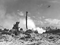 Battle of Eniwetok
 -
 B-17 drone at Eniwetok Airfield in 1948 for Operation Sandstone
 -
 Operation Sandstone
 -
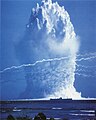
 Ivy Mike test, October 31, 1952
 -
 Operation Greenhouse test
 -
 Ivy King test, November 1952
 -
 Test shot Seminole ofOperation Redwing,conducted on the coast of the island ofBogon
 -
 Red-wing Seminole test
 -
 Hardtack Umbrella test
 -
Video clips of three test nuclear explosions in Eniwetok, Marshall Islands
-
Test shotNectarofOperation Castleproduced a yield of 1.69megatonsand was detonated just north east of Ivy Mike'sElugelabcrater. The Island ofBogonis thespearheadshaped object at the bottom right of the screen, as it was before the Redwing Seminole test was conducted on that island.


Missile Impact Location System
[edit]From 1958 through 1960 the United States installed theMissile Impact Location System(MILS) in the Navy managed Pacific Missile Range, later the Air Force managedWestern Range,to localize the splash downs of test missile nose cones. MILS was developed and installed by the same entities that had completed the first phase of the Atlantic and U.S. West CoastSOSUSsystems. A MILS installation, consisting of both a target array for precision location and a broad ocean area system for good positions outside the target area, was installed at Eniwetok as part of the system supportingIntercontinental Ballistic Missile(ICBM) tests. Other Pacific MILS shore terminals were at theMarine Corps Air Station Kaneohe BaysupportingIntermediate Range Ballistic Missile(IRBM) tests with impact areas northeast of Hawaii and the other ICBM test support systems atMidway IslandandWake Island.[57][58][59]
In popular culture
[edit]- The short story "The Terminal Beach"byJ. G. Ballardis set on an island of Eniwetok in the aftermath of the nuclear tests.[60]
Notes
[edit]- ^There is a discrepancy related to the total number of tests conducted: 42 or 43. The total number is 43, but two tests (HARDTACK I SCAEVOLA and HARDTACK I QUINCE) were with zero yield: one was a safety test, the other did not work out.[18]And sometimes one of them doesn't count. Another source of this discrepancy is the widely cited article by Simon and Robison, the summary of which lists the total number of tests conducted at Enewetak Atoll as 42 (including two tests with zero yield), although the attached table lists data for all 43 tests.[19]
- ^A 15 kiloton nuclear weapon exploded but did not undergo nuclear fission on Runit, scattering plutonium over the island. Runit Island is not habitable for the next 24,000 years, which is why it was chosen for the nuclear waste repository. See: Wargo, John.Green Intelligence: Creating Environments That Protect Human Health.New Haven, Conn.: Yale University Press, 2009, p. 15.
- ^The government said that the northern islands would not be safe for inhabitation until 2010. See: Johnson,Bulletin of the Atomic Scientists,p. 25.
- ^Cesium,which is highly radioactive, is chemically similar to potassium. Since the atoll is deficient in potassium, plants absorb cesium from the ground instead. This makes the plants inedible. Cesium also is deposited in the muscles of the human body, just as potassium is. See:Firth, Stewart (1987).Nuclear Playground.Honolulu: University of Hawaii Press. p.36.ISBN0824811445.
- ^The Hardtack I Yucca test was conducted using a stratospheric balloon. The ship with this balloon departed from Bikini Atoll. The launch of this balloon was made between Enewetak and Bikini Atolls, slightly closer to Bikini. The surface zero was closer to Enewetak Atoll. Therefore this test can only be conditionally classified as a test performed at Enewetak Atoll.[56]
References
[edit]- ^abcdBrinkhoff, Thomas (2022-06-11)."Marshall Islands".City Population.Retrieved2023-01-19.
- ^"Eniwetok".LexicoUK English Dictionary.Oxford University Press.Archived fromthe originalon March 22, 2020.
- ^"Marshallese-English Dictionary - Place Name Index".trussel2.
- ^"Enewetak Atoll – nuclear trash can of the pacific – UTAOT".utaot.Archived fromthe originalon 2013-05-24.Retrieved2013-04-14.
- ^A Pacific isle radioactive and forgotten,The New York Times,Michael B. Gerrard, December 3, 2014. Retrieved 19 September 2016.
- ^Hacker, Barton C. (1994).Elements of controversy: the Atomic Energy Commission and radiation safety in nuclear weapons testing, 1947–1974.Berkeley, CA: University of California Press. p. 14.ISBN0520083237.
- ^Clouard, Valerie; Bonneville, Alain (2005). "Ages of Seamounts, Islands and Plateaus on the Pacific Plate". In Foulger, Gillian R.; Natland, James H.; Presnall, Dean C.; et al. (eds.).Plates, Plumes, and Paradigms.Boulder, Colo.: Geological Society of America. pp. 71–90 [p. 80].ISBN0813723884.
- ^Ludwig, K. R.; Halley, R. B.; Simmons, K. R.; Peterman, Z. E. (1988). "Strontium-Isotope Stratigraphy of Enewetak Atoll".Geology.16(2): 173–177 [p. 173–174].Bibcode:1988Geo....16..173L.doi:10.1130/0091-7613(1988)016<0173:SISOEA>2.3.CO;2.
- ^Schlanger, S. O.; Campbell, J. F.; Jackson, M. W. (1987). "Post-Eocene subsidence of the Marshall Islands Recorded By Drowned Atolls on Harrie and Sylvania Guyots". In Keating, B. H.; et al. (eds.).Seamounts, Islands, and Atolls.Geophysical Monograph Series. Vol. 43. Washington, D.C.: American Geophysical Union. pp. 165–174 [p. 173].ISBN0875900682.
- ^Munk, Walter; Day, Deborah (2004)."Ivy-Mike".Oceanography.17(2): 97–105 [p. 98].doi:10.5670/oceanog.2004.53.
- ^Hezel 1994,p. 3.
- ^Hezel 1994,p. 16-17.
- ^Brand, Donald D.The Pacific Basin: A History of its Geographical ExplorationsThe American Geographical Society, New York, 1967, p.122
- ^Churchill, William(1920). "Germany's Lost Pacific Empire".Geographical Review.10(2): 84.JSTOR207706.
- ^"Tích はサイパンもパラオも “Nhật Bản” だった ── Nhật Bản の Nam Dương quần đảo thống trị ".teikoku-denmo.jp.
- ^Carter, Worrall Reed.Beans, Bullets, and Black Oil: The Story of Fleet Logistics Afloat in the Pacific During World War II.Washington, D.C.: Department of the Navy, 1953, p. 163.
- ^abcChapter XXVII Bases in the Central Pacific, Building the Navy's Bases in World War II, History of the Bureau of Yards and Docks and the Civil Engineer Corps, 1940-1946, Volume II, UNITED STATES GOVERNMENT PRINTING OFFICE, WASHINGTON, 1947, p.325[1]
- ^"Operation HARDTACK I"(PDF).Defense Threat Reduction Agency. September 2021. pp. 2–3.Retrieved2024-07-29.
- ^Simon, S.L.; Robison, W.L. (July 1997)."A Compilation of Nuclear Weapons Test Detonation Data for U.S Pacific Ocean Tests"(PDF).Health Physics.73(1): 258–64.doi:10.1097/00004032-199707000-00022.Archived fromthe originalon November 10, 2004.Retrieved2024-07-29.
- ^Diehl, Sarah and Moltz, James Clay.Nuclear Weapons and Nonproliferation: A Reference Book.Santa Barbara, Calif.: ABC-CLIO, 2002, p. 208.
- ^Chapman, Kit (January 14, 2020)."Element Hunting in a Nuclear Storm".Distillations.Science History Institute.RetrievedJanuary 14,2020.
- ^"F-84G-5-RE Thunderjet Serial Number 51-1040".Pacific Wrecks.Retrieved9 January2020.
- ^Wolverton, Mark (2009)."Into the Mushroom Cloud: Most pilots would head away from a thermonuclear explosion".Air & Space Magazine(August). Smithsonian.Retrieved9 January2020.
- ^Johnson, Giff (1980)."Paradise lost".Bulletin of the Atomic Scientists.36(10): 24–29.doi:10.1080/00963402.1980.11458792.ISSN0096-3402.
- ^abSchwartz, Stephen I. (2011-12-01).Atomic Audit: The Costs and Consequences of U.S. Nuclear Weapons Since 1940.Brookings Institution Press.ISBN978-0-8157-2294-6.
- ^Johnson,Bulletin of the Atomic Scientists,p. 24.
- ^Linsley, Gordon. "Site Restoration and Cleanup of Contaminated Areas." InCurrent Trends in Radiation Protection: On the Occasion of the 11th International Congress of the International Radiation Protection Association, 23–28 May 2004, Madrid, Spain.Henri Métivier, Leopoldo Arranz, Eduardo Gallego, and Annie Sugier, eds. Les Ulis: EDP Sciences, 2004, p. 142.
- ^Philipps, Dave (Jan 28, 2017)."Troops Who Cleaned Up Radioactive Islands Can't Get Medical Care".The New York Times.
- ^Mohamed, Carlotta (August 12, 2022)."President Biden signs Queens lawmaker's bill into law to provide health care benefits for veterans exposed to radiation".QNS.Archivedfrom the original on 2022-08-13.
- ^abcdeGraham, Bill. "Written Testimony of Bill Graham, Public Advocate (retired), Marshall Islands Nuclear Claims Tribunal." Subcommittee on Asia, the Pacific, and the Global Environment. Committee on Foreign Affairs. United States House of Representatives. May 20, 2010.ArchivedOctober 25, 2012, at theWayback MachineAccessed 2012-11-01.
- ^ab"Loss-of-Damages From U.S. Nuclear Testing in the Marshall Islands: Technical Analysis of the Nuclear Claims Tribunal Methodology and Alternative Estimate"(PDF).Archived fromthe original(PDF)on 2014-08-06.Retrieved2014-01-21.
- ^Willacy, Mark (November 27, 2017)."A poison in tour island".ABC.RetrievedNovember 27,2017.
- ^The Compact was ratified by both nations in 1986.
- ^Louka, Elli.Nuclear Weapons, Justice and the Law.Northampton, Mass.: Edward Elgar, 2011, p. 161-162.
- ^Richey, Warren (April 5, 2010)."Supreme Court: No Review of Award for US Nuclear Weapons Tests".Christian Science Monitor.
- ^"Public SchoolsArchived2018-02-21 at theWayback Machine."Marshall Islands Public School System. Retrieved on February 21, 2018.
- ^"Annual Report 2011-2012Archived2018-02-22 at theWayback Machine."Ministry of Education (Marshall Islands).Retrieved on February 22, 2018. p. 54 (PDF p. 55/118). "Marshall Islands High Schools [sic] takes students from Ratak Rak zone including schools in Majuro, Arno, Mili, and Enewetak/Mejatto. "
- ^abBureau of Yards and Docks 1947,p. 325.
- ^Carey, Alan (1999).The Reluctant Raiders: The Story of United States Navy Bombing Squadron VB/VPB-109 During World War II.Schiffer Publishing. p. 64.ISBN9780764307577.
- ^Morison, Samuel (1975).History of United States Naval Operations in World War II. Volume VI: Aleutians, Gilberts and Marshalls, June 1942-April 1944.U.S. Government Printing Office. p. 306.
- ^Bureau of Yards and Docks 1947,p. 326.
- ^Roberts 2000,p. 135.
- ^Roberts 2000,p. 186.
- ^Roberts 2000,p. 522-3.
- ^Roberts 2000,p. 623.
- ^Roberts 2000,p. 544.
- ^Roberts 2000,p. 35.
- ^abRoberts 2000,p. 410.
- ^Roberts 2000,pp. 233–4.
- ^Roberts 2000,p. 431.
- ^Roberts 2000,p. 267.
- ^Roberts 2000,p. 392.
- ^Roberts 2000,p. 591.
- ^Roberts 2000,p. 295.
- ^Roberts 2000,p. 236.
- ^"YUCCA NUCLEAR TEST".StratoCat.Retrieved2024-07-29.
- ^"Integrated Undersea Surveillance System (IUSS) History 1950 - 2010".IUSS/CAESAR Alumni Association.Retrieved11 February2020.
- ^Subcommittee on Military Construction (March–April) (April 29, 1959).Military Construction Appropriations for 1960: Hearings.pp. 169–170.Retrieved16 September2020.
- ^Subcommittee on Military Construction (May) (May 20, 1959).Military Construction Appropriations for 1960: Hearings.pp. 818, 824.Retrieved16 September2020.
- ^Ballard 1964,p. 136.
Bibliography
[edit]- Roberts, Michael D. (2000).Dictionary of American Naval Aviation Squadrons, Volume 2: The History of VP, VPB, VP(H) and VP(AM) Squadrons.Washington, D.C.: Naval Historical Center, Department of the Navy.Retrieved2015-01-22.
- Bureau of Yards and Docks (1947).Building the Navy's Bases in World War II: History of the Bureau of Yards and Docks and the Civil Engineer Corps, 1940-1946.U.S. Government Printing Office.
- Hezel, Francis X. (1994) [1983].The First Taint of Civilization: A History of the Caroline and Marshall Islands in Pre-colonial Days, 1521-1885.University of Hawaii Press.ISBN978-0-8248-1643-8.
- Ballard, J. G. (1964).The Terminal Beach.Carroll and Graf.ISBN0-88184-370-9.
External links
[edit]![]() This article incorporatespublic domain materialfrom theAir Force Historical Research Agency
This article incorporatespublic domain materialfrom theAir Force Historical Research Agency
- Marshall Islands site
- Entry at Oceandotsat theWayback Machine(archived December 23, 2010)
- Annotated bibliography for Eniwetok Atoll from the Alsos Digital Library for Nuclear Issues
- Information on legal judgements to the people of Enewetak
- Nursing a nuclear test hangover( watoday.au report on Runit Dome, August 18, 2008)
- Enewetak Atoll Atomic Debris Cleanup Mission Survivors
- ABC News documentary, 41minonYouTube
Marshall Islandsarticles | |||||||
|---|---|---|---|---|---|---|---|
| History | |||||||
| Geography |
| ||||||
| Politics |
| ||||||
| Economy | |||||||
| Culture |
| ||||||
| |||||||
| International | |
|---|---|
| National | |
| Other | |