
Garut
Garut | |
|---|---|
Town | |
   Clockwise from the top: Great Mosque of Garut,Alun-alun Garut, Babancong Pavilion | |
| Nicknames: Kota Intan(Diamond City) Zwitserse Van Java(Switzerland of Java) | |
| Motto: Tata Tengtrem Kerta Raharja | |
| Coordinates:7°13′S107°54′E/ 7.217°S 107.900°E | |
| Country | Indonesia |
| Region | Java |
| Province | West Java |
| Regency | Garut Regency |
| Area | |
| • Total | 27.71 km2(10.70 sq mi) |
| Elevation | 717 m (2,520 ft) |
| Population (mid 2022 estimate) | |
| • Total | 127,980 |
| • Density | 4,600/km2(12,000/sq mi) |
| [1] | |
| Time zone | UTC+7(IWST) |
| Area code | (+62) 262 |


Garutis a district and town inWest JavaofIndonesia,and the former capital ofGarut Regency.It is located about 75 km to the southeast of the major city ofBandung.
History
[edit]The modern history of Garut started on 2 March 1811 when the Balubur Limbangan Regency was dissolved byGovernor GeneralHerman Willem Daendelsbecause the area's production of coffee had decreased and theRegent,Tumenggung Wangsakusumah II, had refused a command to plant indigo. Balubur Limbangan Regency then comprised 6 districts: Balubur, Malangbong, Wanaraja, Wanakerta, Cibeureum and Papandak.
The Limbangan Regency, which has now become theGarut Regency,was founded by Lieutenant-GovernorStamford Raffleson 16 February 1813. RAA. Adiwijaya, who governed from the 1813 until 1821, was the first Regent of theGarut Regency.He was well known as Dalem Cipeujueh. The town of Suci was originally the capital of the new Limbangan Regency. However it was thought that Suci did not meet the requirements of a capital because the area was crowded and quite narrow.
Regarding this matter,RegentLimbangan Adipati Adiwijaya formed a committee to find a suitable place for the capital of the Regency. In the beginning, the committee found Cimurah, about 3 km to the East Suci (currently the village is known by the name of Pidayeuheun Village). However, in this place clean water was difficult to obtain so the place not regarded as suitable to become the capital. The committee then decided that a suitable place was about 5 km to west of Suci. In addition to fertile land, the place has a spring that flows to the River Cimanuk and is surrounded by mountains, like Mount Cikuray,Mount Papandayan,Mount Guntur,Mount Galunggung,Mount Talaga Bodas,Kandangwesiand Mount Karacak.
When the site was first found, there was a spring nearby that was said to have been surrounded by a small pond closed off by thorny scrub. According to local stories, one person in the group had his hands badly scratched by the thorns. A European in the team asked about the bleeding and was told that the problem was "kakarut!" The answer was misheard by the European visitor as "gagarut" rather than "kakarut". Team members of the committee thus named the thorny plant "Ki Garut" and the pond was named "Ci Garut" (the location of this pond now was occupied by SLTPI, SLTPII, and SLTP IV Garut buildings). The area around the pond was named "Garut". The name of "Garut" was approved byRegentLimbangan Adipati Adiwijaya to be made the Capital of the Limbangan Regency.
On 15 September 1813 the development of capital facilities and infrastructure, such as residence, the hall, office assistant resident, mosques, and square was started. In front of the hall, between the town square and the hall was gotten by "Babancong" where theRegentas well as the official of the other government gave the speech in front of the public. After the place was completed earlier, the Capital of the Limbangan Regency moved from Suci to Garut around 1821. Based on theGovernor GeneralDecree No: 60 dated May 7, 1913, the name of the Limbangan Regency was replaced to theGarut Regencyand had a capital the Garut city on July 1, 1913. At that time, the Regent was RAA is Wiratanudatar (1871–1915). Garut city at that time covering the three villages, namely Kota Kulon (West City) village, the Kota Wetan (East City) Village, and Margawati Village. TheGarut Regencycovered Garut districts, Bayongbong, Cibatu, Tarogong, Leles, Balubur Limbangan, Cikajang, Pakenjeng, Bungbulang and Pameungpeuk. In the year 1915, RAA Wiratanudatar replaced by his nephew of Adipati Suria Karta Legawa (1915–1929). On August 14, 1925, a decision based on the Governor General,Garut Regencygovernment passed a stand-alone (autonomous). [2]
Gallery
-
 The sanatorium of Garut in the 1920s
 -
 The Regent of Garut, Raden Adipati Aria Wiratanudatar VII, with his wife RA Lasminingrat (sitting) and his family.
 -
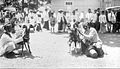 Goat fights in Garut (1921)
 -
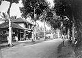 The main street of Garut in 1936
 -
 Lake Bagendit in Garut, 1932


Tourism and incidents
[edit]Garut was of importance even beforeWorld War II,being a hill station for the Dutch elite of the region.[3]
The Danish writerJohannes V. Jensenaccounted his visit to Garut in the short storyPaa Javafrom1915.[4] The legendary film starCharlie Chaplinis said to have visited Garut twice. He is reported to have visited in 1927 and 1935, staying at the Grand Hotel Ngamplang in Cilawu region, a hilly resort around 3.4 kilometers from the city center.[citation needed]
More recently, Garut is a centre of tourism in the region south of Bandung for hiking, hot spas, nearby lakes and villages, and so on.[5]Nearby sites include the following:[6]
- Mount Papandayan,about 15 km to the southwest of Garut.
- TheKamojang crater,a geothermal field and tourist spot, is located on the slopes of Mount Guntur approximately 25 km to the northwest of Garut.

- TheCangkuang Hindu temple,near the village of Leles, is around 10 km towards the north of the town of Garut on the road to Bandung. The temple, said to have been built during the period of the Galuh Sundanese kingdom in the 8th century, is one of the few Hindu sites in West Java. The restored temple is on the edge of Cangkuang lake where there is a campsite and a few bungalows.[7]
- Curug Orok, a group of waterfalls (curugin Indonesian).
- Masjid Asy-Syuro is a mosque that has an art-deco architecture. Therefore, this mosque looks like a church because of its architectural style. This is a conserved building in Garut. Built in 1934 and finished in 1936. It consists of a hall, a "mimbar", and a tower. This building has a thick wall and stone decoration at its lower part. This mosque is located at Kampung Cipari, Desa Sukarasa, Kecamatan Pangatikan (previously Wanaraja). This building had been functioned as a shelter and fortress while a civil and political conflict ofDarul Islamor Tentara Islam Indonesia movement. Now this mosque is still used as a normal mosque for praying and a center of Pesantren Cipari, a traditional and modern Islamic boarding school complex.
- Kawah Talaga Bodas, a with and cyan crater.
- Kebun Mawar Situhapa, a rose plantation garden at the District of Samarang.
- Kampung Bali, a gallery of ancient heritage such as Keris, Tombak, Script, Jewelry, etc. This place is located at District of Cibatu.
- Taman Satwa Cikembulan, a mini zoo and kids play ground at the District of Leles, about 1 kilometer from Situ Cangkuang.
- Desa Wisata Domba or also known as De Wisdom. This is a tourism spot with Sheep/Lamb theme.
- Karacak Valley, is a camping site at Mount Karacak.
- Darajat Pass, a hot spring pools spot at the hill of Kamojang, This place is located at District of Samarang.
- Cipanas Tarogong is a village with so many hotels and hot spring pools at the District of Tarogong.
- Sukaregang Leather Home Industry Center, a perfect spot for shopping leather products with affordable price. This place is located At The District of Garut Kota.
To facilitate the tourists who want to explore Garut tourism destination, there are tour operator companies who can be contacted.
Local foods
[edit]- Dodolis among the famous local cuisines from Garut. Dodol is made fromrice flour,glutinous riceflour,brown sugar,andcoconut milk.Dodol, which is popular because it is sweet and sticky, is prepared with many different fruit flavours.
- Dorokdok(Skin Crackers).Dorokdokis usually made from driedWater Buffalo's skin. The only way to make it is to fry the dried skin.Dorokdokis popular because it is crunchy and salty.
- Burayotmade ofBrown Sugarand Chosen rice flour. The ingredients and taste are same as that found in other versions of the regional specialty known as "Ali Agrem"but because burayot is round and wrinkled (or"ngaburayot"in Sundanese) it calledburayot.Burayot is produced in the region around the small township of Leles to the north of Garut because the ingredients are easily available in the area.
- Chocodotis a mixture of Chocolate and Dodol. It is a new emerging brand for souvenir snack from Garut.
- Rangginangis a kind of chips made from a processed rice called ketan. Its salty and crunchy.
- Daprosis a kind of colorful chips with a bloom rose shape.
- Leupeutis another kind of rice. Packed with banana leave. It is often used as a substitution of rice while traveling.
Volcanoes
[edit]
Garut is in a valley surrounded by various volcanoes. The most well known is MountGalunggungwhich experienced a major eruption in 1982. Following the eruption, over 60 people died and much damage was done to the agricultural sector and infrastructure in the region. Other nearby volcanoes are MountTalagabodas(around 2,200 meters),Mount Guntur(around 2,250 meters), and Mount Cikurai (over 2,900 meters).
Beaches
[edit]At the south of Garut there are more than 10 beaches. The most well known beaches are Santolo Beach at Cikelet district and Sayang Heulang Beach, the others are Cilauteureun, Rancabuaya, Taman Manalusu, Cijayana, Karang Paranje, Sancang, Gunung Geder, Pantai Cijeruk Indah, Karang Tepas or Sodong parat. They are located 94 kilometers from Garut and spread along 72 kilometers of south coast.Franz Wilhelm Junghuhnin the colonial era plotted the beaches. Now, since 2006 Gunung Geder Beach is boosted by the Indonesian government to be a new tourist site. Gunung Geder Beach with 7 kilometers of beach has white sand near the sea and brownish sand far the sea. Alternative route besides through Garut is throughCiwideyandRancabali.[8]
Greater Garut
[edit]The urban area of Garut town (Kota) extends into three adjacent districts, with a combined area of 149.81 km2and an official estimated population of 482,890 in mid 2022.[1]
| District | Area in km2. |
Pop'n 2010 census |
Pop'n 2020 census |
Pop'n mid 2022 estimate |
Admin centre |
No. of Villages |
Post code |
|---|---|---|---|---|---|---|---|
| Tarogong Kidul | 19.46 | 108,192 | 114,965 | 116,490 | Sukakarya | 12 | 44150 |
| Tarogong Kaler | 50.57 | 84,843 | 95,942 | 98,390 | Cimanganten | 13 | 44151 |
| Kota Garut | 27.71 | 126,452 | 127,583 | 127,980 | Pakuwon | 11 | 44111 - 44119 |
| Karangpawitan | 52.07 | 116,833 | 135,814 | 140,030 | Sindanglaya | 20 | 44182 |
Notes
[edit]- Witton, Patrick (2003).Indonesia (7th edition).Melbourne: Lonely Planet. p. 166.ISBN1-74059-154-2.
- SeeOfficial website of Garut Regencyfor useful details and links.
References
[edit]- ^abBadan Pusat Statistik, Jakarta, 2023.
- ^Vickers, Adrian. 2005.A History of ModernIndonesia,Cambridge: University of Cambridge Press, p. 29.
- ^"Asia's Highlands".Wall Street Journal.2007-05-25.ISSN0099-9660.Retrieved2021-09-15.
- ^Johannes V. Jensen(2001). Niels Birger Wamberg (ed.).Hos fuglene: Noveller af Johannes V. Jensen(in Danish) (1st ed.).Gyldendal.ISBN978-87-00-47184-9.OCLC469419005.WikidataQ55994517.
- ^Ika Krismantari, 'Garut: The Hidden Beauty of West Java',The Jakarta Post,19 April 2011.
- ^Kuntarini Rahsilawati, 'Garut and Tasikmalaya: Jades of tropics near Jakarta'Archived2013-02-04 atarchive.today,The Jakarta Post,24 September 2006.
- ^Simon Marcus Gower, 'Gliding to a restful temple near Garut',The Jakarta Post,11 December 2009.
- ^(Indonesian)Most Exotic Than KutaArchived2011-05-21 at theWayback Machine
| International | |
|---|---|
| National | |