
Georgetown, Quitman County, Georgia
Georgetown | |
|---|---|
City | |
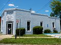
 Georgetown in 2012. | |
 Seal | |
 Location inQuitman Countyand the state ofGeorgia | |
| Coordinates:31°53′02″N85°06′05″W/ 31.88389°N 85.10139°W | |
| Country | United States |
| State | Georgia |
| Counties | Quitman |
| Area | |
| • Total | 3.9 sq mi (10.2 km2) |
| • Land | 2.7 sq mi (7.1 km2) |
| • Water | 1.2 sq mi (3.1 km2) |
| Population (2020) | |
| • Total | 2,235 |
| • Density | 570/sq mi (220/km2) |
| ZIP codes | 39854 |
| Area code | 229 |
Georgetownis a city inQuitman County, Georgia,United States. It is on theAlabama-Georgiastate line next toWalter F. George Lakeand across theChattahoochee RiverfromEufaula, Alabama.Per the2020 census,the population was 2,235.[1]In 2006, Georgetown and Quitman County voted toconsolidatetheir governments, becoming the smallest such consolidated entity in theLower 48states.[2]
History
[edit]Settled in the early 1830s, Georgetown was first named Tobanana for the nearby creek. The Tobanana Post Office was established on January 10, 1833. On September 21, 1836, the name of the town was changed to "Georgetown" after thehistoric neighborhoodinWashington, D.C.[3]
Georgetown was designated in 1859 as thecounty seatof Quitman County and was laid out as a town by order of the Inferior Court. The town was incorporated by an act of the legislature on December 9, 1859.
A brigade of federal cavalry, commanded byGeneral Benjamin H. Grierson,camped for a time near Georgetown on the banks of the Tobanana Creek at the close of theAmerican Civil War.
Georgetown was destroyed by fire in 1903; every building except for the post office and three houses were destroyed.
Geography
[edit]According to theUnited States Census Bureau,the city has a total area of 3.9 square miles (10 km2), of which 2.7 square miles (7.0 km2) is land and 1.2 square miles (3.1 km2) (30.46%) is water.
U.S. Route 82,as well as Georgia State Routes27and39,are the main highways through the city. U.S. 82 runs west–east through the city as Middle Street, leading west 3 mi (4.8 km) toEufaula,Alabamaacross theChattahoochee Riverand southeast 24 mi (39 km) toCuthbert.GA-39 runs north–south through the city briefly concurrent with U.S. 82, leading north 22 mi (35 km) toOmahaand south 23 mi (37 km) toFort Gaines.GA-27 begins in the city and leads northeast 24 mi (39 km) toLumpkin.
Demographics
[edit]| Census | Pop. | Note | %± |
|---|---|---|---|
| 1870 | 263 | — | |
| 1880 | 245 | −6.8% | |
| 1890 | 348 | 42.0% | |
| 1900 | 348 | 0.0% | |
| 1910 | 313 | −10.1% | |
| 1920 | 244 | −22.0% | |
| 1930 | 345 | 41.4% | |
| 1940 | 367 | 6.4% | |
| 1950 | 550 | 49.9% | |
| 1960 | 554 | 0.7% | |
| 1970 | 860 | 55.2% | |
| 1980 | 935 | 8.7% | |
| 1990 | 913 | −2.4% | |
| 2000 | 973 | 6.6% | |
| 2010 | 2,513 | 158.3% | |
| 2020 | 2,235 | −11.1% | |
| U.S. Decennial Census[4] 2010[5]2020[6] | |||
| Race / Ethnicity(NH = Non-Hispanic) | Pop 2010[5] | Pop 2020[6] | % 2010 | % 2020 |
|---|---|---|---|---|
| Whitealone (NH) | 1,265 | 1,190 | 50.34% | 53.24% |
| Black or African Americanalone (NH) | 1,198 | 917 | 47.67% | 41.03% |
| Native AmericanorAlaska Nativealone (NH) | 3 | 13 | 0.12% | 0.58% |
| Asianalone (NH) | 2 | 12 | 0.08% | 0.54% |
| Pacific Islanderalone (NH) | 0 | 0 | 0.00% | 0.00% |
| Some Other Racealone (NH) | 0 | 9 | 0.00% | 0.40% |
| Mixed Race or Multi-Racial(NH) | 11 | 63 | 0.44% | 2.82% |
| Hispanic or Latino(any race) | 34 | 31 | 1.35% | 1.39% |
| Total | 2,513 | 2,235 | 100.00% | 100.00% |
In 2000,[7]there were 973 people, 367 households, and 274 families residing in the city. The population density was 355.0 inhabitants per square mile (137.1/km2). By the 2020 census, there were 2,235 people residing in the city, up from 2,513 in 2010.[5][6]
Education
[edit]TheQuitman County School Districtholds grades pre-school to grade twelve. It consists of one elementary-middle school, and onehigh schoolthat consists of grades ninth through twelfth.[8]The district has 22 full-time teachers and over 314 students.[9]
County students attended Stewart-Quitman High School (nowStewart County High School) from 1978, until Quitman County High opened,[10]in 2009.[citation needed]
Notable residents
[edit]- Bryant T. Castellow(1876–1962), born near Georgetown; a politician, educator and lawyer
- The Castellows,country music trio
- Gladys L. Catchings(1901–1992), born in Georgetown; a nurse, hospital administrator and educator
Gallery
[edit]-
 Quitman CountyCourthouse was built in 1939 by thePublic Works Administrationusing federal relief funds. It was added to theNational Register of Historic Places.
 -
 The old Quitman County Jail. It was added to theNational Register of Historic Places.
 -
 Georgetown City Hall.
 -
 Georgetown Post Office (ZIP code:39854)


References
[edit]- ^"Georgetown CDP, Georgia".United States Census Bureau.RetrievedApril 15,2022.
- ^"New Georgetown-Quitman County Government Sets Consolidation Record".Carl Vinson Institute of Government, University of Georgia.RetrievedJune 20,2015.
- ^Krakow, Kenneth K. (1975).Georgia Place-Names: Their History and Origins(PDF).Macon, GA: Winship Press. p. 92.ISBN0-915430-00-2.
- ^"Decennial Census of Population and Housing by Decades".US Census Bureau.
- ^abc"P2 Hispanic or Latino, and Not Hispanic or Latino by Race – 2010: DEC Redistricting Data (PL 94-171) – Georgetown CDP, Georgia".United States Census Bureau.
- ^abc"P2 Hispanic or Latino, and Not Hispanic or Latino by Race – 2020: DEC Redistricting Data (PL 94-171) – Georgetown CDP, Georgia".United States Census Bureau.
- ^"U.S. Census website".United States Census Bureau.RetrievedJanuary 31,2008.
- ^Georgia Board of Education[permanent dead link],Retrieved June 25, 2010.
- ^School Stats,Retrieved June 25, 2010.
- ^"Stewart - Quitman County High School is Splitting Up".WTVM.August 14, 2008.RetrievedMay 21,2021.
External links
[edit]Municipalities and communities ofQuitman County, Georgia,United States | ||
|---|---|---|
| City | 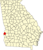 | |
| Unincorporated communities | ||